

EuroSDR Projects - Host Ireland
EuroSDR Projects - Host Ireland
EuroSDR Projects - Host Ireland

Create successful ePaper yourself
Turn your PDF publications into a flip-book with our unique Google optimized e-Paper software.
228<br />
road cluster is refined by removing big open areas, i.e., buildings, parking lots, fields, etc., again<br />
by means of a fuzzy classification based on a shape descriptor using the Angular Texture<br />
Signature (Zhang and Couloigner 2005a, 2006b). Road segments are found from the refined<br />
clusters via a localized and iterative Radon transform with window size 31 by 31 pixels with<br />
improved peak selection for thick lines (Zhang and Couloigner 2005b, 2005c). The segments are<br />
grouped bridging gaps smaller than five pixels and forming intersections. Finally, only segments<br />
longer than twenty pixels are retained.<br />
The results of the evaluation are summarized in Table 1. It is ordered in the first instance according to<br />
the test areas (from analog to digital aerial to satellite data) and in the second instance alphabetically<br />
according to the group and possibly its approaches. For each test area where more than one result is<br />
available, the best result in terms of the geometric mean of completeness and correctness is marked in<br />
bold. In addition, all values for completeness or correctness, which are beyond a value of 0.6 or 0.75<br />
respectively, are marked in bold. These numbers can be seen as a lowest needed limit so that the<br />
results become practically useful. The value for correctness was set to a higher value as experience<br />
shows that it is much harder to manually improve given faulty results than to acquire roads from<br />
scratch. To be of real practical importance, in many cases both values probably need to be even<br />
higher, e.g., for correctness around 0.85 and for completeness around 0.7, but we have chosen the<br />
lower values, to distinguish ‘the probably useful’ for the obtained results from the rest.<br />
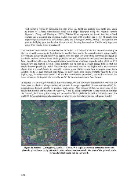
In Figures 1 to 10 we give one result for every image, besides the details from Ikonos3. Only for the<br />
latter have we obtained a larger number of results in the range beyond 0.85 for correctness and 0.7 for<br />
completeness deemed suitable for practical applications. Also because of that, we show some of the<br />
results for Ikonos3 and its details in Figures 5, 7, and 10 using a larger size. As the result for Beumier<br />
for Ikonos1_Sub1 is very interesting and the result of Gerke_WB for Aerial3 is definitely above 0.6<br />
and 0.75 for completeness and correctness, we also present them larger in size in Figures 6 and 2.<br />
Figure 1: Aerial1 – Zhang (left), Aerial2 – Gerke_WB (right); correctly extracted roads are<br />
given in green, incorrectly extracted roads in blue, and red marks the part of the ground truth<br />
for roads which could not be extracted.


