- Page 1 and 2: European Spatial Data Research Nove
- Page 3 and 4: PRESIDENT 2006 - 2008: Stig Jönsso
- Page 5 and 6: H. Kaartinen and J. Hyyppä: EVALUA
- Page 7 and 8: 4.3.1 Data and study area..........
- Page 9: 2 QUESTIONNAIRES...................
- Page 13 and 14: Abstract The objective of the EuroS
- Page 15 and 16: The analysis of the structural qual
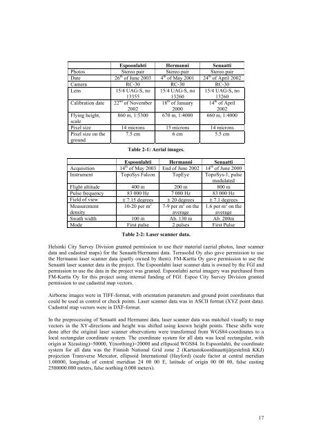
- Page 17: Figure 2-3: Hermanni test site. Fig
- Page 21 and 22: 2.2 Reference Data 2.2.1 Field Meas
- Page 23 and 24: Used data Time use Laser Aerial Gro
- Page 25 and 26: Step 3: Import to CCModeler Figure
- Page 27 and 28: Figure 3-4: Sequence of manual phot
- Page 29 and 30: Figure 3-8: Workflow of laser scann
- Page 31 and 32: Figure 3-11: Parametric building mo
- Page 33 and 34: Each group of connected pixels clas
- Page 35 and 36: Figure 3-18: Topological points and
- Page 37 and 38: Detailed Description (Letters refer
- Page 39 and 40: assumption is made: the two longest
- Page 41 and 42: Figure 3-25: A 3D building model wi
- Page 43 and 44: ICC used the same methods as Nebel
- Page 45 and 46: where p75th is the value at the 75
- Page 47 and 48: CyberCity Stuttgart Hamburg IGN ICC
- Page 49 and 50: CyberCity Hamburg Stuttgart IGN ICC
- Page 51 and 52: Height Cyber- City Hamburg Stuttgar
- Page 53 and 54: Height Cyber- City Stuttgart IGN IC
- Page 55 and 56: Height Cyber- City Stuttgart IGN IC
- Page 57 and 58: Height Cyber- City HamburgStuttgart
- Page 59 and 60: Height Cyber- City HamburgStuttgart
- Page 61 and 62: All targets Eaves Ridges Height IGN
- Page 63 and 64: CyberCity achieved a good quality i
- Page 65 and 66: Point density, shadowing of trees a
- Page 67 and 68: Height accuracy IQR [m] 1.6 1.4 1.2
- Page 69 and 70:
All Cyber- Ham- ICC laser+ Nebel+ I
- Page 71 and 72:
All Cyber- HamStutt- ICC laser+ Neb
- Page 73 and 74:
In building length determination (F
- Page 75 and 76:
degrees, std 6.3 degrees). In Senaa
- Page 77 and 78:
5 Discussion and Conclusions It can
- Page 79 and 80:
References Alharthy A. and Bethe, J
- Page 81 and 82:
Fraser, C.S., Baltsavias, E. and Gr
- Page 83 and 84:
Khoshelham K., 2004. Building Extra
- Page 85 and 86:
Sequeira, V., Ng, K., Wolfart, E.,
- Page 87 and 88:
Index of Figures Figure 2-1: Senaat
- Page 89:
Index of Tables Table 2-1: Aerial i
- Page 92 and 93:
90 Senaatti by Delft. Wireframe mod
- Page 94 and 95:
92 Espoonlahti by IGN, with and wit
- Page 96 and 97:
94 Senaatti by IGN, with and withou
- Page 98 and 99:
96 Hermanni by Aalborg.
- Page 100 and 101:
98 CyberCity ICC laser+aerial ICC l
- Page 102 and 103:
100 IGN FOI outlines Nebel+Partner
- Page 105 and 106:
Difference Images, Whole Test Site,
- Page 107 and 108:
Difference Images, Whole Test Site,
- Page 109 and 110:
Difference Images, Modelled Buildin
- Page 111 and 112:
Difference Images, Modelled Buildin
- Page 113:
EuroSDR-Project Commission 2 “Ima
- Page 116 and 117:
2 Project highlights The project Ch
- Page 118 and 119:
116 Feature Characteristics Object
- Page 120 and 121:
New are those combinations that ind
- Page 122 and 123:
120 Figure 4-1: Orthophotomosaic fr
- Page 124 and 125:
4.1.2 Segmentation The first step o
- Page 126 and 127:
124 Class Features Vegetation Ratio
- Page 128 and 129:
4.1.4 Change map As the results of
- Page 130 and 131:
Two types of changes were assigned
- Page 132 and 133:
130 Figure 4-11: Evaluation of chan
- Page 134 and 135:
132 Figure 4-13: Orthophotos of stu
- Page 136 and 137:
different villages were identified
- Page 138 and 139:
136 Figure 4-16: Change maps of Swi
- Page 140 and 141:
spectral reflectance. Shadows (blac
- Page 142 and 143:
140 Figure 4-19: Change map of Germ
- Page 144 and 145:
Figure 4-21: Diagnostics as given b
- Page 146 and 147:
144 Automatic Accepted Rejected Hum
- Page 148 and 149:
4.4.2 Segmentation, classification
- Page 150 and 151:
differentiated very well. The chang
- Page 152 and 153:
150 Figure 4-31: Ultracam real-colo
- Page 154 and 155:
152 Figure 4-35: Classification of
- Page 156 and 157:
154 Figure 4-38: Subset of change m
- Page 158 and 159:
5 Conclusions and Outlook In this p
- Page 161:
Annex 1 EuroSDR Change Detection Wo
- Page 164 and 165:
What is the impact of changing spat
- Page 167:
Annex 2 Paper presented at IGARSS05
- Page 170 and 171:
covering 2 x 2 km with reference da
- Page 172 and 173:
170 Red roof Bright object 0 20 40
- Page 175:
Annex 3 EuroSDR CD Workshop Nicosia
- Page 178 and 179:
176 method 1 indicates land cover c
- Page 181:
Annex 4 Comments on change map by B
- Page 184 and 185:
enzen mehr zu erwarten. Doch laut
- Page 187 and 188:
Abstract The EuroSDR “Sensor and
- Page 189 and 190:
2 Test Sites and Test Data The test
- Page 191 and 192:
Figure 3: Data set Fjärdhundra, ag
- Page 193 and 194:
The map of Sweden is only available
- Page 195 and 196:
3.2 Accounting for Different Acquis
- Page 197 and 198:
4 Analysis 4.1 Basic Information In
- Page 199 and 200:
4.2.2 Linear Objects Since it is no
- Page 201 and 202:
5 Results of Phase I 5.1 Test Site
- Page 203 and 204:
5.1.2 Qualitative Comparison In add
- Page 205 and 206:
140,0 120,0 100,0 80,0 60,0 40,0 20
- Page 207 and 208:
5.3 Test Site Oberpfaffenhofen 5.3.
- Page 209 and 210:
140,0 120,0 100,0 80,0 60,0 40,0 20
- Page 211 and 212:
cies in analysis. The following fig
- Page 213 and 214:
5.4.2 Qualitative Comparison The ra
- Page 215 and 216:
Acknowledgments We thank all partic
- Page 217:
Index of Tables Table 1: Contest Ph
- Page 221 and 222:
Abstract Roads are important object
- Page 223 and 224:
overview over the whole area. We ra
- Page 225 and 226:
m and above no longer plays an impo
- Page 227 and 228:
3 Test Data and Evaluation Criteria
- Page 229 and 230:
and straight enough. • Markus Ger
- Page 231 and 232:
Name (best) Test area Completeness
- Page 233 and 234:
• ADS40_1 and 2: Results for both
- Page 235 and 236:
• Ikonos1_Sub1: This image shows
- Page 237 and 238:
Figure 7: Ikonos3_Sub1 - Bacher; co
- Page 239 and 240:
Finally, we want to note some impor
- Page 241 and 242:
load nor response time for anybody
- Page 243:
Zhang, C., 2004. Towards an Operati
- Page 246 and 247:
objects, and their cooperation with
- Page 248 and 249:
Belgium, provided by their NMCAs. H
- Page 250 and 251:
Possibly only parts of images will
- Page 252 and 253:
How many people are employed in you
- Page 254 and 255:
7. What is the average time differe
- Page 256 and 257:
- what is the degree of completenes
- Page 259 and 260:
Appendix 3: Questionnaire for Resea
- Page 261 and 262:
If others please specify: 2. What d
- Page 263 and 264:
Complex crossings (more than 4 road
- Page 265 and 266:
Combination of a) or b) with c) [0]
- Page 267 and 268:
If yes, using: DTM and / or [2] D
- Page 269 and 270:
Appendix 4: General Characteristics
- Page 271:
Most important features for practic
- Page 274 and 275:
IKONOS The images come from the SI
- Page 277:
Appendix 6: Documentation by Beumie
- Page 281 and 282:
Appendix 8: Documentation by Zhang
- Page 283 and 284:
LIST OF OEEPE/EuroSDR OFFICIAL PUBL
- Page 285 and 286:
25 Ducher, G.: Test on Orthophoto a