

EuroSDR Projects - Host Ireland
EuroSDR Projects - Host Ireland
EuroSDR Projects - Host Ireland

Create successful ePaper yourself
Turn your PDF publications into a flip-book with our unique Google optimized e-Paper software.
The pictures show the same display level of detail, but do not possess the same geocoding. To create<br />
reference data, an identical geocoding of corresponding images was necessary to display the pictures<br />
with pixel accuracy in the same position. This operation was carried out using ERDAS software from<br />
Leica Geosystems. It should be noted, however, that the information of interest in the contest is not a<br />
correct coordinate interpretation concerning terrestrial coordinates but the correct detection and<br />
interpretation of objects and their classification. Therefore a superordinate georeferencing based on<br />
terrestrial coordinates was not essential.<br />
SAR data sets from Copenhagen and Fjärdhundra were provided by DDRE, Copenhagen; the data set<br />
from Oberpfaffenhofen was provided by DLR-IHR, Oberpfaffenhofen; and the data set from Trudering<br />
was provided by AeroSensing GmbH (now Intermap). The optical data set form Trudering was<br />
provided by Bayerisches Landesvermessungsamt, Munich; from Oberpfaffenhofen by DLR-IHR;<br />
from Fjärdhundra by Lantmäteriet, Sweden; and finally the data set from Copenhagen was provided<br />
by KAMPSAX, DDOland Denmark.<br />
The acquisition times were different for the four test sites. Fjärdhundra imagery was taken in July<br />
1995, Copenhagen in June 1996, Oberpfaffenhofen in May 1999 and finally the imagery from<br />
Trudering was taken in May 2000.<br />
2.2 Additional Data<br />
In addition to SAR and optical data, ground truth data were needed as additional sources of information<br />
about test regions and object types. Therefore, topographic maps for the areas around the test sites<br />
were collected. Topographic maps are, in general, approximations in that small objects are broadened<br />
but they also include more detailed information about the type of land use and classification. Table 4<br />
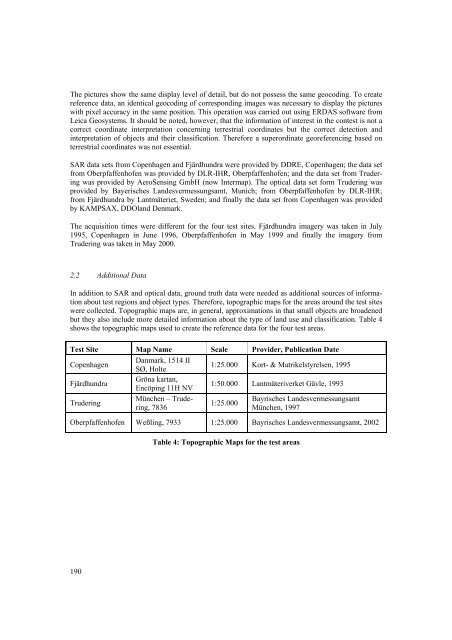
shows the topographic maps used to create the reference data for the four test areas.<br />
Test Site Map Name Scale Provider, Publication Date<br />
Copenhagen<br />
Danmark, 1514 II<br />
SØ, Holte<br />
1:25.000 Kort- & Matrikelstyrelsen, 1995<br />
Fjärdhundra<br />
Gröna kartan,<br />
Encöping 11H NV<br />
1:50.000 Lantmäteriverket Gävle, 1993<br />
Trudering<br />
München – Trudering,<br />
7836<br />
1:25.000<br />
Bayrisches Landesvermessungsamt<br />
München, 1997<br />
Oberpfaffenhofen Weßling, 7933 1:25.000 Bayrisches Landesvermessungsamt, 2002<br />
190<br />
Table 4: Topographic Maps for the test areas


