Macroalgae and phytoplankton as indicators of ... - Naturstyrelsen
Macroalgae and phytoplankton as indicators of ... - Naturstyrelsen
Macroalgae and phytoplankton as indicators of ... - Naturstyrelsen

You also want an ePaper? Increase the reach of your titles
YUMPU automatically turns print PDFs into web optimized ePapers that Google loves.
79<br />
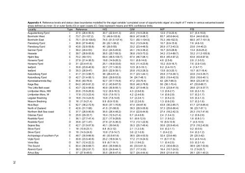
Appendix 4. Reference levels <strong>and</strong> status cl<strong>as</strong>s boundaries modelled for the algal variable 'cumulated cover <strong>of</strong> opportunistic algae' at a depth <strong>of</strong> 7 metre in various estuaries/co<strong>as</strong>tal<br />
are<strong>as</strong> defined <strong>as</strong> inner- (I) or outer fjords (O) or open co<strong>as</strong>ts (C). Data represent means <strong>and</strong> 95% confidence limits.<br />
Locality Type Reference H/G G/M M/P P/B<br />
Augustenborg Fjord I 37.5 (28.4-50.5) 30.7 (22.9-41.3) 20.5 (14.5-28.9) 12.9 (7.9-20.4) 9.7 (5.4-16.8)<br />
Bornholm West C 73.7 (51-107.2) 72 (49.9-103.8) 68.9 (47.8-98.7) 65.7 (45.6-94.4) 63.4 (44.6-93.9)<br />
Bornholm E<strong>as</strong>t C 75.1 (51.8-109.6) 74.5 (51.5-107.4) 72.1 (50.1-104.5) 70.3 (49-102.5) 68.5 (47.7-101.9)<br />
Flensborg Fjord I 36.8 (27.8-48.9) 29 (22.1-38.2) 18.2 (13.5-24.6) 10.7 (6.9-15.9) 7.6 (4.6-12)<br />
Flensborg Fjord O 43.8 (32.6-59.8) 40 (29.5-55) 33.2 (23.4-48.5) 26.9 (17.3-43.3) 23.6 (14-40.2)<br />
Genner Fjord I 39.2 (29.4-53) 33.2 (24.5-45.9) 24.1 (16.3-36.2) 16.7 (9.5-28.8) 13.4 (6.8-25.2)<br />
Hesselø C 39.7 (28.8-55.9) 38.5 (25.7-59.3) 36.8 (19.5-73.2) 34.2 (13.4-89.7) 33.2 (11.2-105.9)<br />
Hjelm Bay C 70.2 (49-101) 69.4 (48.5-100.7) 67.4 (46.7-98.1) 65.4 (45.4-97.2) 63.8 (43.8-97.9)<br />
Horsens Fjord I 27.9 (21.4-36.5) 19.8 (14.9-26.3) 10.1 (6.6-14.8) 4.6 (2.5-8) 2.8 (1.3-5.5)<br />
Horsens Fjord O 31 (23.4-41.6) 25.1 (18.9-33.6) 16.5 (11.4-23.8) 10.2 (5.9-16.7) 7.6 (3.9-13.6)<br />
Isefjord I 30.8 (23.6-40.9) 22.7 (17.1-30.3) 12.5 (8.3-18.1) 6.2 (3.4-10.7) 4 (1.9-7.7)<br />
Isefjord O 35.3 (26.9-47) 29.5 (22.6-39.1) 20.8 (15.2-28.3) 13.8 (9.3-20.1) 10.7 (6.7-16.4)<br />
Kalundborg Fjord I 41.7 (31.3-56.7) 38 (28.4-51.4) 31.7 (23.1-44.1) 25.8 (17.6-38.1) 22.6 (14.5-35.7)<br />
Kalundborg Fjord O 42.7 (31.4-58.1) 39.6 (29.6-53.9) 34 (24.7-48.1) 28.5 (19.4-42.5) 25.6 (16.6-40.1)<br />
Karrebæksminde Bay C 55.6 (40-76.9) 52.7 (37.7-74.8) 47.2 (33-70.4) 42 (26.7-68.3) 38.8 (23.2-67.3)<br />
Køge Bay C 64.2 (45.6-91.2) 61.2 (43.8-87.5) 55.8 (40.2-78.8) 50 (36.1-70.4) 47 (33.8-66.7)<br />
The Little Belt co<strong>as</strong>t C 43.7 (32.4-58.9) 40.9 (30.8-55.1) 36.2 (27.5-48.3) 31.4 (23.8-41.5) 28.6 (21.9-37.7)<br />
Limfjorden Mors, NW I 20.6 (15.8-26.9) 12.2 (8.9-16.3) 4.3 (2.6-6.9) 1.3 (0.6-2.7) 0.6 (0.2-1.5)<br />
Limfjorden Mors, W I 17.8 (13.3-23.4) 10.9 (7.6-15.1) 4.2 (2.4-6.9) 1.4 (0.6-2.9) 0.7 (0.2-1.7)<br />
Løgstør Bredning O 18.8 (14.3-24.5) 10.8 (7.8-14.8) 3.7 (2.2-6.1) 1.1 (0.5-2.3) 0.5 (0.2-1.3)<br />
Nissum Bredning O 16 (11.9-21.4) 9.9 (6.9-13.9) 3.8 (2.2-6.5) 1.3 (0.6-2.8) 0.7 (0.2-1.6)<br />
Nivå Bayt C 52.7 (38.2-72.5) 50.9 (37.1-70.8) 47.4 (34-67.6) 43.8 (30.2-65.7) 41.7 (27.8-65.4)<br />
North <strong>of</strong> Zeal<strong>and</strong> C 42.6 (31.7-58) 41.5 (31-56.9) 39.3 (28.5-55.6) 37.3 (25.6-56.4) 36 (23.7-57.1)<br />
Northern Belt Sea co<strong>as</strong>t C 37.7 (28.5-50.9) 35.5 (26.4-48.2) 31.4 (22.6-44.8) 27.4 (18.2-42.3) 25.3 (15.7-41.6)<br />
Odense Fjord O 25.9 (20-33.7) 16.4 (12.5-21.4) 6.7 (4.4-9.8) 2.4 (1.3-4.3) 1.2 (0.6-2.6)<br />
Roskilde Fjord I 36.1 (27.7-47.4) 22.7 (17.9-28.8) 9.1 (6.6-12.5) 3.1 (1.9-5.2) 1.6 (0.8-3.1)<br />
Roskilde Fjord O 35.6 (27.1-47) 27.9 (21.5-36.3) 17.3 (13.1-22.8) 10 (6.9-13.9) 7 (4.5-10.5)<br />
Sejerø Bay C 42.7 (31.9-57.9) 40.1 (30-54.8) 35.3 (25.7-49.4) 30.6 (20.9-45.4) 27.9 (18.2-43.8)<br />
Skive Fjord I 18 (13.8-23.1) 8.8 (6.3-12) 2.1 (1.2-3.8) 0.4 (0.2-1.1) 0.2 (0-0.5)<br />
Skive Fjord O 19 (14.5-24.8) 10.8 (7.8-14.7) 3.6 (2.1-5.9) 1 (0.4-2.2) 0.4 (0.2-1.2)<br />
Archipelago <strong>of</strong> southern Fyn C 48.7 (35.9-66.9) 45 (33.5-61.6) 38.5 (28.4-53.5) 32.4 (23.6-46) 29 (20.3-42)<br />
Vejle Fjord I 30.8 (23.5-40.9) 25.2 (18.9-34.1) 17.2 (11.9-24.5) 11 (6.7-17.5) 8.3 (4.5-14.4)<br />
Venø Bay O 16.7 (12.4-22.2) 9.9 (6.7-14.1) 3.5 (1.9-6.2) 1.1 (0.4-2.5) 0.5 (0.2-1.4)<br />
The Sound C 50.4 (36.6-68.7) 48.6 (35.9-66.3) 45 (33.5-61.5) 41.2 (30.6-56.2) 38.9 (28.7-53.6)<br />
Åbenrå Fjord I 38.3 (29.2-51.7) 32.8 (24.8-44.1) 23.7 (17.3-33) 16.4 (10.7-24.5) 13 (7.9-20.7)<br />
Århus Bay C 37 (27.8-49.5) 35.5 (26.6-47.4) 32.7 (24.4-44.4) 29.8 (21.6-41.6) 28.1 (20.1-40.2)