Rural Development Policies and Sustainable Land Use in the ...
Rural Development Policies and Sustainable Land Use in the ...
Rural Development Policies and Sustainable Land Use in the ...

Create successful ePaper yourself
Turn your PDF publications into a flip-book with our unique Google optimized e-Paper software.
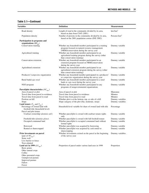
METHODS AND MODELS 31<br />
Table 3.1—Cont<strong>in</strong>ued<br />
Variables Def<strong>in</strong>ition Measurement<br />
Road density Length of road <strong>in</strong> <strong>the</strong> community divided by its area, km/km 2<br />
based on data from CIAT (2001)<br />
Population density Number of persons <strong>in</strong> <strong>the</strong> community divided by its area, Persons/km 2<br />
based on <strong>the</strong> 2001 population census (INE 2002)<br />
Participation <strong>in</strong> programs <strong>and</strong><br />
organizations (SC ht<br />
)<br />
Conservation tra<strong>in</strong><strong>in</strong>g Whe<strong>the</strong>r any household member participated <strong>in</strong> a tra<strong>in</strong><strong>in</strong>g Dummy variable<br />
program focused on natural resource management<br />
(NRM)/conservation dur<strong>in</strong>g <strong>the</strong> survey year<br />
Agricultural tra<strong>in</strong><strong>in</strong>g Whe<strong>the</strong>r any household member participated <strong>in</strong> an Dummy variable<br />
agricultural tra<strong>in</strong><strong>in</strong>g program dur<strong>in</strong>g <strong>the</strong> survey (o<strong>the</strong>r<br />
than conservation tra<strong>in</strong><strong>in</strong>g)<br />
Conservation extension Whe<strong>the</strong>r any household member participated <strong>in</strong> an Dummy variable<br />
extension program focused on NRM/conservation<br />
dur<strong>in</strong>g <strong>the</strong> survey year<br />
Agricultural extension Whe<strong>the</strong>r any household member participated <strong>in</strong> an Dummy variable<br />
agricultural extension program dur<strong>in</strong>g <strong>the</strong> survey (o<strong>the</strong>r<br />
than conservation tra<strong>in</strong><strong>in</strong>g)<br />
Producers’/campes<strong>in</strong>o organization Whe<strong>the</strong>r any household member participated <strong>in</strong> a producers’ Dummy variable<br />
or campes<strong>in</strong>o organization dur<strong>in</strong>g <strong>the</strong> survey year<br />
<strong>Rural</strong> bank/caja rural Whe<strong>the</strong>r any household member participated <strong>in</strong> a rural Dummy variable<br />
bank or caja rural dur<strong>in</strong>g <strong>the</strong> survey year<br />
NGO program Whe<strong>the</strong>r any household member participated <strong>in</strong> any Dummy variable<br />
programs of nongovernmental organizations<br />
Parcel/plot characteristics (NC hpt<br />
)<br />
Area of parcel or plot Area of parcel or plot Manzanas<br />
Travel time from parcel to residence Travel time from parcel to residence M<strong>in</strong>utes<br />
Travel time from parcel to road Travel time from parcel to road M<strong>in</strong>utes<br />
Position on hill Whe<strong>the</strong>r plot is at <strong>the</strong> bottom, top, or side of a hill Dummy variables<br />
Slope Slope category of <strong>the</strong> plot (flat, moderate, steep) Dummy variables<br />
L<strong>and</strong> tenure (T ht<br />
<strong>and</strong> T hpt<br />
)<br />
Percentage of owned l<strong>and</strong> with Household-level variable for share of owned l<strong>and</strong> with title Percentage<br />
freehold title (household level)<br />
Parcel <strong>and</strong> plot tenure<br />
Usufruct ownership (dom<strong>in</strong>io util) Whe<strong>the</strong>r parcel/plot is owned with usufruct tenure rights Dummy variable<br />
only<br />
Freehold title (dom<strong>in</strong>io pleno) Whe<strong>the</strong>r parcel/plot is owned with full freehold tenure Dummy variable<br />
Occupied communal l<strong>and</strong> Whe<strong>the</strong>r parcel/plot is occupied communal l<strong>and</strong> without Dummy variable<br />
formal rights<br />
Borrowed Whe<strong>the</strong>r parcel/plot was acquired by borrow<strong>in</strong>g Dummy variable<br />
Rented or sharecropped Whe<strong>the</strong>r parcel/plot was acquired by cash rental or Dummy variable<br />
sharecropp<strong>in</strong>g<br />
Prior <strong>in</strong>vestments on parcel Whe<strong>the</strong>r <strong>in</strong>vestments existed on <strong>the</strong> parcel at <strong>the</strong> beg<strong>in</strong>n<strong>in</strong>g Dummy variables<br />
(part of NC hpt<br />
)<br />
of <strong>the</strong> survey year<br />
Stone wall<br />
Live barrier or fence<br />
Trees planted<br />
L<strong>and</strong> use <strong>in</strong> 1999 (LU hpt<br />
) Proportion of parcel under various l<strong>and</strong> uses <strong>in</strong> 1999 Proportion<br />
Basic gra<strong>in</strong>s<br />
O<strong>the</strong>r annual crops<br />
Coffee<br />
O<strong>the</strong>r perennial crops<br />
Unimproved pasture<br />
Improved pasture<br />
Fallow<br />
Forest