Kent Design - Technical Appendix - Kent County Council
Kent Design - Technical Appendix - Kent County Council
Kent Design - Technical Appendix - Kent County Council

Create successful ePaper yourself
Turn your PDF publications into a flip-book with our unique Google optimized e-Paper software.
design<br />
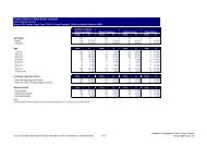
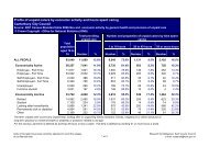
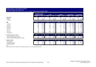
2.5.1 GUIDANCE FOR THE TABLE OF STANDARDS<br />
The table combines the minimum acceptable standards necessary for<br />
highway layout design and reflects standards that are published in<br />
Residential Roads and Footpaths - Layout Considerations -<br />
<strong>Design</strong> Bulletin 32 (Second Edition), published by the DETR.<br />
Interpretation of the standards will rest with the Area Office or<br />
District Development Control Officer.<br />
The table differentiates between environments that are dominated<br />
by vehicles and environments where the intention is for them to be<br />
dominated by pedestrians and cyclists.<br />
Safety for pedestrians, cyclists and vehicle users is paramount in<br />
layout design and advice must be sought for appropriate level of signs<br />
and lines in low speed, pedestrian and cycle friendly environments.<br />
The table describes the type of traffic that is likely to use the<br />
particular road type. The table is split into three sections:<br />
Section 1 determines the basic highway requirements for the<br />
particular road type and the traffic it carries, namely the road width<br />
and target speed;<br />
Section 2 details the geometric standards necessary to achieve the<br />
target speed and create a safe environment;<br />
Section 3 describes the additional requirements or allowances for the<br />
particular road type.<br />
The Target Speed concept is the context for the geometric standards<br />
and therefore standards are based on road speed not road type.<br />
Lower target speeds of 10 or 15 mph could be used in certain road<br />
types and target speeds for certain sites may well be specified in the<br />
local plan.<br />
Road widths are given for the carriageway in vehicle dominated<br />
environments, but are given as the ‘trackway’ width in pedestrian<br />
and cycle dominated environments.<br />
Trackways are described in ‘Places, Streets and Movement’,<br />
Companion Guide to <strong>Design</strong> Bulletin 32, Residential Roads and<br />
Footpaths, published by the DETR and are the widths that are to be<br />
kept clear for traffic within an overall, variable highway width that<br />
could allow for on-street casual parking or community areas through<br />
which slow moving traffic might pass.<br />
There is the need to maintain access for service vehicles to<br />
properties although provision for them should not be the overriding<br />
factor in layout design.<br />
There may be a need to allow access for buses into or adjacent to<br />
developments although this should not be an overriding factor in<br />
layout design. Narrow widths could be maintained by putting buses<br />
on looped routes to avoid them passing each other.<br />
Access for utilities’ works and highways maintenance needs to be<br />
considered in the layout design.<br />
Major Access Roads can be single carriageway circuit roads (with one<br />
point of access) or alternatively loop roads (with two points of access).<br />
Circuit roads shall have a short connecting length between the circuit<br />
and the point of access together with an alternative means of access.<br />
The needs of the emergency services must be taken into account in<br />
layout design. If the number of dwellings served by a cul-de-sac<br />
exceeds 50 or where a major access road is designed as a circuit road,<br />
then an alternative means of access for cyclists and pedestrians, which<br />
could also be used for vehicular access in the event of an emergency,<br />
may be required. 3m wide access widths must open out to a 3.7m<br />
wide envelope to allow for fire appliance doors to fully open.<br />
In narrow roads provided with passing places, care needs to be taken<br />
in differentiating them from parking places.<br />
34<br />
<strong>Kent</strong><br />
<strong>Design</strong><br />
Generally, the developer should be able to demonstrate how a layout<br />
can work without relying on a prescribed standard for every detail.<br />
In environments where overall highway width varies but a trackway<br />
provides for movement, casual parking could be allowed in the<br />
spaces outside the trackway.<br />
The need for casual parking should be assessed and provided for in the<br />
layout. The provision for casual parking would need to be designed in<br />
a way that prevents abuse of the space provided for parking.<br />
Maximum road lengths are introduced as a way of ensuring that<br />
speeds do not exceed the target speed of the road without the need<br />
for speed restraint. These maximum road lengths would enable a<br />
layout to be designed that achieves target speeds without the need<br />
for speed restraint devices.<br />
If road lengths are longer than those stated for the target speed, then<br />
speed restraint devices would have to be introduced in order to<br />
achieve the target speeds.<br />
The table includes standards for junction ‘x’ and ‘y’ distances,<br />
junction spacings and radii.<br />
In the third section of the table, footway widths should be based on<br />
their usage in accordance with the type of road, rather than a<br />
standard, but must always remain of sufficient width to<br />
accommodate the mobility impaired and services, as the highway<br />
authority will not allow services to be provided beneath the<br />
carriageway. Footway widths could be reduced to 1.5m in rural<br />
areas, for example, in keeping with the surrounding location.<br />
Verges are required to separate pedestrians and vehicles in district<br />
and local distributor roads. Margins are only required in shared<br />
surfaces to accommodate services where a footway is not provided,<br />
and for vehicle overhangs where a footway is not provided. The<br />
minimum margin width is 1.5m but this may need to be widened<br />
where necessary to accommodate services.<br />
Frontager access is allowed on all road types except for the district<br />
distributors.<br />
Streetlighting is mandatory on district, local distributor roads and<br />
shared surface environments.<br />
2.6 DRAINAGE<br />
2.6.1 DESIGN OF SURFACE WATER DRAINAGE SYSTEMS<br />
2.6.1.1 GENERAL<br />
Surface water from the highway shall be collected by means of gullies<br />
and gully connections, channel and grating systems or combined<br />
drainage and kerb systems and shall be discharged through pipes of<br />
not less than 150mm diameter to an adequate sewer, highway drain,<br />
ditch or watercourse or, where sufficient permeability is obtainable,<br />
to soakaways. Where a ditch or watercourse may become<br />
overloaded by additional run-off, regulation of the discharge by<br />
means of a balancing container or pond may be required. The EA<br />
should be consulted regarding outfall and discharge criteria.<br />
Where it is proposed to connect to an existing or proposed public<br />
sewer, the consent of the appropriate Drainage Undertaker will be<br />
required, and the Engineer will require evidence that such consent<br />
has been obtained prior to approving the drainage design.<br />
2.6.1.2 DESIGN OF HIGHWAY DRAINAGE SYSTEM<br />
The ‘Rational (Lloyd-Davies)’ method shall be used for the design of<br />
highway drainage as set out in Road Note 35 ‘A guide for<br />
engineers to the design of storm sewer systems’, published by<br />
HMSO and used in conjunction with the ‘Tables for the hydraulic<br />
design of pipes and sewers (5th Edition)’, published for<br />
Hydraulics Research by Thomas Telford Ltd, except for small<br />
developments with less than 1000m 2 run-off, where a 150mm