Appendix F Detailed Cover Type Tables - USDA Rural Development
Appendix F Detailed Cover Type Tables - USDA Rural Development
Appendix F Detailed Cover Type Tables - USDA Rural Development

Create successful ePaper yourself
Turn your PDF publications into a flip-book with our unique Google optimized e-Paper software.
Bemidji – Grand Rapids<br />
Biological Assessment and Evaluation<br />
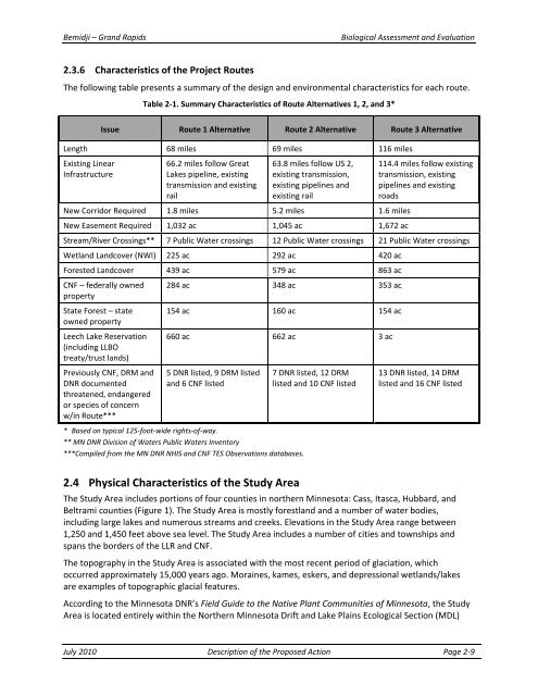
2.3.6 Characteristics of the Project Routes<br />
The following table presents a summary of the design and environmental characteristics for each route.<br />
Table 2‐1. Summary Characteristics of Route Alternatives 1, 2, and 3*<br />
Issue Route 1 Alternative Route 2 Alternative Route 3 Alternative<br />
Length 68 miles 69 miles 116 miles<br />
Existing Linear<br />
Infrastructure<br />
66.2 miles follow Great<br />
Lakes pipeline, existing<br />
transmission and existing<br />
rail<br />
63.8 miles follow US 2,<br />
existing transmission,<br />
existing pipelines and<br />
existing rail<br />
New Corridor Required 1.8 miles 5.2 miles 1.6 miles<br />
New Easement Required 1,032 ac 1,045 ac 1,672 ac<br />
114.4 miles follow existing<br />
transmission, existing<br />
pipelines and existing<br />
roads<br />
Stream/River Crossings** 7 Public Water crossings 12 Public Water crossings 21 Public Water crossings<br />
Wetland Landcover (NWI) 225 ac 292 ac 420 ac<br />
Forested Landcover 439 ac 579 ac 863 ac<br />
CNF – federally owned<br />
property<br />
State Forest – state<br />
owned property<br />
Leech Lake Reservation<br />
(including LLBO<br />
treaty/trust lands)<br />
Previously CNF, DRM and<br />
DNR documented<br />
threatened, endangered<br />
or species of concern<br />
w/in Route***<br />
284 ac 348 ac 353 ac<br />
154 ac 160 ac 154 ac<br />
660 ac 662 ac 3 ac<br />
5 DNR listed, 9 DRM listed<br />
and 6 CNF listed<br />
* Based on typical 125‐foot‐wide rights‐of‐way.<br />
** MN DNR Division of Waters Public Waters Inventory<br />
***Compiled from the MN DNR NHIS and CNF TES Observations databases.<br />
7 DNR listed, 12 DRM<br />
listed and 10 CNF listed<br />
13 DNR listed, 14 DRM<br />
listed and 16 CNF listed<br />
2.4 Physical Characteristics of the Study Area<br />
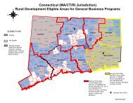
The Study Area includes portions of four counties in northern Minnesota: Cass, Itasca, Hubbard, and<br />
Beltrami counties (Figure 1). The Study Area is mostly forestland and a number of water bodies,<br />
including large lakes and numerous streams and creeks. Elevations in the Study Area range between<br />
1,250 and 1,450 feet above sea level. The Study Area includes a number of cities and townships and<br />
spans the borders of the LLR and CNF.<br />
The topography in the Study Area is associated with the most recent period of glaciation, which<br />
occurred approximately 15,000 years ago. Moraines, kames, eskers, and depressional wetlands/lakes<br />
are examples of topographic glacial features.<br />
According to the Minnesota DNR’s Field Guide to the Native Plant Communities of Minnesota, the Study<br />
Area is located entirely within the Northern Minnesota Drift and Lake Plains Ecological Section (MDL)<br />
July 2010 Description of the Proposed Action Page 2‐9