

Standard Format Tentative Budget Submission - Southwest Florida ...
Standard Format Tentative Budget Submission - Southwest Florida ...
Standard Format Tentative Budget Submission - Southwest Florida ...

Create successful ePaper yourself
Turn your PDF publications into a flip-book with our unique Google optimized e-Paper software.
IV. Program Allocations<br />
1.2 Research, Data Collection, Analysis and Monitoring – Activities that support district water<br />
management planning, restoration, and preservation efforts, including water quality monitoring, data<br />
collection and evaluation, and research.<br />
District Description<br />
This activity consists of District-managed and outsourced data collection, data analysis, and basic<br />
research. Support is provided to state-mandated efforts such as coordinated land use/land cover<br />
mapping and water quality monitoring. The Regional Observation and Monitor-well Program (ROMP)<br />
provides the technical characterization of the District’s ground water resources, constructs long-term<br />
ground water level and quality monitoring sites, and performs detailed hydrogeologic investigations in<br />
support of Water Resource Assessment Projects (WRAPs) and other water resource management<br />
efforts.<br />
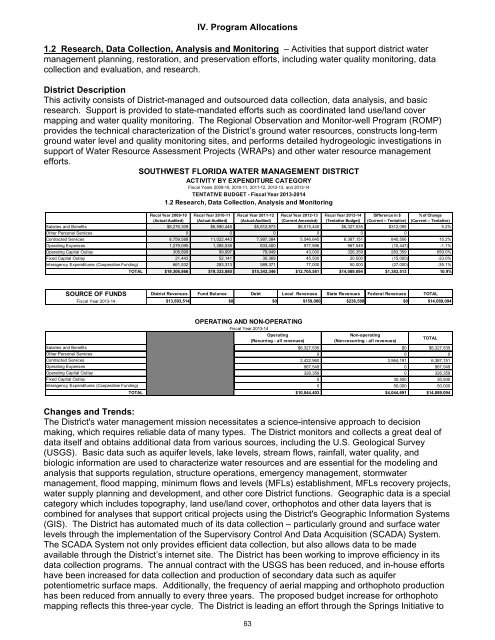
SOUTHWEST FLORIDA WATER MANAGEMENT DISTRICT<br />
ACTIVITY BY EXPENDITURE CATEGORY<br />
Fiscal Years 2009-10, 2010-11, 2011-12, 2012-13, and 2013-14<br />
TENTATIVE BUDGET - Fiscal Year 2013-2014<br />
1.2 Research, Data Collection, Analysis and Monitoring<br />
Fiscal Year 2009-10<br />
(Actual-Audited)<br />
Fiscal Year 2010-11<br />
(Actual-Audited)<br />
Fiscal Year 2011-12<br />
(Actual-Audited)<br />
Fiscal Year 2012-13<br />
(Current Amended)<br />
Fiscal Year 2013-14<br />
(<strong>Tentative</strong> <strong>Budget</strong>)<br />
Difference in $<br />
(Current -- <strong>Tentative</strong>)<br />
% of Change<br />
(Current -- <strong>Tentative</strong>)<br />
Salaries and Benefits $8,276,309 $6,590,448 $5,812,873 $6,015,440 $6,327,535 $312,095 5.2%<br />
Other Personal Services 0 0 0 0 0 0<br />
Contracted Services 8,759,588 11,022,443 7,997,384 5,546,645 6,387,151 840,506 15.2%<br />
Operating Expenses 1,279,095 1,285,538 833,400 977,996 967,549 (10,447) -1.1%<br />
Operating Capital Outlay 308,899 99,997 79,949 43,000 326,359 283,359 659.0%<br />
Fixed Capital Outlay 21,443 52,141 30,369 45,500 30,500 (15,000) -33.0%<br />
Interagency Expenditures (Cooperative Funding) 661,532 283,313 589,371 77,000 50,000 (27,000) -35.1%<br />
TOTAL $19,306,866 $19,333,880 $15,343,346 $12,705,581 $14,089,094 $1,383,513 10.9%<br />
SOURCE OF FUNDS District Revenues Fund Balance Debt Local Revenues State Revenues Federal Revenues TOTAL<br />
Fiscal Year 2013-14 $13,693,514 $0 $0 $159,000 $236,580 $0 $14,089,094<br />
OPERATING AND NON-OPERATING<br />
Fiscal Year 2013-14<br />
Operating<br />
(Recurring - all revenues)<br />
Non-operating<br />
(Non-recurring - all revenues)<br />
Salaries and Benefits $6,327,535 $0<br />
$6,327,535<br />
Other Personal Services 0 0<br />
0<br />
Contracted Services 2,422,960 3,964,191<br />
6,387,151<br />
Operating Expenses 967,549 0<br />
967,549<br />
Operating Capital Outlay 326,359 0<br />
326,359<br />
Fixed Capital Outlay 0 30,500<br />
30,500<br />
Interagency Expenditures (Cooperative Funding) 0 50,000<br />
50,000<br />
TOTAL $10,044,403 $4,044,691 $14,089,094<br />
TOTAL<br />
Changes and Trends:<br />
The District's water management mission necessitates a science-intensive approach to decision<br />
making, which requires reliable data of many types. The District monitors and collects a great deal of<br />
data itself and obtains additional data from various sources, including the U.S. Geological Survey<br />
(USGS). Basic data such as aquifer levels, lake levels, stream flows, rainfall, water quality, and<br />
biologic information are used to characterize water resources and are essential for the modeling and<br />
analysis that supports regulation, structure operations, emergency management, stormwater<br />
management, flood mapping, minimum flows and levels (MFLs) establishment, MFLs recovery projects,<br />
water supply planning and development, and other core District functions. Geographic data is a special<br />
category which includes topography, land use/land cover, orthophotos and other data layers that is<br />
combined for analyses that support critical projects using the District's Geographic Information Systems<br />
(GIS). The District has automated much of its data collection – particularly ground and surface water<br />
levels through the implementation of the Supervisory Control And Data Acquisition (SCADA) System.<br />
The SCADA System not only provides efficient data collection, but also allows data to be made<br />
available through the District’s internet site. The District has been working to improve efficiency in its<br />
data collection programs. The annual contract with the USGS has been reduced, and in-house efforts<br />
have been increased for data collection and production of secondary data such as aquifer<br />
potentiometric surface maps. Additionally, the frequency of aerial mapping and orthophoto production<br />
has been reduced from annually to every three years. The proposed budget increase for orthophoto<br />
mapping reflects this three-year cycle. The District is leading an effort through the Springs Initiative to<br />
63


