

Metropolitan Coal Project Independent ... - Peabody Energy
Metropolitan Coal Project Independent ... - Peabody Energy
Metropolitan Coal Project Independent ... - Peabody Energy

Create successful ePaper yourself
Turn your PDF publications into a flip-book with our unique Google optimized e-Paper software.
<strong>Metropolitan</strong> <strong>Coal</strong> <strong>Independent</strong> Environmental Audit<br />
Condition<br />
No.<br />
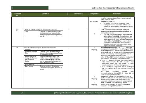
3/1 Table 1: Subsidence Impact Performance Measures<br />
Cliffs<br />
Less than 3% of the total length of cliffs<br />
(and associated overhangs within the<br />
mining area) experience mining-induced<br />
rock fall.<br />
3/1 Table 1: Subsidence Impact Performance Measures<br />
Heritage<br />
Aboriginal Heritage<br />
Sites<br />
Items of historical or<br />
heritage significance at<br />
the Garrawarra<br />
Centre<br />
Built Features<br />
Built Features<br />
Condition Verification Compliance Comments<br />
Less than 10% of Aboriginal heritage<br />
sites within the mining area are affected<br />
by subsidence impacts.<br />
Negligible damage (that is fine or<br />
hairline cracks that do not require<br />
repair), unless the owner of the item<br />
and the appropriate heritage authority<br />
agree otherwise in writing<br />
Safe, serviceable and repairable,<br />
unless the owner agrees otherwise in<br />
writing.<br />
Not activated<br />
C<br />
C<br />
Ongoing<br />
C<br />
Ongoing<br />
C<br />
Ongoing<br />
No other endangered populations were recorded<br />
within the study area.<br />
Swamps 76, 77 & 92 –<br />
Long-walls 20-22 do not undermine these<br />
swamps and it was reported that there is no<br />
intention to mine beneath these swamps at this<br />
time.<br />
Cliffs - Less than 3% of the total length of cliffs (and<br />
associated overhangs within the mining area) experience<br />
mining-induced rock fall.<br />
Five cliffs and overhangs have been identified<br />
within 600m of LW 20-22. These features are<br />
subject to monthly monitoring during extraction<br />
(within 400m of the sites). Similarly steep slopes<br />
within 600m of LW 20-22 have been routinely<br />
monitored during extraction. No subsidence<br />
related impacts have been observed in steep<br />
slopes, cliff lines or overhangs.<br />
Aboriginal Heritage Sites - all Aboriginal<br />
heritage sites located within the 35º Angle of Draw<br />
of the long-walls 3-6 months after the completion<br />
of the long-wall, by an archaeologist experienced<br />
in rock art recording and management and an<br />
Aboriginal stakeholder representative.<br />
In the 2010 and 2011 period monitoring of Aboriginal<br />
heritage sites, two affected sites were identified:<br />
FRC 12 - weathering to the Darmulan engraving<br />
was observed during the 2010 survey. This<br />
weathering effect did not appear to have<br />
deteriorated in the 2011 monitoring survey.<br />
FRC 139 showed a significant level of cracking of<br />
the rock platform during the 2011 site monitoring<br />
survey.<br />
All other Aboriginal heritage sites<br />
surveyed/monitored during 2011 (14 sites) did not<br />
show any changes/deterioration.<br />
Garrawarra Centre - the Garrawarra Complex is<br />
located more than 3 km from long-walls 20-22 and at<br />
this distance no measurable systematic or nonsystematic<br />
subsidence movements are anticipated.<br />
Built Features – no subsidence impact<br />
performance measure for built features was<br />
exceeded during 2009 and 2011.<br />
vii<br />
| <strong>Metropolitan</strong> <strong>Coal</strong> <strong>Project</strong> Approval, Environment Protection License and Consolidated Mining Lease


