The Border of Farming and the Cultural Markers - Nordlige Verdener
The Border of Farming and the Cultural Markers - Nordlige Verdener
The Border of Farming and the Cultural Markers - Nordlige Verdener

Create successful ePaper yourself
Turn your PDF publications into a flip-book with our unique Google optimized e-Paper software.
46<br />
±<br />
±<br />
1<br />
15 14<br />
<br />
16<br />
1 18<br />
13<br />
17<br />
<br />
15 14<br />
16 18<br />
13<br />
17<br />
12<br />
10<br />
12<br />
7 9<br />
10<br />
2<br />
6<br />
11<br />
7 9<br />
11<br />
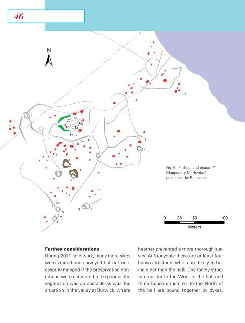
Fig. 6: Pinhoull<strong>and</strong> phase 1<br />
Mapped by M. Hoydal/<br />
processed by P. Jensen.<br />
2<br />
6<br />
19<br />
3<br />
5 8<br />
19<br />
4<br />
4<br />
3<br />
5 8<br />
0 25 50 100<br />
Meters<br />
0 25 50<br />
Meters<br />
Fur<strong>the</strong>r considerations<br />
During 2011 field work, many more sites<br />
were visited <strong>and</strong> surveyed but not necessarily<br />
mapped if <strong>the</strong> preservation conditions<br />
were estimated to be poor or <strong>the</strong><br />
vegetation was an obstacle as was <strong>the</strong><br />
situation in <strong>the</strong> valley at Burwick, where<br />
hea<strong>the</strong>r prevented a more thorough survey.<br />
At Stanydale <strong>the</strong>re are at least four<br />
house structures which are likely to being<br />
older than <strong>the</strong> hall. One lonely structure<br />
not far to <strong>the</strong> West <strong>of</strong> <strong>the</strong> hall <strong>and</strong><br />
three house structures to <strong>the</strong> North <strong>of</strong><br />
<strong>the</strong> hall are bound toge<strong>the</strong>r by dykes.