The Border of Farming and the Cultural Markers - Nordlige Verdener
The Border of Farming and the Cultural Markers - Nordlige Verdener
The Border of Farming and the Cultural Markers - Nordlige Verdener

Create successful ePaper yourself
Turn your PDF publications into a flip-book with our unique Google optimized e-Paper software.
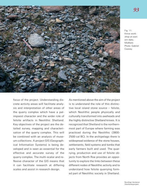
93<br />
Fig. 11:<br />
Knive workshop<br />
at eastern<br />
dyke,<br />
Midfield.<br />
Photo: Gabriel<br />
Cooney<br />
focus <strong>of</strong> <strong>the</strong> project. Underst<strong>and</strong>ing discrete<br />
activity areas will facilitate analysis<br />
<strong>and</strong> interpretation <strong>of</strong> o<strong>the</strong>r areas <strong>of</strong><br />
<strong>the</strong> quarry complex which have a palimpsest<br />
character <strong>and</strong> <strong>the</strong> wider role <strong>of</strong><br />
felsite artifacts in Neolithic Shetl<strong>and</strong>.<br />
Key objectives <strong>of</strong> <strong>the</strong> project are <strong>the</strong> detailed<br />
survey, mapping <strong>and</strong> characterisation<br />
<strong>of</strong> <strong>the</strong> quarry complex. This will<br />
be combined with an analysis <strong>of</strong> museum<br />
collections. A project GIS (Geographical<br />
Information Systems) is being developed<br />
<strong>and</strong> is seen as essential for <strong>the</strong><br />
effective <strong>and</strong> accurate survey <strong>of</strong> <strong>the</strong><br />
quarry complex. <strong>The</strong> multi-scalar <strong>and</strong> reflexive<br />
character <strong>of</strong> <strong>the</strong> GIS means that<br />
it can facilitate research at differing<br />
scales <strong>and</strong> assist in research design.<br />
As mentioned above <strong>the</strong> aim <strong>of</strong> <strong>the</strong> project<br />
is to underst<strong>and</strong> <strong>the</strong> role <strong>of</strong> this distinctive<br />
local isl<strong>and</strong> stone source – felsite,<br />
which Neolithic people physically <strong>and</strong><br />
culturally transformed into axeheads <strong>and</strong><br />
<strong>the</strong> highly distinctive Shetl<strong>and</strong> knives. It is<br />
recognized that Shetl<strong>and</strong> is <strong>the</strong> nor<strong>the</strong>rnmost<br />
part <strong>of</strong> Europe where farming was<br />
practiced during <strong>the</strong> Neolithic (3800-<br />
2500 cal BC). In <strong>the</strong> archipelago <strong>the</strong>re is<br />
widespread evidence <strong>of</strong> <strong>the</strong> stone houses,<br />
settlements, field systems <strong>and</strong> tombs that<br />
early farmers built <strong>and</strong> used. <strong>The</strong> quarrying,<br />
production <strong>and</strong> use <strong>of</strong> felsite objects<br />
from North Roe provides an opportunity<br />
to explore <strong>the</strong> links between <strong>the</strong>se<br />
different nodes <strong>of</strong> Neolithic activity <strong>and</strong> to<br />
underst<strong>and</strong> how felsite quarrying formed<br />
part <strong>of</strong> Neolithic society in Shetl<strong>and</strong>.<br />
<strong>Nordlige</strong> <strong>Verdener</strong><br />
Shetl<strong>and</strong>sprojekt