Final Technical Report - weADAPT
Final Technical Report - weADAPT
Final Technical Report - weADAPT
- No tags were found...

Create successful ePaper yourself
Turn your PDF publications into a flip-book with our unique Google optimized e-Paper software.
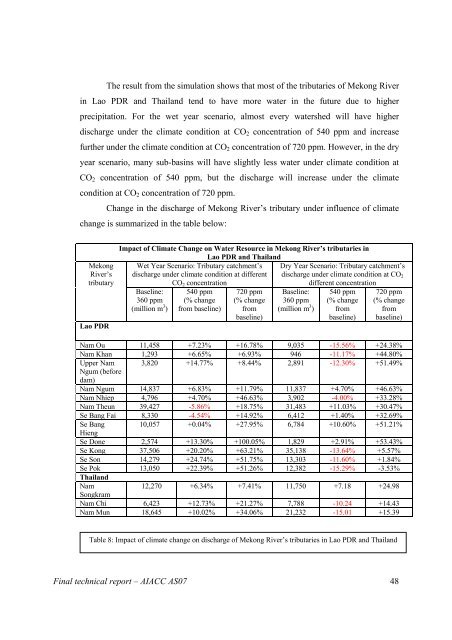
The result from the simulation shows that most of the tributaries of Mekong River<br />
in Lao PDR and Thailand tend to have more water in the future due to higher<br />
precipitation. For the wet year scenario, almost every watershed will have higher<br />
discharge under the climate condition at CO 2 concentration of 540 ppm and increase<br />
further under the climate condition at CO 2 concentration of 720 ppm. However, in the dry<br />
year scenario, many sub-basins will have slightly less water under climate condition at<br />
CO 2 concentration of 540 ppm, but the discharge will increase under the climate<br />
condition at CO 2 concentration of 720 ppm.<br />
Change in the discharge of Mekong River’s tributary under influence of climate<br />
change is summarized in the table below:<br />
Mekong<br />
River’s<br />
tributary<br />
Lao PDR<br />
Impact of Climate Change on Water Resource in Mekong River’s tributaries in<br />
Lao PDR and Thailand<br />
Wet Year Scenario: Tributary catchment’s Dry Year Scenario: Tributary catchment’s<br />
discharge under climate condition at different discharge under climate condition at CO 2<br />
CO 2 concentration<br />
different concentration<br />
Baseline:<br />
360 ppm<br />
(million m 3 )<br />
540 ppm<br />
(% change<br />
from baseline)<br />
720 ppm<br />
(% change<br />
from<br />
baseline)<br />
Baseline:<br />
360 ppm<br />
(million m 3 )<br />
540 ppm<br />
(% change<br />
from<br />
baseline)<br />
720 ppm<br />
(% change<br />
from<br />
baseline)<br />
Nam Ou 11,458 +7.23% +16.78% 9,035 -15.56% +24.38%<br />
Nam Khan 1,293 +6.65% +6.93% 946 -11.17% +44.80%<br />
Upper Nam 3,820 +14.77% +8.44% 2,891 -12.30% +51.49%<br />
Ngum (before<br />
dam)<br />
Nam Ngum 14,837 +6.83% +11.79% 11,837 +4.70% +46.63%<br />
Nam Nhiep 4,796 +4.70% +46.63% 3,902 -4.00% +33.28%<br />
Nam Theun 39,427 -5.86% +18.75% 31,483 +11.03% +30.47%<br />
Se Bang Fai 8,330 -4.54% +14.92% 6,412 +1.40% +32.69%<br />
Se Bang 10,057 +0.04% +27.95% 6,784 +10.60% +51.21%<br />
Hieng<br />
Se Done 2,574 +13.30% +100.05% 1,829 +2.91% +53.43%<br />
Se Kong 37,506 +20.20% +63.21% 35,138 -13.64% +5.57%<br />
Se Son 14,279 +24.74% +51.75% 13,303 -11.60% +1.84%<br />
Se Pok 13,050 +22.39% +51.26% 12,382 -15.29% -3.53%<br />
Thailand<br />
Nam<br />
12,270 +6.34% +7.41% 11,750 +7.18 +24.98<br />
Songkram<br />
Nam Chi 6,423 +12.73% +21.27% 7,788 -10.24 +14.43<br />
Nam Mun 18,645 +10.02% +34.06% 21,232 -15.01 +15.39<br />
Table 8: Impact of climate change on discharge of Mekong River’s tributaries in Lao PDR and Thailand<br />
<strong>Final</strong> technical report – AIACC AS07 48