

Final Baseline Hydrology Report - October 2012 - Urban Drainage ...
Final Baseline Hydrology Report - October 2012 - Urban Drainage ...
Final Baseline Hydrology Report - October 2012 - Urban Drainage ...

Create successful ePaper yourself
Turn your PDF publications into a flip-book with our unique Google optimized e-Paper software.
Sanderson Gulch Major <strong>Drainage</strong>way Plan<br />
<strong>Baseline</strong> <strong>Hydrology</strong> <strong>Report</strong> <strong>October</strong> <strong>2012</strong><br />
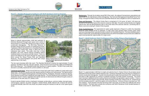
Reach 6 – Sheridan Boulevard to Confluence with North Sanderson Gulch (Lakewood)<br />
Maintenance. Through the privately owned Bit-O-Sea reach, the adjacent homeowners associations are<br />
responsible for the maintenance of the drainageway. The improved drainageway for the White Fence Farm<br />
Filing 1 through the Wilson Family Park and Clairefield Reservoir area is eligible for UDFCD maintenance.<br />
Parks and Recreation. The Wilson Family Park is comprised of 13.16 acres, of which 1.62 acres are<br />
devoted to the permanent pool of the reservoir, based on GIS data. The park is predominantly non-irrigated<br />
natural area, with the bike/pedestrian path on the north side of the channel/ reservoir, connecting with S.<br />
Manor Lane and crossing S. Harlan Circle at grade.<br />
Water Quality/Detention. The opportunity for water quality treatment in Reach 6 is within the Clairefield<br />
Reservoir which already serves as detention. A major storm drain tributary inflow crosses under Jewell<br />
Avenue to discharge down a grouted boulder rundown into Clairefield Reservoir. The future ballfields area in<br />
Wilson Family Park could potentially be graded lower to be within the floodplain and provide some additional<br />
peak shaving detention opportunities in a major event.<br />
Reach 6 extends approximately 3,500 feet upstream of<br />
Sheridan Boulevard through open space and a series of<br />
three ponds to S. Harlan Drive where it re-enters a narrow,<br />
constructed drainageway. The Bit-O-Sea Reservoir is<br />
privately owned and has no public or maintenance access.<br />
Upstream of Bit-O-Sea Reservoir is Clairefield Reservoir<br />
and the Wilson Family Park, which is within the City of<br />
Lakewood open space. This public area has a broad<br />
floodplain and more natural channel conditions without<br />
hardened banks or structures and little incision. There is a<br />
gravel trail adjacent to the gulch through the open space<br />
which serves the Wilson Family Park and Clairefield<br />
Reservoir. The broad floodplain and ponds offer unique<br />
opportunities in this reach.<br />
Wilson Family Park at S. Harlan Circle. This<br />
area has been improved and includes a<br />
recent LOMR.<br />
The two road crossings within this reach. The Sheridan Boulevard crossing has approximately 10-year<br />
capacity. The Manor Lane has 100-year capacity. Drop structures exist only at the outlets of Clairefield and<br />
Bit-O-Sea Reservoir. The Clairefield outlet drop structure is in good condition. The Bit-O-Sea outlet drop<br />
structure is privately owned and its current condition is unknown.<br />
Landscape and Ecology. Wilson Family Park has a large open water body in addition to a large native open<br />
space area. The gulch is heavily lined with riparian species of willows and cottonwoods. The upland portion<br />
of the park is non-irrigated dryland grasses consisting of grama, wheatgrass, dropseed, and fescue species.<br />
Shrub species include Green rabbitbrush and sage species. The short distance to the confluence of North<br />
Sanderson Gulch is heavily vegetated with riparian species of cottonwood and willows through a series of<br />
ponds west of the east loop of S. Harlan Circle.<br />
Invasive species (thistle, kochia, smartweed, bindweed, prickly lettuce, common mallow, barnyard grass,<br />
Johnsongrass, pigweed, rag weed, halogeton, redstem filaree, alfalfa, Siberian elm, Chinese elm and the<br />
occasional Russian olive and curly dock) are present along the channel as well as in the upland grass<br />
areas.<br />
Reach 7 – North Sanderson Gulch Confluence to Green Gables Entrance Road (Lakewood)<br />
Reach 7 is approximately 2,000 feet in length and extends from S. Harlan Circle to the privately owned<br />
Shwayder Pond at the Green Gables entrance road. Except for Shwayder Pond, the reach is contained in a<br />
narrow constructed drainageway. A public trail along the gulch exists only downstream of W. Jewell Avenue<br />
and there is little opportunity to continue it upstream because of private property ownership. The entire<br />
reach has been stabilized and the existing channel and facilities are generally in good condition. There is<br />
currently little need for further improvements. Road crossings consist of W. Harlan Circle, W. Jewell Avenue<br />
and the privately owned W. Lake Drive gated community entrance. All three of these crossings have 100-<br />
year capacity. Three grouted rock drop structures exist in the reach, all of which are relatively new and in<br />
good condition. The reach also contains the confluence with North Sanderson Gulch located between S.<br />
Harlan Circle and W. Jewell Avenue.<br />
8


