

Final Baseline Hydrology Report - October 2012 - Urban Drainage ...
Final Baseline Hydrology Report - October 2012 - Urban Drainage ...
Final Baseline Hydrology Report - October 2012 - Urban Drainage ...

You also want an ePaper? Increase the reach of your titles
YUMPU automatically turns print PDFs into web optimized ePapers that Google loves.
Sanderson Gulch Major <strong>Drainage</strong>way Plan<br />
<strong>Baseline</strong> <strong>Hydrology</strong> <strong>Report</strong><br />
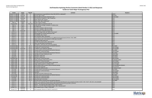
Draft <strong>Baseline</strong> <strong>Hydrology</strong> Review Comments dated <strong>October</strong> 9, <strong>2012</strong> and Responses<br />
Sanderson Gulch Major <strong>Drainage</strong>way Plan<br />
Ocotber <strong>2012</strong><br />
Section Author Page No. Comment Response<br />
Section 2.3, RNS3 UDFCD 9 Verify maintenance responsibilities for Reach NS2 (UDFCD or Lakewood?) UDFCD<br />
Section 2.3, RNS3 Lakewood 9 Add "also" after "would" Rewritten<br />
Section 2.3, RNS4 Denver 9 Add map labels for all streets referenced in text Streets added<br />
Section 2.3, RNS4 Lakewood 9 Add "just east of S. Balsam Ct." after "Florida Ave." Done<br />
Section 2.3, RNS4 Denver 9 Replace "Wood" with "Invasive" Done<br />
Section 2.3, RNS4 Lakewood 9 Delete "which" after "(10.69 acres)" Done<br />
Table 2‐2 UDFCD 10 Include a column for Reach Done<br />
Crossings Map UDFCD Figure 2‐6 Change number of crossing from 39 to 34 Done<br />
Table 2‐2 Denver 10 Include Sufficiency Rating, if available, in Condition field Done<br />
Table 2‐2 UDFCD 10 Fill in blank cells Done<br />
Table 2‐2 Matrix 10 Add column headings to right side of page Done<br />
Table 2‐3 Matrix 11 Add column headings to right side of page Done<br />
Table 2‐3 Lakewood 11 Add "Lakewood" to drop #15 location note Done<br />
Section 2‐4 Denver 12 Delete "is no longer active, but" before "was located" Done<br />
Section 2‐5 Denver 12 Add map labels for all streets referenced in text Streets added<br />
Section 2‐5 Denver 13 Add "(USFWS)" after "Service" Done<br />
Section 2‐5 Denver 13 Add "<strong>Final</strong> Draft" before "Mississippi" Done<br />
Section 2‐5 Denver 13 Add "by Matrix Environmental Services, LLC., (MES) to the City and County of Denver" after "2009" Done<br />
Section 2‐5 Denver 13 Replace "below" with "in the <strong>October</strong> 15, 2009 report from MES:" Done<br />
Section 2‐5 Denver 13 Add quotes to Matrix letter text Done<br />
Section 2‐5 Denver 14 Add "MES interviewed" before "Mark Rudolph" Done<br />
Section 2‐5 Denver 14 Delete "was interviewed" and add period Done<br />
Section 2‐5 Denver 14 Add "Opinion:" before the start of the last paragraph Done<br />
Jurisdiction Map Denver Fig 2‐1 Show pipe symbol connecting Smith and Kendrick Reservoirs Pipe added<br />
Jurisdiction Map Denver Fig 2‐1 Add "Remnant" to Miss Gulch label Label changed<br />
Jurisdiction Map Lakewood Fig 2‐1 Use different color shading for Lakewood Color changed<br />
Parcel Map Denver Fig 2‐2 Show pipe symbol connecting Smith and Kendrick Reservoirs Pipe added<br />
Parcel Map Denver Fig 2‐2 Add "Remnant" to Miss Gulch label Label changed<br />
Parks Map Denver Fig 2‐3 Show pipe symbol connecting Smith and Kendrick Reservoirs Pipe added<br />
Parks Map Denver Fig 2‐3 Label lakes and streets referenced in text Labels added<br />
Parks Map Denver Fig 2‐3 Label GGCC, project area Label added<br />
Appendix B Denver Fig B‐1 Label GGCC, project area Label added<br />
<strong>Hydrology</strong> Map Denver Fig B‐1 Add "Remnant" to Miss Gulch label Label changed<br />
Irrigation Map Denver Fig 2‐4 Modify symbology at Welch Ditch junction Symbology changed<br />
Irrigation Map Denver Fig 2‐4 Add "Remnant" to Miss Gulch label Label changed<br />
Irrigation Map Denver Fig 2‐4 Find name for ditch that connects Welch to Agricultural No name found<br />
Irrigation Map Denver Fig 2‐4 Change "Salisbury Lateral" to "Salisbury Ditch" Name changed<br />
Irrigation Map Denver Fig 2‐4 Extend Salisbury Ditch to Huston Lake per attached drawings Ditch extended per drawings<br />
Irrigation Map Denver Fig 2‐4 Remove Clover Knoll Ditch Ditch removed<br />
Irrigation Map Lakewood Fig 2‐4 Show ditched in different colors Symbology changed<br />
Reach Map Denver Fig 2‐5 Show pipe symbol connecting Smith and Kendrick Reservoirs Pipe added<br />
Reach Map Denver Fig 2‐5 Add "Remnant" to Miss Gulch label Label changed<br />
Reach Map Denver Fig 2‐5 Label GGCC Label added<br />
Reach Map Denver Fig 2‐5 Label lakes and streets referenced in text Labels added<br />
Crossings Map Denver Fig 2‐6 Show pipe symbol connecting Smith and Kendrick Reservoirs Pipe added<br />
Crossings Map Denver Fig 2‐6 Add "Remnant" to Miss Gulch label Label changed<br />
Drops Map Denver Fig 2‐7 Add "Remnant" to Miss Gulch label Label changed<br />
Drops Map Denver Fig 2‐7 Label photos with cross streets Streets labeled<br />
Drops Map Denver Fig 2‐7 Show pipe symbol connecting Smith and Kendrick Reservoirs Pipe added<br />
Section 3.1 Denver 22 Add text "and a proposed 100‐year outfall for the Mississippi Gulch Remnant to be conveyed to Sanderson Gulch." after "Gulch", then start a new paragraph Done<br />
Section 3.1 Denver 22 Add discussion addressing possible Sanderson/Mississippi interconnections per Mike's comments Done<br />
Section 3.1 Denver 22 Add text ". The model was then edited" before "using corrected…" Done<br />
Section 3.1 Denver 22 Add text "in the 1972 model for Sanderson Gulch" after "detention pond" Done<br />
Section 3.2.1 Lakewood 22 Check subbasin count vs. Table 3‐1 (90 or 89?) Done<br />
Section 3.3.1<br />
UDFCD &<br />
Lakewood<br />
23 In 4th paragraph, reference to Table B‐1 should be B‐4 Done


