

Final Baseline Hydrology Report - October 2012 - Urban Drainage ...
Final Baseline Hydrology Report - October 2012 - Urban Drainage ...
Final Baseline Hydrology Report - October 2012 - Urban Drainage ...

Create successful ePaper yourself
Turn your PDF publications into a flip-book with our unique Google optimized e-Paper software.
Sanderson Gulch Major <strong>Drainage</strong>way Plan<br />
<strong>Baseline</strong> <strong>Hydrology</strong> <strong>Report</strong> <strong>October</strong> <strong>2012</strong><br />
The following reservoirs within the Mississippi Gulch hydrologic model were not included in the baseline<br />
hydrology model because there is no formal storage volume or agreement for detention:<br />
1. Garfield Lake<br />
2. Huston Lake<br />
Stage-storage-discharge curves were established using topographic mapping, design information and<br />
previous studies. No design information for Smith Reservoir could be found and stage-storage-discharge<br />
data was developed using <strong>2012</strong> aerial mapping and discharges from 1972 MDP. Kendrick Reservoir’s<br />
stage-storage-discharge information from the 1972 MDP was found to be consistent with existing<br />
conditions and was adopted into the Corrected (<strong>Baseline</strong>) <strong>Hydrology</strong> Model without change.<br />
Reservoir routing information for Jewell Park Reservoir, Green Gables Entrance Road and Bit-O-Sea<br />
Reservoir from the 1972 MDP were determined to be obsolete. The stage-storage-discharge curves were<br />
developed using the structure survey data provided by UDFCD, topographic mapping and as-built<br />
drawings of the outlet structures. Clairefield Reservoir information was derived from LOMR Case Number<br />
03-08-0090P and modified to extend the stage-storage-discharge curve above the top of the control weir.<br />
The Green Gables Park Pond is an irrigation pond that has no outlet. This pond can contain 100-year<br />
runoff from the tributary basin because of the small tributary area. The reservoir routing information for this<br />
pond was derived from topographic mapping and field measurement.<br />
UDFCD's Detention Volume Estimating Workbook Version 2.03a was used to develop stage-storagedischarge<br />
information for input into the SWMM model. Overflow elements were added within SWMM<br />
where they were needed to convey the full 100-year storm event and ensure no inadvertent detention was<br />
being modeled at any of the detention ponds. A summary of the detention pond stage-storage-discharge<br />
information can be found in Table B-6 in Appendix B.<br />
3.3.6 Hydrograph Routing<br />
Parameters for the SWMM model conveyance elements were determined using the mapping described in<br />
Section 1.4. Manning’s roughness values were determined based on the 2009 aerial image supplemented<br />
by field observation. Table 3-4 provides the Manning’s n values selected for use in the Corrected<br />
(<strong>Baseline</strong>) <strong>Hydrology</strong> Model and also provides the 1972 MDP study values for comparison. The<br />
Manning’s n values were increased by 25 percent in accordance with the UDFCD-USDCM.<br />
The underground storm sewer system was not modeled, except at locations where trans-basin inflows<br />
occur. This is the result of storm sewers contravening topography where flows in the pipes are routed<br />
down streets and do not follow surface flows based upon topography. There are two trans-basin inflows in<br />
the updated hydrologic model and occur from Mississippi Gulch and Federal Boulevard/Jewell Avenue.<br />
These storm pipes have less than 100-year capacity. Therefore, in the 100-year model, only the capacity<br />
of the pipe is used to determine the trans-basin inflow.<br />
Additionally, split flow design points were setup to analyze trans-basin outflows as shown in Appendix B,<br />
Figure B-7. These occur where streets or pipe are conveying stormwater runoff into or away from the<br />
Sanderson Gulch watershed. Rather than following surface topography, stormwater runoff can be<br />
contained in the curb, gutter and cross pans of the roadway in a major event which divert water from the<br />
natural watershed.<br />
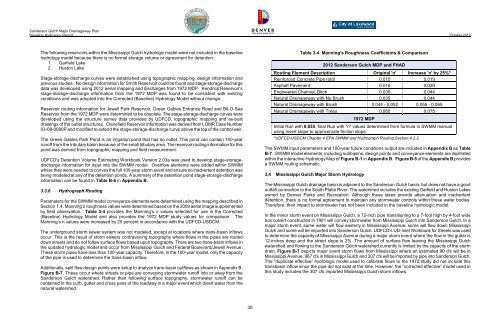
Table 3-4 Manning's Roughness Coefficients & Comparison<br />
<strong>2012</strong> Sanderson Gulch MDP and FHAD<br />
Routing Element Description Original 'n' Increase 'n' by 25%*<br />
Reinforced Concrete Pipe (old) 0.015 0.019<br />
Asphalt Pavement 0.016 0.020<br />
Engineered Channel, Ditch 0.035 0.044<br />
Natural <strong>Drainage</strong>way with No Brush 0.035 0.044<br />
Natural <strong>Drainage</strong>way with Brush 0.044 - 0.052 0.055 - 0.065<br />
Natural <strong>Drainage</strong>way with Trees 0.060 0.075<br />
1972 MDP<br />
Initial Run with 0.035, final Run with "n" values determined from formula in SWMM manual<br />
using invert slope to approximate friction slope.<br />
*UDFCD-USDCM Chapter 4 EPA SWMM and Hydrograph Routing Section 4.2.2.<br />
The SWMM input parameters and 100-year future conditions output are included in Appendix B as Table<br />
B-7. SWMM model elements, including subbasins, design points and conveyance elements are illustrated<br />
within the interactive <strong>Hydrology</strong> Map of Figure B-1 in Appendix B. Figure B-5 of the Appendix B provides<br />
a SWMM routing schematic.<br />
3.4 Mississippi Gulch Major Storm <strong>Hydrology</strong><br />
The Mississippi Gulch drainage basin is adjacent to the Sanderson Gulch basin, but does not have a good<br />
outfall connection to the South Platte River. The watershed includes the existing Garfield and Huston Lakes<br />
owned by Denver Parks and Recreation. Although these lakes provide attenuation and inadvertent<br />
detention, there is no formal agreement to maintain any stormwater controls within these water bodies.<br />
Therefore, their impact to stormwater has not been included in the baseline hydrologic model.<br />
In the minor storm event on Mississippi Gulch, a 72-inch pipe transitioning to a 7-foot high by 4-foot wide<br />
box culvert constructed in 1981 will convey stormwater from Mississippi Gulch into Sanderson Gulch. In a<br />
major storm event, some water will flow easterly in Mississippi Avenue, some will flow down Mississippi<br />
Gulch and some will be imported into Sanderson Gulch. UDFCD’s UD-Inlet Workbook for Streets was used<br />
to determine the capacity of Mississippi Avenue during a major storm event where the flow in the gutter is<br />
12-inches deep and the street slope is 2%. The amount of surface flow leaving the Mississippi Gulch<br />
watershed and flowing to the Sanderson Gulch watershed currently is limited by the capacity of the storm<br />
drain. Figure B-7 depicts major event storm flows from Mississippi where an estimated 90 cfs will be in<br />
Mississippi Avenue, 987 cfs in Mississippi Gulch and 307 cfs will be imported by pipe into Sanderson Gulch.<br />
The “duplicate effective” hydrologic model used to calibrate flows to the 1972 study did not include this<br />
transbasin inflow since the pipe did not exist at the time. However, the “corrected effective” model used in<br />
this study includes the 307 cfs imported Mississippi Gulch storm inflows.<br />
30


