

Final Baseline Hydrology Report - October 2012 - Urban Drainage ...
Final Baseline Hydrology Report - October 2012 - Urban Drainage ...
Final Baseline Hydrology Report - October 2012 - Urban Drainage ...

Create successful ePaper yourself
Turn your PDF publications into a flip-book with our unique Google optimized e-Paper software.
Sanderson Gulch Major <strong>Drainage</strong>way Plan<br />
<strong>Baseline</strong> <strong>Hydrology</strong> <strong>Report</strong> <strong>October</strong> <strong>2012</strong><br />
Maintenance. Maintenance of Kendrick Lake Park is the responsibility of the City of Lakewood and occurs<br />
on a regular schedule for the manicured turf areas and park amenities. Mowing practices typically occur<br />
once or twice during the growing season for the non-irrigated dryland grass areas. There are no UDFCD<br />
maintenance responsibilities through Reach 12.<br />
Parks and Recreation. Smith Reservoir includes a gravel loop trail around the reservoir, but there is no<br />
public access to the water. Kendrick Lake Park is 58 acres, including the reservoir surface area, and<br />
includes park and recreation facilities that include a paved parking lot, restrooms, demonstration gardens,<br />
picnic shelters and a playground. A continuous gravel loop trail around the reservoir provides pedestrian<br />
and fishing access.<br />
Water Quality. Smith Reservoir and Kendrick Reservoir provide passive water quality treatment.<br />
North Sanderson Gulch<br />
Reach NS1 – Sanderson Gulch Confluence to S. Pierce Street (Lakewood)<br />
Landscape and Ecology. This reach is dominated by heavy riparian vegetation species including<br />
cottonwood, willow and rushes. A large wetland pond area with some riparian species exists in the middle<br />
of the Greenbelt. Upland species of non-irrigated dryland grasses are predominantly wheatgrass and<br />
fescue. Invasive species (thistle, kochia, smartweed, bindweed, prickly lettuce, common mallow, barnyard<br />
grass, Johnsongrass, pigweed, rag weed, curly dock, halogeton, redstem filaree, alfalfa, Siberian elm,<br />
Chinese elm and Russian olive) are present, especially in the open non-irrigated upland areas.<br />
Maintenance. The White Fence Farm Filing No. 1 channel reach from the wetland pond to the confluence<br />
is eligible for UDFCD maintenance. The City of Lakewood maintains the reach between S. Harlan Circle<br />
and S. Pierce Street, with routine maintenance assistance from UDFCD.<br />
Parks and Recreation. The Sanderson Gulch Greenway is owned by the City of Lakewood and includes a<br />
continuous concrete pubic bike/pedestrian access with at-grade crossings.<br />
Water Quality. The Sanderson Gulch Greenway wetland pond provides passive water quality treatment.<br />
Reach NS2 – S. Pierce Street to Wadsworth Boulevard (Lakewood)<br />
Reach NS1 is approximately 2,800 feet long and extends upstream from the confluence with Sanderson<br />
Gulch to S. Pierce Street. The 2009 North Sanderson Gulch Greenbelt Improvements project stabilized the<br />
channel and included a large wetland pond area. The channel in this reach is contained in a narrow openspace<br />
corridor mostly less than 100-feet in width. It is recently stabilized with 11 relatively new grouted<br />
boulder drop structures but has an unlined invert and typically vegetated soil riprap banks. There is a very<br />
small, intermittent base flow in the lower portion of the reach and standing water in the small ponds and<br />
drop stilling basins. All of the existing drop structures and most channel banks are in good condition. A<br />
continuous concrete pedestrian path exists in the reach and the lower third has a path on both sides of the<br />
channel. The road crossing on S. Harlan Circle has 100-year capacity.<br />
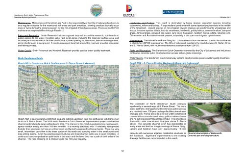
The character of North Sanderson Gulch changes<br />
significantly in several ways at S. Pierce Street. The more<br />
open, aesthetic, drainageway with continuous public access<br />
and relatively new, 100-year drainage facilities downstream<br />
changes at S. Pierce Street to a 30-foot width constructed<br />
channel with a concrete invert, steep gabion mattress banks<br />
and no public access through Reach NS2. The small base<br />
flows which exist downstream disappear above S. Pierce<br />
Street. The concrete channel invert has deteriorated in<br />
many areas and the four bridge crossings at Pierce, Quay,<br />
Upham and Calahan have only approximately 10-year<br />
capacity with numerous adjacent residential structures in<br />
the floodplain. Significant improvements to the existing<br />
drainage facilities are recommended in this reach.<br />
Channel downstream of Wadsworth.<br />
Concrete pan and drop structure.<br />
12


