

Final Baseline Hydrology Report - October 2012 - Urban Drainage ...
Final Baseline Hydrology Report - October 2012 - Urban Drainage ...
Final Baseline Hydrology Report - October 2012 - Urban Drainage ...

Create successful ePaper yourself
Turn your PDF publications into a flip-book with our unique Google optimized e-Paper software.
Sanderson Gulch Major <strong>Drainage</strong>way Plan<br />
<strong>Baseline</strong> <strong>Hydrology</strong> <strong>Report</strong> <strong>October</strong> <strong>2012</strong><br />
Landscape and Ecology. Channel banks in this reach are<br />
predominately grass species including wheatgrass and<br />
fescue. Invasive species include Russian olive, thistle,<br />
kochia, smartweed, bindweed, prickly lettuce, common<br />
mallow, barnyard grass, Johnsongrass, pigweed, rag weed,<br />
curly dock and alfalfa.<br />
Maintenance. Routine and emergency maintenance<br />
responsibilities are performed by the City of Lakewood and<br />
UDFCD to maintain channel capacity and provide repairs<br />
after a storm event.<br />
Landscape and Ecology. Grass species making up the<br />
channel banks are predominantly wheatgrass and fescue.<br />
The corridor is narrow and linear with few trees. Where<br />
trees do exist, Russian olive is the most prevalent species.<br />
Invasive species include thistle, kochia, smartweed,<br />
bindweed, prickly lettuce, common mallow, barnyard grass,<br />
Johnsongrass, pigweed, rag weed, curly dock and alfalfa.<br />
Maintenance. Routine maintenance responsibilities are<br />
generally performed by UDFCD to maintain flood capacity<br />
and provide repairs after a storm event.<br />
Parks and Recreation. There is no public access, public<br />
park or open space facilities within Reach NS2. Pedestrian<br />
and bicycle connections are achieved on the local<br />
residential street network in the neighborhood.<br />
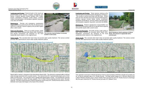
The concrete channel bottom is severely<br />
eroded in some areas.<br />
Parks and Recreation. No public access, public parks or<br />
open space facilities are provided within Reach NS3.<br />
Pedestrian connections are achieved on the local<br />
residential street network in the neighborhood.<br />
North Sanderson Gulch upstream of Alison<br />
Street. The channel is trapezoidal with a<br />
concrete pan.<br />
Water Quality. This concrete lined reach does not provide water quality treatment. The narrow corridor<br />
provides little opportunity for future water quality treatment options.<br />
Reach NS3 – S. Wadsworth Boulevard to S. Balsam Court (Lakewood)<br />
Water Quality. This concrete lined reach does not provide water quality treatment. The narrow corridor<br />
provides little opportunity for future water quality treatment options.<br />
Reach NS4 S. Balsam Court to S. Garrison Street (Lakewood)<br />
Reach NS3 is similar in character to the downstream Reach NS2. The channel is contained within a 36-foot<br />
wide drainage easement with no public access. The channel has 2H:1V grassed side slopes and a 4-foot<br />
width concrete invert. The concrete invert is significantly deteriorated in areas. The Wadsworth crossing<br />
has been upgraded to nearly 100-year capacity. The S. Allison Street crossing provides nearly 100-year<br />
capacity. The open channel portion of North Sanderson Gulch ends at W. Florida Avenue where a 36-inch<br />
diameter storm pipe discharges to the head of the channel.<br />
This upstream-most reach of North Sanderson Gulch is approximately 3,400 feet in length and consists of a<br />
24- to 36-inch diameter pipe in W. Florida Avenue. The pipe system begins at S. Garrison Street at the<br />
outfall of Robbins-Dasher Lake in Green Gables Park and extends down W. Florida Avenue to discharge<br />
into the open channel at W. Florida Avenue just east of S. Balsam Court.<br />
13


