2.1 Overview of the Proposed Project - Keystone XL pipeline - US ...
2.1 Overview of the Proposed Project - Keystone XL pipeline - US ...
2.1 Overview of the Proposed Project - Keystone XL pipeline - US ...

Create successful ePaper yourself
Turn your PDF publications into a flip-book with our unique Google optimized e-Paper software.
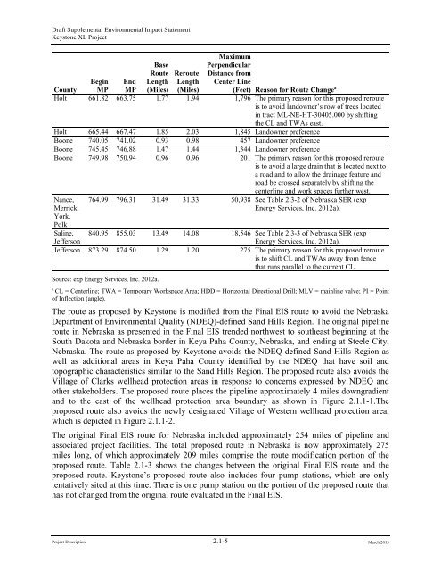
Draft Supplemental Environmental Impact Statement<strong>Keystone</strong> <strong>XL</strong> <strong>Project</strong>BaseRouteLength(Miles)RerouteLength(Miles)MaximumPerpendicularDistance fromCenter Line(Feet) Reason for Route Change aCountyBeginMPEndMPHolt 661.82 663.75 1.77 1.94 1,796 The primary reason for this proposed rerouteis to avoid landowner’s row <strong>of</strong> trees locatedin tract ML-NE-HT-30405.000 by shifting<strong>the</strong> CL and TWAs east.Holt 665.44 667.47 1.85 2.03 1,845 Landowner preferenceBoone 740.05 741.02 0.93 0.98 457 Landowner preferenceBoone 745.45 746.88 1.47 1.44 1,344 Landowner preferenceBoone 749.98 750.94 0.96 0.96 201 The primary reason for this proposed rerouteis to avoid a large drain that is located next toa road and to allow <strong>the</strong> drainage feature androad be crossed separately by shifting <strong>the</strong>centerline and work spaces fur<strong>the</strong>r west.Nance,Merrick,York,Polk764.99 796.31 31.49 31.33 50,938 See Table 2.3-2 <strong>of</strong> Nebraska SER (expEnergy Services, Inc. 2012a).Saline,Jefferson840.95 855.03 13.49 14.08 18,546 See Table 2.3-3 <strong>of</strong> Nebraska SER (expEnergy Services, Inc. 2012a).Jefferson 873.29 874.50 1.29 1.20 275 The primary reason for this proposed rerouteis to shift CL and TWAs away from fencethat runs parallel to <strong>the</strong> current CL.Source: exp Energy Services, Inc. 2012a.aCL = Centerline; TWA = Temporary Workspace Area; HDD = Horizontal Directional Drill; MLV = mainline valve; PI = Point<strong>of</strong> Inflection (angle).The route as proposed by <strong>Keystone</strong> is modified from <strong>the</strong> Final EIS route to avoid <strong>the</strong> NebraskaDepartment <strong>of</strong> Environmental Quality (NDEQ)-defined Sand Hills Region. The original <strong>pipeline</strong>route in Nebraska as presented in <strong>the</strong> Final EIS trended northwest to sou<strong>the</strong>ast beginning at <strong>the</strong>South Dakota and Nebraska border in Keya Paha County, Nebraska, and ending at Steele City,Nebraska. The route as proposed by <strong>Keystone</strong> avoids <strong>the</strong> NDEQ-defined Sand Hills Region aswell as additional areas in Keya Paha County identified by <strong>the</strong> NDEQ that have soil andtopographic characteristics similar to <strong>the</strong> Sand Hills Region. The proposed route also avoids <strong>the</strong>Village <strong>of</strong> Clarks wellhead protection areas in response to concerns expressed by NDEQ ando<strong>the</strong>r stakeholders. The proposed route places <strong>the</strong> <strong>pipeline</strong> approximately 4 miles downgradientand to <strong>the</strong> east <strong>of</strong> <strong>the</strong> wellhead protection area boundary as shown in Figure <strong>2.1</strong>.1-1.Theproposed route also avoids <strong>the</strong> newly designated Village <strong>of</strong> Western wellhead protection area,which is depicted in Figure <strong>2.1</strong>.1-2.The original Final EIS route for Nebraska included approximately 254 miles <strong>of</strong> <strong>pipeline</strong> andassociated project facilities. The total proposed route in Nebraska is now approximately 275miles long, <strong>of</strong> which approximately 209 miles comprise <strong>the</strong> route modification portion <strong>of</strong> <strong>the</strong>proposed route. Table <strong>2.1</strong>-3 shows <strong>the</strong> changes between <strong>the</strong> original Final EIS route and <strong>the</strong>proposed route. <strong>Keystone</strong>’s proposed route also includes four pump stations, which are onlytentatively sited at this time. There is one pump station on <strong>the</strong> portion <strong>of</strong> <strong>the</strong> proposed route thathas not changed from <strong>the</strong> original route evaluated in <strong>the</strong> Final EIS.<strong>Project</strong> Description <strong>2.1</strong>-5 March 2013