

to download report - Geological Survey of Ireland
to download report - Geological Survey of Ireland
to download report - Geological Survey of Ireland
- No tags were found...

Create successful ePaper yourself
Turn your PDF publications into a flip-book with our unique Google optimized e-Paper software.
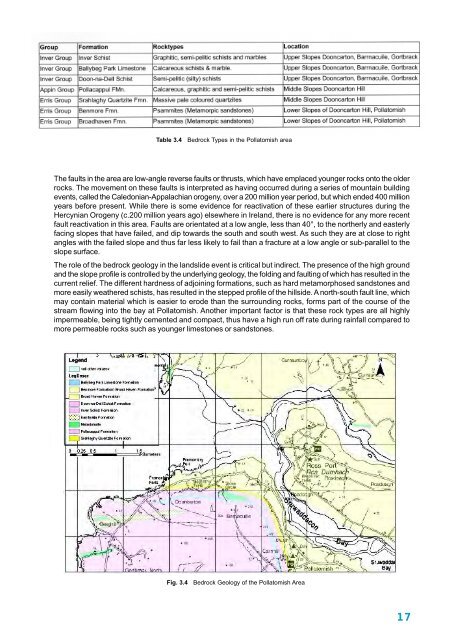
Table 3.4 Bedrock Types in the Polla<strong>to</strong>mish areaThe faults in the area are low-angle reverse faults or thrusts, which have emplaced younger rocks on<strong>to</strong> the olderrocks. The movement on these faults is interpreted as having occurred during a series <strong>of</strong> mountain buildingevents, called the Caledonian-Appalachian orogeny, over a 200 million year period, but which ended 400 millionyears before present. While there is some evidence for reactivation <strong>of</strong> these earlier structures during theHercynian Orogeny (c.200 million years ago) elsewhere in <strong>Ireland</strong>, there is no evidence for any more recentfault reactivation in this area. Faults are orientated at a low angle, less than 40°, <strong>to</strong> the northerly and easterlyfacing slopes that have failed, and dip <strong>to</strong>wards the south and south west. As such they are at close <strong>to</strong> rightangles with the failed slope and thus far less likely <strong>to</strong> fail than a fracture at a low angle or sub-parallel <strong>to</strong> theslope surface.The role <strong>of</strong> the bedrock geology in the landslide event is critical but indirect. The presence <strong>of</strong> the high groundand the slope pr<strong>of</strong>ile is controlled by the underlying geology, the folding and faulting <strong>of</strong> which has resulted in thecurrent relief. The different hardness <strong>of</strong> adjoining formations, such as hard metamorphosed sands<strong>to</strong>nes andmore easily weathered schists, has resulted in the stepped pr<strong>of</strong>ile <strong>of</strong> the hillside. A north-south fault line, whichmay contain material which is easier <strong>to</strong> erode than the surrounding rocks, forms part <strong>of</strong> the course <strong>of</strong> thestream flowing in<strong>to</strong> the bay at Polla<strong>to</strong>mish. Another important fac<strong>to</strong>r is that these rock types are all highlyimpermeable, being tightly cemented and compact, thus have a high run <strong>of</strong>f rate during rainfall compared <strong>to</strong>more permeable rocks such as younger limes<strong>to</strong>nes or sands<strong>to</strong>nes.Fig. 3.4 Bedrock Geology <strong>of</strong> the Polla<strong>to</strong>mish Area17


