

to download report - Geological Survey of Ireland
to download report - Geological Survey of Ireland
to download report - Geological Survey of Ireland
- No tags were found...

You also want an ePaper? Increase the reach of your titles
YUMPU automatically turns print PDFs into web optimized ePapers that Google loves.
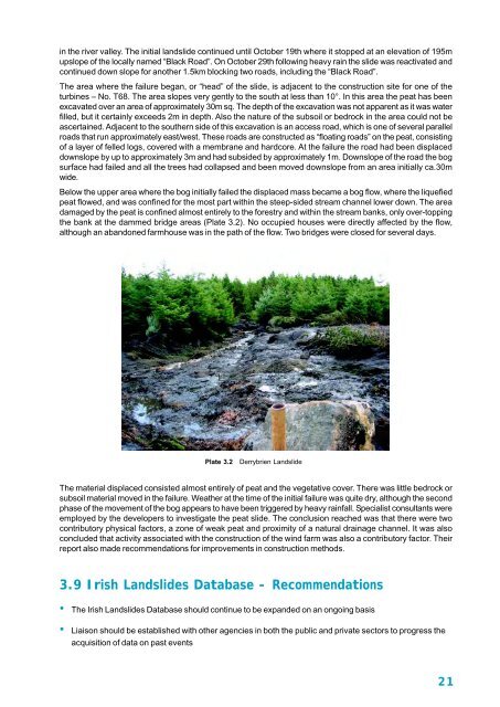
in the river valley. The initial landslide continued until Oc<strong>to</strong>ber 19th where it s<strong>to</strong>pped at an elevation <strong>of</strong> 195mupslope <strong>of</strong> the locally named “Black Road”. On Oc<strong>to</strong>ber 29th following heavy rain the slide was reactivated andcontinued down slope for another 1.5km blocking two roads, including the “Black Road”.The area where the failure began, or “head” <strong>of</strong> the slide, is adjacent <strong>to</strong> the construction site for one <strong>of</strong> theturbines – No. T68. The area slopes very gently <strong>to</strong> the south at less than 10°. In this area the peat has beenexcavated over an area <strong>of</strong> approximately 30m sq. The depth <strong>of</strong> the excavation was not apparent as it was waterfilled, but it certainly exceeds 2m in depth. Also the nature <strong>of</strong> the subsoil or bedrock in the area could not beascertained. Adjacent <strong>to</strong> the southern side <strong>of</strong> this excavation is an access road, which is one <strong>of</strong> several parallelroads that run approximately east/west. These roads are constructed as “floating roads” on the peat, consisting<strong>of</strong> a layer <strong>of</strong> felled logs, covered with a membrane and hardcore. At the failure the road had been displaceddownslope by up <strong>to</strong> approximately 3m and had subsided by approximately 1m. Downslope <strong>of</strong> the road the bogsurface had failed and all the trees had collapsed and been moved downslope from an area initially ca.30mwide.Below the upper area where the bog initially failed the displaced mass became a bog flow, where the liquefiedpeat flowed, and was confined for the most part within the steep-sided stream channel lower down. The areadamaged by the peat is confined almost entirely <strong>to</strong> the forestry and within the stream banks, only over-<strong>to</strong>ppingthe bank at the dammed bridge areas (Plate 3.2). No occupied houses were directly affected by the flow,although an abandoned farmhouse was in the path <strong>of</strong> the flow. Two bridges were closed for several days.Plate 3.2 Derrybrien LandslideThe material displaced consisted almost entirely <strong>of</strong> peat and the vegetative cover. There was little bedrock orsubsoil material moved in the failure. Weather at the time <strong>of</strong> the initial failure was quite dry, although the secondphase <strong>of</strong> the movement <strong>of</strong> the bog appears <strong>to</strong> have been triggered by heavy rainfall. Specialist consultants wereemployed by the developers <strong>to</strong> investigate the peat slide. The conclusion reached was that there were twocontribu<strong>to</strong>ry physical fac<strong>to</strong>rs, a zone <strong>of</strong> weak peat and proximity <strong>of</strong> a natural drainage channel. It was alsoconcluded that activity associated with the construction <strong>of</strong> the wind farm was also a contribu<strong>to</strong>ry fac<strong>to</strong>r. Their<strong>report</strong> also made recommendations for improvements in construction methods.3.9 Irish Landslides Database - Recommendations• The Irish Landslides Database should continue <strong>to</strong> be expanded on an ongoing basis• Liaison should be established with other agencies in both the public and private sec<strong>to</strong>rs <strong>to</strong> progress theacquisition <strong>of</strong> data on past events21


