to download report - Geological Survey of Ireland
to download report - Geological Survey of Ireland
to download report - Geological Survey of Ireland
- No tags were found...
You also want an ePaper? Increase the reach of your titles
YUMPU automatically turns print PDFs into web optimized ePapers that Google loves.
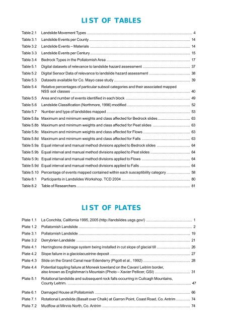
LIST OF TABLESTable 2.1 Landslide Movement Types .................................................................................................. 4Table 3.1 Landslide Events per County .............................................................................................. 14Table 3.2 Landslide Events – Materials ............................................................................................. 14Table 3.3 Landslide Events per Century ............................................................................................. 15Table 3.4 Bedrock Types in the Polla<strong>to</strong>mish Area .............................................................................. 17Table 5.1 Digital datasets <strong>of</strong> relevance <strong>to</strong> landslide hazard assessment ............................................ 37Table 5.2 Digital Sensor Data <strong>of</strong> relevance <strong>to</strong> landslide hazard assessment ...................................... 38Table 5.3 Datasets available for Co. Mayo case study ....................................................................... 39Table 5.4 Relative percentages <strong>of</strong> particular subsoil categories and their associated mappedNSS soil classes ............................................................................................................... 40Table 5.5 Area and number <strong>of</strong> events identified in each block ............................................................ 49Table 5.6 Landslide Classification (Northmore, 1996) modified ........................................................... 52Table 5.7 Number and type <strong>of</strong> landslides mapped .............................................................................. 53Table 5.8a Maximum and minimum weights and class affected for Bedrock slides .............................. 63Table 5.8b Maximum and minimum weights and class affected for Peat slides ................................... 63Table 5.8c Maximum and minimum weights and class affected for Flows ............................................ 63Table 5.8d Maximum and minimum weights and class affected for Falls ............................................. 63Table 5.9a Equal interval and manual method divisions applied <strong>to</strong> Bedrock slides ............................... 64Table 5.9b Equal interval and manual method divisions applied <strong>to</strong> Peat slides ..................................... 64Table 5.9c Equal interval and manual method divisions applied <strong>to</strong> Flows ............................................. 64Table 5.9d Equal interval and manual method divisions applied <strong>to</strong> Falls ............................................... 64Table 5.10 Percentage <strong>of</strong> events mapped contained within each susceptibility category ...................... 58Table 8.1 Participants in Landslides Workshop. TCD 2004 ................................................................ 80Table 8.2 Table <strong>of</strong> Researchers.......................................................................................................... 81LIST OF PLATESPlate 1.1 La Conchita, California 1995, 2005 (http://landslides.usgs.gov/) ........................................... 1Plate 1.2 Polla<strong>to</strong>mish Landslide .......................................................................................................... 2Plate 3.1 Polla<strong>to</strong>mish Landslide ........................................................................................................ 19Plate 3.2 Derrybrien Landslide .......................................................................................................... 21Plate 4.1 Herringbone drainage system being installed in cut slope <strong>of</strong> glacial till ............................... 26Plate 4.2 Slope failure in a glaciolacustrine deposit ........................................................................... 27Plate 4.3 Slide on the Grand Canal near Edenderry (Pigott et al., 1992) ............................................ 28Plate 4.4 Potential <strong>to</strong>ppling failure at Monesk <strong>to</strong>wnland on the Cavan/ Leitrim border,also known as Englishman’s Mountain (Pho<strong>to</strong> – Xavier Pellicer, GSI) ................................. 31Plate 5.1 Rotational landslide and subsequent rock falls occurring in Cuilcagh Mountains,County Leitrim. ................................................................................................................... 47Plate 6.1 Damaged House at Polla<strong>to</strong>mish ......................................................................................... 66Plate 7.1 Rotational Landslide (Basalt over Chalk) at Garron Point, Coast Road, Co. Antrim ............. 74Plate 7.2 Mudflow at Minnis North, Co. Antrim .................................................................................. 74


