

to download report - Geological Survey of Ireland
to download report - Geological Survey of Ireland
to download report - Geological Survey of Ireland
- No tags were found...

You also want an ePaper? Increase the reach of your titles
YUMPU automatically turns print PDFs into web optimized ePapers that Google loves.
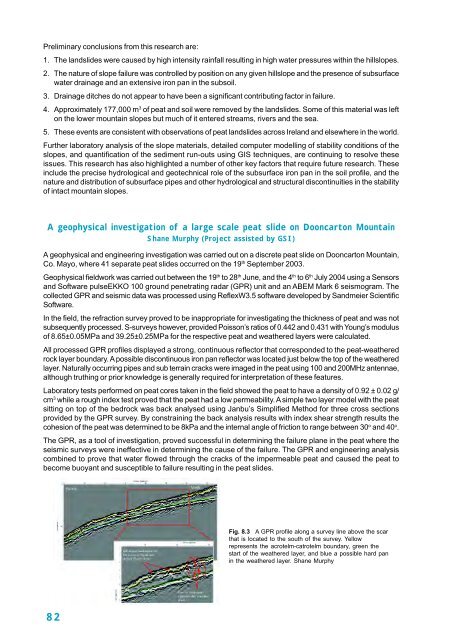
Preliminary conclusions from this research are:1. The landslides were caused by high intensity rainfall resulting in high water pressures within the hillslopes.2. The nature <strong>of</strong> slope failure was controlled by position on any given hillslope and the presence <strong>of</strong> subsurfacewater drainage and an extensive iron pan in the subsoil.3. Drainage ditches do not appear <strong>to</strong> have been a significant contributing fac<strong>to</strong>r in failure.4. Approximately 177,000 m 3 <strong>of</strong> peat and soil were removed by the landslides. Some <strong>of</strong> this material was lef<strong>to</strong>n the lower mountain slopes but much <strong>of</strong> it entered streams, rivers and the sea.5. These events are consistent with observations <strong>of</strong> peat landslides across <strong>Ireland</strong> and elsewhere in the world.Further labora<strong>to</strong>ry analysis <strong>of</strong> the slope materials, detailed computer modelling <strong>of</strong> stability conditions <strong>of</strong> theslopes, and quantification <strong>of</strong> the sediment run-outs using GIS techniques, are continuing <strong>to</strong> resolve theseissues. This research has also highlighted a number <strong>of</strong> other key fac<strong>to</strong>rs that require future research. Theseinclude the precise hydrological and geotechnical role <strong>of</strong> the subsurface iron pan in the soil pr<strong>of</strong>ile, and thenature and distribution <strong>of</strong> subsurface pipes and other hydrological and structural discontinuities in the stability<strong>of</strong> intact mountain slopes.A geophysical investigation <strong>of</strong> a large scale peat slide on Dooncar<strong>to</strong>n MountainShane Murphy (Project assisted by GSI)A geophysical and engineering investigation was carried out on a discrete peat slide on Dooncar<strong>to</strong>n Mountain,Co. Mayo, where 41 separate peat slides occurred on the 19 th September 2003.Geophysical fieldwork was carried out between the 19 th <strong>to</strong> 28 th June, and the 4 th <strong>to</strong> 6 th July 2004 using a Sensorsand S<strong>of</strong>tware pulseEKKO 100 ground penetrating radar (GPR) unit and an ABEM Mark 6 seismogram. Thecollected GPR and seismic data was processed using ReflexW3.5 s<strong>of</strong>tware developed by Sandmeier ScientificS<strong>of</strong>tware.In the field, the refraction survey proved <strong>to</strong> be inappropriate for investigating the thickness <strong>of</strong> peat and was notsubsequently processed. S-surveys however, provided Poisson’s ratios <strong>of</strong> 0.442 and 0.431 with Young’s modulus<strong>of</strong> 8.65±0.05MPa and 39.25±0.25MPa for the respective peat and weathered layers were calculated.All processed GPR pr<strong>of</strong>iles displayed a strong, continuous reflec<strong>to</strong>r that corresponded <strong>to</strong> the peat-weatheredrock layer boundary. A possible discontinuous iron pan reflec<strong>to</strong>r was located just below the <strong>to</strong>p <strong>of</strong> the weatheredlayer. Naturally occurring pipes and sub terrain cracks were imaged in the peat using 100 and 200MHz antennae,although truthing or prior knowledge is generally required for interpretation <strong>of</strong> these features.Labora<strong>to</strong>ry tests performed on peat cores taken in the field showed the peat <strong>to</strong> have a density <strong>of</strong> 0.92 ± 0.02 g/cm 3 while a rough index test proved that the peat had a low permeability. A simple two layer model with the peatsitting on <strong>to</strong>p <strong>of</strong> the bedrock was back analysed using Janbu’s Simplified Method for three cross sectionsprovided by the GPR survey. By constraining the back analysis results with index shear strength results thecohesion <strong>of</strong> the peat was determined <strong>to</strong> be 8kPa and the internal angle <strong>of</strong> friction <strong>to</strong> range between 30 o and 40 o .The GPR, as a <strong>to</strong>ol <strong>of</strong> investigation, proved successful in determining the failure plane in the peat where theseismic surveys were ineffective in determining the cause <strong>of</strong> the failure. The GPR and engineering analysiscombined <strong>to</strong> prove that water flowed through the cracks <strong>of</strong> the impermeable peat and caused the peat <strong>to</strong>become buoyant and susceptible <strong>to</strong> failure resulting in the peat slides.Fig. 8.3 A GPR pr<strong>of</strong>ile along a survey line above the scarthat is located <strong>to</strong> the south <strong>of</strong> the survey. Yellowrepresents the acrotelm-catrotelm boundary, green thestart <strong>of</strong> the weathered layer, and blue a possible hard panin the weathered layer. Shane Murphy82


