4.15 MB - Food Security Clusters
4.15 MB - Food Security Clusters
4.15 MB - Food Security Clusters
- No tags were found...

Create successful ePaper yourself
Turn your PDF publications into a flip-book with our unique Google optimized e-Paper software.
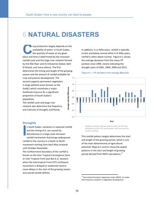
South Sudan: How a new country can feed its peopleNatural disasters6 NATURAL DISASTERSCrop production largely depends on theavailability of water. In South Sudan,the quantity of water at any givenplace and time is determined by the monsoonrainfall cycle and the large river network formedby the Nile River and its tributaries (Sobat, BahrEl Ghazal, and many others). The firstdetermines the timing and length of the growingseason and the amount of rainfall available forcrop and pasture development. Thesecond supports permanent vegetationin large wetland areas (known as theSudd),) which constitutes a majorlivelihood resource for a significantproportion of South Sudan’spopulation.The rainfall cycle and large rivernetwork also determine the frequencyand intensity of droughts and floods.In addition, in La Niña years, rainfall is typicallyerratic and below normal while in El Niño years,rainfall is often above normal. Figure 6.1 showsthe average deviation from the mean ITFposition since 1990, clearly indicating thedrought years of 2001, 2004, 2009 and 2011.Figure 6.1 – ITF deviation from average (May-Oct)DroughtsIn South Sudan, variations in seasonal rainfalland the timing of it, are caused bydisturbances in a large scale monsoonrainfall mechanism that brings widespreadrainfall to the country in a South to Northmovement starting from April-May onwardsuntil October-November.The northernmost boundary of the rainfall isknown as the Inter Tropical Convergence Zoneor Inter Tropical Front (see Box 6.1). Seasonswhen the Intertropical Front (ITF) northwardmovement is delayed or weakened tend tocause delays in the start of the growing seasonand overall rainfall deficits.Negative numbers indicate seasons when the ITF waspersistently south of its usual position and vice-versa forpositive numbersThis rainfall pattern largely determines the startand length of the growing period, which is oneof the main determinants of agriculturalpotential. Maps 6.1 and 6.2 show the spatialpatterns in the start and length of growingperiod derived from NDVI calculations. 1111 Normalized Deviation Vegetation Index (NDVI). An indexthat measures variation in vegetation development.36