4.15 MB - Food Security Clusters
4.15 MB - Food Security Clusters
4.15 MB - Food Security Clusters
- No tags were found...

You also want an ePaper? Increase the reach of your titles
YUMPU automatically turns print PDFs into web optimized ePapers that Google loves.
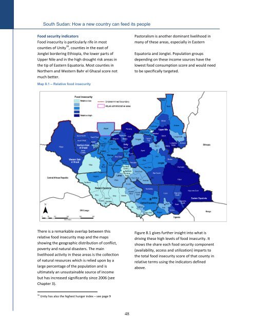
South Sudan: How a new country can feed its people<strong>Food</strong> security indicators<strong>Food</strong> insecurity is particularly rife in mostcounties of Unity 16 , counties in the east ofJonglei bordering Ethiopia, the lower parts ofUpper Nile and in the high drought risk areas inthe tip of Eastern Equatoria. Most counties inNorthern and Western Bahr el Ghazal score notmuch better.Pastoralism is another dominant livelihood inmany of these areas, especially in EasternEquatoria and Jonglei. Population groupsdepending on these income sources have thelowest food consumption score and would needto be specifically targeted.Map 8.1 – Relative food insecurityThere is a remarkable overlap between thisrelative food insecurity map and the mapsshowing the geographic distribution of conflict,poverty and natural disasters. The mainlivelihood activity in these areas is the collectionof natural resources which is relied upon by alarge percentage of the population and isultimately an unsustainable source of incomebut has increased significantly since 2006 (seeChapter 3).Figure 8.1 gives further insight into what isdriving these high levels of food insecurity. Itshows the share each food security component(availability, access and utilization) imparts tothe total food insecurity score of that county inrelative terms using the indicators definedabove.16 Unity has also the highest hunger index – see page 948