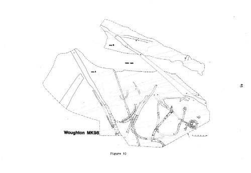
small area beyond the water main was also investigated (Area B), (Fig. 10).In addition, a large area was stripped by machine on the S embankment of theroundabout following the provisional results of a magnetometer survey undertakenby the Ancient Monuments Laboratory of the DoE (Area C).Several new features were found in Areas A and B, and this, togetherwith re-interpretation of those already discovered, has necessitated renumberingof some of the features described in the earlier report. Laterdisturbance of the site resulted from ridge-and-furrow ploughing, a hedgerowgully, and the insertion of land drains. Nearly all of the features foundwere of Late Iron Age (Belgic) date, probably Clst AD. Only feature 25, ashallow gully, failed to provide any dating evidence whatsoever.Feature 1, 2.5m. wide and lm. deep was exposed <strong>for</strong> a length of 13m. fromits butt. It ran in a SW direction and may have been part of the same enclosureditch (also of Belgic date), a length of which was exposed and plannedduring construction of the roundabout.Features 2 and 3 (gully and ditch found in the 1974-75 excavations) werefound to continue, Feature 2 <strong>for</strong> a total length of 16.0m., when it merged with3, and Feature 3 <strong>for</strong> a total excavated length of 37.0m. Feature 2 probablycontained a palisade fence around the house site represented by circulargullies 5 and 6. Ditch 3 post-dated these features and may have <strong>for</strong>med, withDitch 24, another smaller enclosure.Features 4 and 8 and 26 were only visible in a fragmented state owing tolater disturbance. Gullies 7 and 9 were probably dug <strong>for</strong> drainage, 9possibly being contemporary with circular gullies 5 and 6, while 7 post-datedthese features and gully 10. This feature, which may have contained apalisade fence probably <strong>for</strong>med part of an enclosure system with similargullies 11 and 12. Gullies 15, 16 and 17, probably <strong>for</strong> drainage, seem to havepre-dated these features.Slightly later than these enclosures was one <strong>for</strong>med by a more substantialfeature Ditch 13, which contained concentrations of stone packing, presumably<strong>for</strong> quite large posts. This butted at its N end and may have continued asFeature 14. Within this enclosure was a small, shallow pit (19) and acomplex of features 18, 20, 21, 22 and 23.Feature 18, a long, narrow post pit, may have been associated with thebanana-shaped gully 21, roughly at right angles toit, together <strong>for</strong>ming partof a small structure.Feature 20 was a continuous, roughly circular gully, with a diameter of2.5m. It was later than 21 and may have had a small stone causeway at the E.Within it were two shallow, irregularly shaped pits - 22 and 23. The functionof this small circular structure was not clear; hardly large enough <strong>for</strong> adwelling, it may have been used as a store or workshop.The magnetometer survey of Area C showed several linear features and twovery large anomalies which appeared to be pits. Work is still in progress(December 1977) on the stripped area, which corresponds to a substantial partof the area surveyed, but excavation has already confirmed several of thefeatures shown by the survey, as well as revealing the presence of many more,too small to have registered as anomalies.Features investigated so far include enclosure ditches, a large pit, andseveral gullies, all containing Roman material, and smaller, less distinctfeatures containing Belgic material similar to that from Areas A and B.Work will continue on Area C during the winter, after which the resultsof these excavations and those of 1974-75 will be combined with those of the
1water main\Ns\\)Woughton MK98I\-"aFigure 10
- Page 3: fce&A.J.COUNCIL FOR BRITISH ARCHAEO
- Page 6 and 7: 2PREHISTORICMARSWORTH,Buckinghamshi
- Page 8 and 9: L'The number of flints illustrated
- Page 10 and 11: .DORt$1FiTER.:577S(144.50Otel Stree
- Page 12 and 13: 8Key for Figure 4No. 1 Beaker with
- Page 14 and 15: 10EXCAVATIONS AT MIDDLETON STONEY,
- Page 16 and 17: 12ANGLO-SAXONNORTHAMPTONSHIRE CEMET
- Page 18 and 19: 14RAUNDS, Northamptonshire (SP 9987
- Page 20 and 21: GROVE PRIORYf,,,,,,,,,,,,,Figure 6
- Page 22 and 23: 18The decay of this church was inev
- Page 24 and 25: 20in an otherwise unflinty very dar
- Page 26 and 27: 22s Neolithic flints and parts of p
- Page 28 and 29: 214in a single village. It also gav
- Page 30 and 31: AERIAL SURVEYS - Jim PickeringA num
- Page 32 and 33: 28traction site at Newnham near Bed
- Page 34 and 35: .INFORMATIONINHERITEDSURVIVALSsites
- Page 36 and 37: 32HISTORIC ENVIRONMENTPARISH SURVEY
- Page 38 and 39: 34of owner and condition of site; f
- Page 40 and 41: 5. Excavation, Post-Excavation and
- Page 42 and 43: 38sites and five sites at which Rom
- Page 44 and 45: 40NORTHAMPTON CASTLE (Site Code M13
- Page 46 and 47: 142MILTON KEYNES,DEVELOPMENT CORPOR
- Page 50 and 51: salvage operations which took place
- Page 52 and 53: THE ROMAN FEATURESIn its earliest p
- Page 54 and 55: DIAGRAM SHOWING THE LIMITATIONS OF
- Page 56 and 57: 52did seem to be specifically conce
- Page 58 and 59: , i"1111!'.LTrsG j4.-+...1';r1* pp.
- Page 60 and 61: 56Building 32This was a small lean-
- Page 62 and 63: 58POST EXCAVATIONRomanThe Bradwell
- Page 64 and 65: 60twenty early maps of villages wit
- Page 66 and 67: 62OXFORDSHIRE COUATY COUNCIL DEPART
- Page 68 and 69: 6)4//TitEARTHWORKSWORKED FLINTS1,,b
- Page 71 and 72: 67route across the Chil Brook strea
- Page 73 and 74: 69\ 1 1/it\\\L/Figure 20bside and i
- Page 75 and 76: 7116, Ock Street similarly began as
- Page 77 and 78: 73MINSTER LOVELL , Oxon.DOVECOTE AT
- Page 81 and 82: 77known within the parish at presen
- Page 83 and 84: 79number of smaller closes by 1620.
- Page 85 and 86: 810 Metres 100L:C1111:177STANTONHOU
- Page 87 and 88: 83The two surviving pubs in the vil
- Page 89 and 90: 85Stone-quarry (PRN 1021) and limek
- Page 91 and 92: 87Richard, R.L. (ed)The progress no
- Page 93 and 94: 894. Central village nucleusEarthwo
- Page 95 and 96: 91BUILDINGSThe oldest surviving bui
- Page 97 and 98: 93interior has suffered badly from
- Page 99 and 100:
95OXFORDSHIRE ARCHAEOLOGICAL UNIT 1
- Page 101 and 102:
97the Unit's publication programme
- Page 103 and 104:
99the University continue to grow n
- Page 105 and 106:
101NEW ARCHAEOLOGICAL SITES ON THE
- Page 107 and 108:
103Shrivenham (SU 263877) ? Field S
- Page 109 and 110:
105FINSTOCK, Topples - Richard Cham
- Page 111 and 112:
Figure 31ABINGDON/RADLEY, BARTON CO
- Page 113 and 114:
1094s...ISiII.II11..0.0 ..... .....
- Page 115 and 116:
,et/11,11MMMU/ f Pitt WU? eimtI:,.,
- Page 117 and 118:
113HARDWICK with YELFORDAMMISMVA00M
- Page 119 and 120:
water features filled insince 1810o
- Page 121 and 122:
117St. Helen's Church and the adjac
- Page 123 and 124:
1surface119OXFORD, St. Mary's Colle
- Page 125 and 126:
121of some arable land (V.C.H. Oxon
- Page 127 and 128:
123Opportunities for archaeologists
- Page 129 and 130:
125Luton MuseumThe Curator, Wardown
- Page 131 and 132:
127Oxford University Institute of A