GP1670F_1870F Operator's Manual - Furuno USA
GP1670F_1870F Operator's Manual - Furuno USA
GP1670F_1870F Operator's Manual - Furuno USA

You also want an ePaper? Increase the reach of your titles
YUMPU automatically turns print PDFs into web optimized ePapers that Google loves.
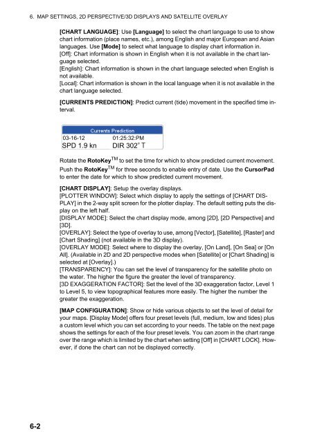
6. MAP SETTINGS, 2D PERSPECTIVE/3D DISPLAYS AND SATELLITE OVERLAY[CHART LANGUAGE]: Use [Language] to select the chart language to use to showchart information (place names, etc.), among English and major European and Asianlanguages. Use [Mode] to select what language to display chart information in.[Off]: Chart information is shown in English when it is not available in the chart languageselected.[English]: Chart information is shown in the chart language selected when English isnot available.[Local]: Chart information is shown in the local language when it is not available in thechart language selected.[CURRENTS PREDICTION]: Predict current (tide) movement in the specified time interval.03-16-12 01:25:32:PMSPD 1.9 knDIR 302Rotate the RotoKey TM to set the time for which to show predicted current movement.Push the RotoKey TM for three seconds to enable entry of date. Use the CursorPadto enter the date for which to show predicted current movement.[CHART DISPLAY]: Setup the overlay displays.[PLOTTER WINDOW]: Select which display to apply the settings of [CHART DIS-PLAY] in the 2-way split screen for the plotter display. The default setting puts the displayon the left half.[DISPLAY MODE]: Select the chart display mode, among [2D], [2D Perspective] and[3D].[OVERLAY]: Select the type of overlay to use, among [Vector], [Satellite], [Raster] and[Chart Shading] (not available in the 3D display).[OVERLAY MODE]: Select where to display the overlay, [On Land], [On Sea] or [OnAll]. (Available in 2D and 2D perspective modes when [Satellite] or [Chart Shading] isselected at [Overlay].)[TRANSPARENCY]: You can set the level of transparency for the satellite photo onthe water. The higher the figure the greater the level of transparency.[3D EXAGGERATION FACTOR]: Set the level of the 3D exaggeration factor, Level 1to Level 5, to view topographical features more easily. The higher the number thegreater the exaggeration.[MAP CONFIGURATION]: Show or hide various objects to set the level of detail foryour maps. [Display Mode] offers four preset levels (full, medium, low and tides) plusa custom level which you can set according to your needs. The table on the next pageshows the settings for each of the four preset levels. You can zoom in the chart rangeover the range which is limited by the chart when setting [Off] in [CHART LOCK]. However,if done the chart can not be displayed correctly.6-2