

1 Background - mountain.PROJECTS
1 Background - mountain.PROJECTS
1 Background - mountain.PROJECTS

Create successful ePaper yourself
Turn your PDF publications into a flip-book with our unique Google optimized e-Paper software.
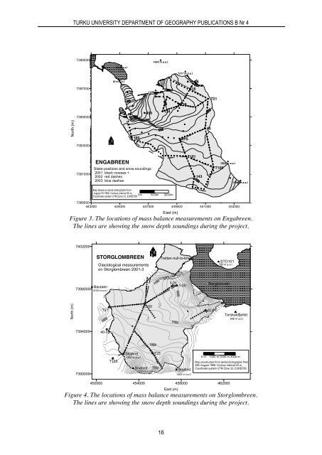
TURKU UNIVERSITY DEPARTMENT OF GEOGRAPHY PUBLICATIONS B Nr 4739900023 m a.s.l1454 m a.s.l.1217 m a.s.l.10 m a.s.l.16-987397000171109 m a.s.l.1638T217395000800134North (m)190EP54073930007391000ENGABREENStake positions and snow soundings2001 black crosses +2002 red dashes2003 blue dashesT1011431354 m a.s.l.T1051594 m a.s.l.Map based on aerial photographs fromAugust 25 1968. Contour interval 50 m.0mCoordinate system UTM Zone 33, EUREF891000m 2000m7389000443000 445000 447000 449000 451000 453000East (m)Figure 3. The locations of mass balance measurements on Engabreen.The lines are showing the snow depth soundings during the project.7402000STORGLOMBREENGlaciological measurementson Storglombreen 2001-3Tretten-null-to-breenSTO101760 m a.s.l.7398000Bautaen1218 m a.s.l.1-011-00StorglomvatnNorth (m)T213-0020-01Terskaldfjellet936 m a.s.l.739400040-00Snow depth soundings:2001 blue dashes2002 red crosses2003 black dashes7390000T105Skjæret T231352 m a.s.l.Snøtind1595 m a.s.l.Breitind1354 m a.s.l.0 m 1000 m 2000 m 3000 mMap constructed from aerial photographs from25th August 1968. Contour interval 25 m.Coordinate system UTM Zone 33, EUREF89.450000 454000 458000 462000East (m)Figure 4. The locations of mass balance measurements on Storglombreen.The lines are showing the snow depth soundings during the project.16


