TURKU UNIVERSITY DEPARTMENT OF GEOGRAPHY PUBLICATIONS B Nr 4The main social objective is to attract general public attention to economic, environmentaland demographic problems in areas adjacent to European glaciers, and to promote theefficient solution to those problems on the basis of regular and safe engineering activities andhydropower supply in the region, and the improvement of living conditions for the localpopulace.2.5 InnovationsNeither the origin nor the character of glacier changes in the Europe is completely known orfully understood at present. Research is focused on direct studies of both qualitative indicatorsand accurate quantitative measures of glacier changes at local and regional scale based onmodern developments in glacier remote sensing. OMEGA is focused on the use of hybridremote sensing techniques for the enhanced reconstruction of the surfaces of Hintereisfernerand Engabreen glaciers and a reliable estimate of their dynamics. In future, more glaciers willbe included in the system.Major innovative features of the project are 1) a new general concept of satellite operationalmonitoring in European glacial areas, 2) the use of modern developments in remote sensing,3) basic principles, original algorithms and program tools, 4) the detailed revision of availableglaciological data at regional level and the compilation of a glacier database and 5) regionalpatterns of glacier advance or retreat.The new general concept includes formulation of main tasks, determination of the subject, thecomplement of glacial objects under observation, methodology, the logical sequence andcontents of the principal stages as well as specific parameters of monitoring, such as therequired accuracy, detail and necessary interval between surveys. The use of moderndevelopment are repeat-pass and single-pass radar interferometry, differential interferometry,radio-echo sounding, laser scanning, GPS positioning, GIS technologies and digital imageprocessing for glacier mapping and revising glaciological detail. The basic principles, originalalgorithms and program tools are prepared for the interpretation of glacial and subglacialtopography, detection of main structural features of the glacier surface, classification ofglacier zones and semi-automatic change detection in spaceborne multitemporal optical andradar images. Regional tendency of glacier retreat or advance will be verified and the presentstate and potential glacier changes will be estimated at local scale.3 Study areasThe main requirements for the study areas were that old terrestrial and/or aerial photographyis available, and a long series of glaciological and meteorological records exist. Otherimportant factors are the availability of ground survey records, accessibility of the glaciersand the possibility to construct a ground control network. Finally the study areas relevance forglobal change studies must be evaluated.3.1 Engabreen and the Svartisen ice capsThe Svartisen ice caps (13º59' E; 66º40' N, 221 km 2 and 148 km 2 ) are located on the ArcticCircle in a maritime climate close to the Atlantic Ocean in Northern Norway. The altitudinalrange is from seven to 1600 m a.s.l. Annual precipitation is more than 2000 mm along the10
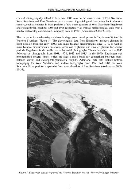
PETRI PELLIKKA AND KARI KAJUUTTI (ED)coast declining rapidly inland to less than 1000 mm on the eastern side of East Svartisen.West Svartisen and East Svartisen have a range of glaciological data going back almost acentury, such as changes in front position of two outlet glaciers of West Svartisen (Engabreenand Fondalsbreen) back to 1903 and 1906 respectively as well as meteorological data from anearby meteorological station (Glomfjord) back to 1920. (Andreassen 2000: 29-33).The study site for methodology and monitoring system development is Engabreen (38 km 2 ) inWestern Svartisen (Figure 1). The glaciological data from Engabreen includes changes infront position from the early 1900s and mass balance measurements since 1970, as well asmass balance measurements on several other outlet glaciers and smaller glaciers for shorterperiods. Engabreen is also well covered by aerial photographs. The earliest date back to 1945followed by photographs from 1968, 1978, 1983 and 1985. In the 1990s Engabreen wasphotographed several times, which provides a good basis for comparison between massbalancestudies and stereophotogrammetric outputs. Additional data sets include bottomtopography for West Svartisen and surface topography from 1968 and 1985 for WestSvartisen. Front position maps exist from several outlets of East Svartisen. (Andreassen 2000:29-33).Figure 1. Engabreen glacier is part of the Western Svartisen ice cap (Photo: Fjellanger Wideroe).11