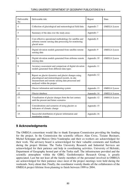
TURKU UNIVERSITY DEPARTMENT OF GEOGRAPHY PUBLICATIONS B Nr 4DeliverableNoDeliverable title Report Data4 Collection of glaciological and meteorological field data Appendix 7 OMEGA System5 Summary of the data over the study areas Appendix 76 Cost-effective operational methodology for satellite andairborne remote sensing data processing for monitoringglacial areas7 Digital elevation models generated from satellite remotesensing data8 Digital elevation models generated from airborne remotesensing data9 Accuracy assessment and comparison of digital elevationmodels generated from different data typesAppendix 8Appendix 9Appendix 10Appendix 11OMEGA SystemOMEGA System10Report on glacier dynamics and glacier changes usingglaciological and meteorological records, in-situmeasurement and remote sensing data processed andanalysed within the projectAppendix 1211 Glacier infomation and monitoring system Appendix 13 OMEGA System12 Glacier database Appendix 14 OMEGA System13 Visualisation of glacier changes from the last centuryuntil the present and future scenariosAppendix 12OMEGA System14 Considerations and scenarios of using glaciers asindicators of climatic change15 Successful distribution of glacier information andmonitoring systemAppendix 15Appendix 169 AcknowledgmentsThe OMEGA consortium would like to thank European Commission providing the fundingfor the project. In the Commission the scientific officers Alan Cross, Tiziano Businaro,Michel Schouppe and Marcos Ortiz-Vandenplas and their co-workers are acknowledged fortheir work. The advisory board is acknowledged for their valuable comments and feedbackduring the project lifetime. The Turku University Research and Industrial Services areacknowledged for their patience and help in coordinating activities. University of Helsinki,Department of Geography hosted part of the Turku staff. The infrastructure provided and thescientific atmosphere within the GIRG, GeoInformatics Research Group, is greatlyappreciated. Last but not least all the family members of the personnel involved in OMEGAare acknowledged for their patience since most of the project meetings were held during theweekends. Sorry about that. Finally, the coordinator warmly thanks all the collaborators of theOMEGA project lifetime from planning to finish between 1999 to 2004.80
PETRI PELLIKKA AND KARI KAJUUTTI (ED)10 ReferencesAlbritton, D. L. and L.G. Meira Filho (ed) (2004). IPCC Third Assessment Report - ClimateChange 2001. Technical summary.Alsdorf D. and Smith L.C. (1999). Interferometric SAR observations of ice topography andvelocity changes related to the 1996, Gjalp subglacial eruption, Iceland. Int. J. RemoteSensing, 20: 15 & 16, 3031-3050.Andreassen L. M. (ed) (2000). Regional change of glaciers in northern Norway. 122 pp.Cambridge University Press, Cambridge.Braun, L.N., Weber, M. and Schulz, M. (2000). Consequences of climate change for runofffrom Alpine regions, Annals of Glaciology, 31, 19-25.Engeset, R.V. (ed) (1999). Inflow to Storglomvatn Reservoir in Norway - historicreconstruction and trends, glacier impacts and future trends. Norwegian WaterResources and Energy Directorate, Oslo, Norway.Engeset, R. and R.S. Ødegård (1998). Comparison of annual changes in winter ERS-1 SARimages and glacier mass balance of Slakbreen, Svalbard. International Journal ofRemote Sensing, 19, 1-142.Hassol, S. J. (ed) (2004). ACIA, Impacts of a warming Arctic: Arctic climate impactassessment. 139 pp. Cambridge University Press, Cambridge.Heipke, C., H. Rentsch, M. Rentsch and R. Würländer (1994). The digital orthophoto map ofVernagtferner 1990, Z. Gletscherkd. Glazialgeol., 30, 109-117.Holm, M. (1995). Global image matching and surface reconstruction in object space usingthree aerial images. The Photogrammetric Journal of Finland, 14: 1, 9 – 23.Ives, J.D (1991). Landscape changes and human response during a thousand years of climaticfluctuations and volcanism: Skaftafell, Southeast Iceland. Pirineos, 137, 5 - 50.Joughin, I., D. Winebrenner and M. Fahnestock (1996). Measurement of ice-sheet topographyusing satellite-radar interferometry. Journal of Glaciology, 42: 140, 11-21.Kajuutti, K. (2003). Glasiologian perusteet. An unpublished Omega project report. 7 pp.Kappenberger, G., U. Steinegger, L.N. Braun and R. Kostka (1993). Recent changes in glaciertongues in the Langtang Khola Basin, Nepal, determined by terrestrial photogrammetry,IAHS Publication 218, 95-101.Konecny, G. (1966). Applications of Photogrammetry to Surveys of Glaciers in Canada andAlaska. Canadian Journal of Earth Sciences, 3: 6, 783-798.Konecny, G. (1996). Hochauflösende Fernerkundungssensoren für kartographischeAnwendungen in Entwicklungsländern. Photogrammetrie und Fernerkundung, Heft 2,39-51.Kuhn, M., E. Dreiseitl, S. Hofinger, G. Markl, N. Span & G. Kaser (1999). Measurements andmodels of the mass balance of Hintereisferner. Geografiska Annaler 81A, 659–670.Kwok R. and M. Fahnestock (1996). Ice sheet motion and topography from radar interferometry.IEEE Transactions on Geoscience and Remote Sensing, 34:1, 189-200.Lundstrom, S.C., A.E. McCafferty and J.A. Coe (1993). Photogrammetric analysis of 1984-89surface altitude change of the partially debris-covered Eliot Glacier, Mount Hood,Oregon, U.S.A. Annals of Glaciology 17, 167-170.Meier, M.F., L.A. Rasmussen, R.M. Krimmel, R.W. Olsen and D. Frank (1985). Photogrammetricdetermination of surface altitude, terminus position, and ice velocity ofColumbia Glacier, Alaska. Professional Papers of US Geological Survey, 1238-F.Menzies, J. (ed) (1995). Modern glacial environments – processes, dynamics and sediments.621 pp. Butterworth-Heinemann, Oxford.81