

1 Background - mountain.PROJECTS
1 Background - mountain.PROJECTS
1 Background - mountain.PROJECTS

You also want an ePaper? Increase the reach of your titles
YUMPU automatically turns print PDFs into web optimized ePapers that Google loves.
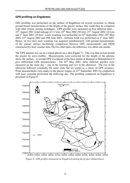
PETRI PELLIKKA AND KARI KAJUUTTI (ED)GPS profiling on EngabreenGPS profiling was performed on the surface of Engabreen on several occasions to obtainground-based measurements of the height of the glacier surface that could then be comparedwith other remote sensing techniques. GPS profiles were measured on four different dates –24 th August 2001 (total mileage of 11 km), 28 th May 2002 (94 km), 23 rd August 2002 (18 km)and 1 st June 2003 (29 km). Laser scanning was performed on 24 th September 2001, 28 th May2002, 23 rd August 2002 and 29th June 2003. Airborne SAR was performed on 1 st June 2003.Hence, on two days laser scanning was acquired simultaneously with ground measurementsof the glacier surface facilitating comparison between GPS measurements and DEMconstructed by laser scanner data. On two other dates, the difference was about one month.The GPS antenna was set on a tripod placed on a sled (Figure 7). This was then towed aroundthe glacier by snow-mobile. Measurements were corrected for the height of the antennaabove the surface. A second GPS was placed at the base station at Bautaen or Holandsfjord togive differential GPS measurements. On 28 th May 2002, three different profiles weremeasured on the same day – one in the morning and two in the afternoon. The two in theafternoon followed essentially the same route but are useful as a check on GPS accuracy.Point measurements were made on the glacier tongue on 23 rd September 2001 for comparisonwith laser scanning performed the following day. The profiling conducted on Engabreen ispresented in Figure 8.73990007398000Helgelandsbukken1454 mBautaen1217 mTåkeheimen1100 m7397000Møsbrømtuva1109 m73960007395000739400073930007392000StakeSkjæret1354 m7391000Aug 2001 GPS profileAug 2002 GPS profileSnøtindJun 2003 GPS profile1594 m7390000May 2002 p.m. GPS profile 1May 2002 p.m. GPS profile 2May 2002 a.m. GPS profile0 m 1000 m 2000 m7389000443000 444000 445000 446000 447000 448000 449000 450000 451000 452000 453000 454000Figure 8. GPS profiles measured on Engabreen during the project (dotted lines).19


