

1 Background - mountain.PROJECTS
1 Background - mountain.PROJECTS
1 Background - mountain.PROJECTS

Create successful ePaper yourself
Turn your PDF publications into a flip-book with our unique Google optimized e-Paper software.
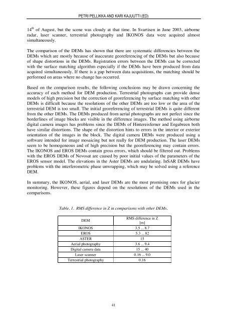
PETRI PELLIKKA AND KARI KAJUUTTI (ED)14 th of August, but the scene was cloudy at that time. In Svartisen in June 2003, airborneradar, laser scanner, terrestrial photography and IKONOS data were acquired almostsimultaneously.The comparison of the DEMs has shown that there are systematic differencies between theDEMs which are mostly because of inaccurate georeferencing of the DEMs but also becauseof shape distortions in the DEMs. Registration errors between the DEMs can be correctedwith the surface matching algorithm especially if the DEMs have been produced from dataacquired simultaneously. If there is a gap between data acquisitions, the matching should beperformed on areas where no change has occurred.Based on the comparison results, the following conclusions may be drawn concerning theaccuracy of each method for DEM production. Terrestrial photographs can provide densemodels of high precision but the correction of georeferencing by surface matching with otherDEMs is difficult because the resolutions of the other DEMs are too low or the area of theterrestrial DEM is too small. The initial georeferencing of terrestrial DEMs is quite differentfrom the other DEMs. The DEMs produced from aerial photographs are not perfect since theborderlines of image blocks are visible in the difference images. The method using airbornedigital camera images has problems since the DEMs of Hintereisferner and Engabreen bothhave similar distortions. The shape of the distortion hints to errors in the interior or exteriororientation of the images in the block. The digital camera DEMs were produced using asoftware intended for image mosaicing but not really for DEM production. The laser DEMsseem to be homogeneous and of high precision but the georeferencing may contain errors.The IKONOS and EROS DEMs contain gross errors, which should be filtered out. Problemswith the EROS DEMs of Novosat are caused by poor initial values of the parameters of theEROS sensor model. The elevations in the Aster DEMs are undulating. InSAR DEMs haveproblems with the interferometric phase unwrapping, which may be solved using a referenceDEM.In summary, the IKONOS, aerial, and laser DEMs are the most promising ones for glaciermonitoring. However, these figures depend on the resolutions of the DEMs used in thecomparisons.Table. 1. RMS difference in Z in comparisons with other DEMs.DEMRMS difference in Z[m]IKONOS 3.5 ... 8.7EROS 5.3 ... 82ASTER 15Aerial photography 3.6 ... 9.4Digital camera data 15 ... 40Laser scanner 0.16 ... 9.0Terrestrial photography 0.1641


