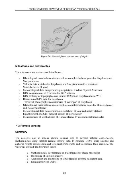
TURKU UNIVERSITY DEPARTMENT OF GEOGRAPHY PUBLICATIONS B Nr 4Figure 20. Hintereisferner contour map of depth.Milestones and deliverablesThe milestones and datasets are listed below:- Glaciological mass balance data over three complete balance years for Engabreen andStorglombreen- Velocity data at stakes for Engabreen and Storglombreen (3+ years) andSvartisheibreen (1 year)- Meteorological data (temperature, precipitation, wind) at Skjæret, Svartisen- GPS measurements of Svartisen for GCP network- GPS profiling of topography over total of 152 km on Engabreen [also WP3]- Reduction of GPR data for Engabreen- Terrestrial photography measurements of lower part of Engabreen- Glaciological mass balance data over three complete balance years for Hintereisfernerand Kesselwandferner- Meteorological data (temperature, precipitation) at Vent and nearby stations- Establishment of a GCP network around Hintereisferner- Measurements of ice thickness of Hintereisferner by ground penetrating radar4.3 Remote sensingSummaryThe project’s aim in glacier remote sensing was to develop refined cost-effectivemethodologies using satellite remote sensing data, to generate DEMs using satellite andairborne remote sensing data, and terrestrial photographs and to compare their accuracy. Thework was divided into four main tasks:ooooMethodological development and techniques for image processingProcessing of satellite imageryAcquisition and processing of terrestrial and airborne validation dataRelation between DEMs.28
PETRI PELLIKKA AND KARI KAJUUTTI (ED)Considering the user requirements, remote sensing techniques were tested and assessed fortheir appropriateness for long-term operational monitoring for European glacial areas.Spaceborne remote sensing techniques - especially very high-resolution optical images - wereconsidered to be applicable for continuous change detection in general, and, aerialphotogrammetry - including laser scanning and digital imaging - for cost effective andaccurate periodic inventory of both glacial area and volume, and terrestrial remote sensing forlocal validation of monitoring data. Spaceborne interferometric SAR technology can be usedfor short-term kinematic studies, whereas airborne interferometric SAR remains an unproventechnology, but with high potential for volumetric monitoring.Aim of the project and remote sensing activitiesThe aim of the OMEGA project is to develop an accurate long-term operational monitoringsystem for European glacial areas. The system will be used by glaciologists, but will bedeveloped in consultation with specialists in remote sensing and data processing. It will bedeveloped and tested on some of the glaciers of Svartisen in northern Norway, and onHintereisferner and Vernagtferner in the Central Eastern Alps in Austria.The aim of the remote sensing work package is to develop and refine cost-effectivemethodologies for glacier remote sensing using satellite remote sensing data, to generateDEMs using satellite and airborne remote sensing data, and terrestrial photographs and tocompare their accuracy. Several satellite remote sensing techniques were considered to beapplicable to the generation of digital elevation models (DEMs) and change detection inEuropean glacial areas: satellite stereophotogrammetry using spaceborne photographs(CORONA, KATE-200, KFA-1000), stereoplotting with optical scanner imagery (SPOT,JERS, EROS, IKONOS), methods of stereoradargrammetry using stereoscopic SAR imagesfrom ERS-1/2 and RADARSAT, and satellite radar interferometry (InSAR)4.3.1 Methodological developments and techniques for image processingGlaciological interpretation of satellite imageryThe aim of the work has been to test available methodology and develop new ones todelineate glacier borders and distinguish glacier zones of snow, firn and ice usingmultitemporal optical satellite images. The reliable delineation of glacier borders andclassification of glacier zones enables the interpretation of glaciological parameters, as well asglacier change detection. The main multitemporal data set consists of optical Landsat 4, 5 and7 TM and ETM+ images. ERS-1/2-INSAR data sets were used for experimenting withmicrowave imagery from different seasons (winter, spring, summer).The extreme elevation differences of the Alpine glaciers cause geometric and radiometricdistortion, such as relief displacements and slope and aspect effects. The dynamic range ofmost optical sensors is not optimised for the high reflectance of snow, and sensor saturationoften occurs. Much of the effort was directed into geometric and radiometric pre-processingfor the multitemporal interpretation of satellite images. Pre-processing steps includeorthorectification and radiometric normalisation due to atmosphere, topography and sensor29