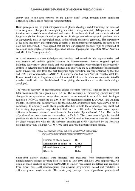
TURKU UNIVERSITY DEPARTMENT OF GEOGRAPHY PUBLICATIONS B Nr 4energy and to the area covered by the glacier itself, which brought about additionaldifficulties in the change mapping / documentation.Basic principles for the joint interpretation of glacier rheology and determining the areas ofextreme glacier changes in stereophotogrammetric, radargrammetric, lidargrammetric andinterferometric models were designed and tested. It has been decided that the estimation oflong-term glacier changes should be performed in the geo-coded cartographic products, suchas topographic and / or rheological maps, both available and newly generated. The importanceof identical geometry and comparable contents of multitemporal cartographic products to beused was underlined. It was agreed that all new cartographic products will be generated atscales and cartographic projections typical of national topographic maps (ÖK 50 for Austrianand M711 for Norwegian sites).A novel stereoorthophoto technique was devised and tested for the representation andmeasurement of surficial glacier changes in Hintereisferner. Several original optionsincluding radiometric, atmospheric and topographic corrections were designed and practicallyapplied to detecting marginal glacier changes and analysing the re-distribution of main glacierzones (snow, firn, ice) from the multitemporal high-resolution imagery obtained by the TMand ETM+ sensors from the LANDSAT 4, 5 and 7 as well as from ASTER-TERRA satellites.It was found that, in Engabreen, the determined ELA and the ablation area ratio (AAR)matched well with the field-derived ELA giving the confidence on the methodologydeveloped.The vertical accuracy of reconstructing glacier elevation (surficial) changes from airbornelidar measurements was given as ± 0.5 m. The accuracy of measuring glacier marginalchanges from spaceborne image data in areal terms ranged from ± 0.04 km² for highresolutionIKONOS models to ca. ± 0.15 km² for medium-resolution LANDSAT and ASTERmodels. The positional accuracy tests for the IKONOS orthoimage maps were carried out bycomparing 18 arbitrary stable check points identified in both the orthoimage map sheet andthe existing topographic map sheets ÖK50 in 1:50 000 scale. The root mean squaredifferences between measured co-ordinates is characterised by a value of 16.7 m. The resultsof positional accuracy tests are summarised in Table 3. The correctness of glacier terminiposition and the information contents of the IKONOS satellite image maps were also checkedby direct comparison with the old airborne orthoimages (1998) produced by the Austriannational survey and with the ALTM-4K02 semi-controlled airborne image mosaic.Table 3. Maximum errors between the IKONOS orthoimageand Austrian topographic maps on Hintereisferner.Number of check points 18Mean height of points, m 3358.5Mean difference, m 17.92RMS, m 16.66Short-term glacier changes were detected and measured from interferometric andlidargrammetric models covering both test sites in 1995-1996 and 2001-2003 respectively. Anoriginal phase gradient approach (GINSAR) to glacier rheological modelling and mappingfrom repeat pass SAR interferograms was devised, programmed, tested and validated indifferent glacier environments. The underlying concept, basic algorithms, processional46
PETRI PELLIKKA AND KARI KAJUUTTI (ED)singularities and the information contents were analysed. The technological efficiency andreliability of a new mapping chain was proved by experiments on 14 ERS-1/2 spaceborneinterferometric models and 6 stereoscopic models.The survey of glacier velocities using spaceborne remote sensing data was performed for thefirst time in the history of the exploration of Svartisen ice caps. The velocities of four outletglaciers were determined from spaceborne ERS-1/2 INSAR data obtained over the study sitein March 1996 using the original GINSAR technique designed by Joanneum Research.Horizontal velocities were surveyed at 7 to 11 surface points of Engabreen, Litlbreen,Storglombreen, Frukostindenbreen and Hintereisferner glaciers during three field campaignsin summers 2002, 2003 and compared with INSAR winter velocities. The tachometricdifferences revealed were explained by seasonal changes in glacier motion, different durationof observations, methodological imperfections and the influence of glacier melting and tiltingof separate ice blocks. The analysis of multitemporal spaceborne SAR and optical imageryprovided certain evidence on the character of the ice flow at test glaciers.The average tachometric accuracy of satellite rheological models for the Hintereisferner andSvartisen test sites was estimated at ± 2.0 cm/day. High metric quality and detail, consistentand complementary information contents, proportionally long legends, conformity withavailable standards, attractive appearance and the wide range of possible applications provideample proof that satellite rheological maps are to be regarded as full-value cartographicproducts. Interferometric models represented in the most complete, albeit concise and easilyinterpreted form are deemed to demonstrate clearly the functional quality and processionaladvantages of a new GINSAR technology ideally suited for automated glacier cartography.Taxonomy of glacier changesSemantic ordering and taxonomy of glacier changes was considered to be an inherent part ofthe glacier change interpretation. In glacier change analysis, one should distinguish betweengeometric changes (change of dimension, boundary reconfiguration and movement),topological changes such as splitting and joining, overlapping and suppressing, emergence ordisappearance of features, changes in the number of elements, and thematic state changes(changes of non-spatial attributes), seasonal (or temporary) and long-term (or steady)changes, typical and anomalous changes, binary (sharp, abrupt) and continuous (gradual)changes, significant (full or substantial), i.e. those of large magnitude or/and seriousimplications, and insignificant (minor) changes. Only significant, steady and typical longtermchanges of the glacier termini shall be recorded by glacier monitoring.In the OMEGA research, a simplified approach to the classification of marginal glacierchanges based on the observed gain or loss of ice, i.e. advance or retreat of glacier, is offered.In accordance with this principle all glacier borders are divided into four large groups: 1)stable glacier termini, 2) retreating glacier borders, 3) borders of advancing and surgingglaciers and 4) glacier margins with uncertain / unknown dynamics. Such a classificationsystem is morphologically neutral and does not require special thematic, e.g. bathymetricstudies. It necessitates a substantial knowledge about glacier evolution and velocities ofglacial flow, however, which can be gained from remote sensing studies comprising relativelyshort periods (from several days to several years) of observation. Besides, glacier changecategorisation may be based on the genetic (causal), structural or methodological principle.For instance, glacier changes were arranged in different classes according to their causes or47