English
The vast history of the territory of the Euro-Region Galicia and the North of Portugal has enabled the footprints of the different settlers to be still perceptible these days. It is enriching to be able to visit the prehistoric monuments of these regions, for a better understanding of how life centuries ago was.
The vast history of the territory of the Euro-Region Galicia and the North of Portugal has enabled the footprints of the different settlers to be still perceptible these days. It is enriching to be able to visit the prehistoric monuments of these regions, for a better understanding of how life centuries ago was.

Create successful ePaper yourself
Turn your PDF publications into a flip-book with our unique Google optimized e-Paper software.
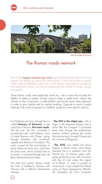
Of castros and romans<br />
Roman Bridge (Ourense)<br />
The Roman roads network<br />
One of the biggest engineering works that the Roman Empire left is the road<br />
network that ended up joining the furthest places of the empire with its capital.<br />
These roads contributed to give unity to the territory and made its occupation<br />
and exploitation easier, as well as to guarantee the mobility of troops, people<br />
and goods.<br />
These Roman roads were especially cared for, with a route that avoided the<br />
depths of valleys or peaks, always trying to keep a stable level, without big<br />
inclines. In their construction, a wide platform and several layers were disposed,<br />
in order to give stability and an optimal levelling. Opposite to what is usually<br />
believed, they were not paved nor cobbled, except for some specific sections.<br />
For Gallaecia we know, through the socalled<br />
Itinerary of Antonino, a true<br />
road map of the era, five main roads.<br />
The first one, the XVI, connected it<br />
towards the south, with Lusitania, since<br />
it joined Bracara with Olisipo, going<br />
through Santarém, (the conventual<br />
capital) and Aeminium (Coimbra). This<br />
road crossed all the municipality of<br />
Santa Maria da Feira and, north from<br />
the Duero river, which crossed close to<br />
its mouth, it continued through Leça de<br />
Balio (Matosinhos) and Maia.<br />
The other four joined, always inside<br />
the limits of Gallaecia, Bracara with<br />
Asturica with a different intermediate<br />
itinerary:<br />
- The XVII is the oldest one, with its<br />
origin in the Augustan dynasty and a<br />
while after the conquest- It connected<br />
these cities through the southernmost<br />
itinerary (without entering the current<br />
Galician territory), through Chaves and<br />
the vicinities of Bragança.<br />
- The XVIII was called Via Nova<br />
already in Roman times, what clearly<br />
indicates that it is posterior, from the<br />
Flavian era. Its itinerary goes north,<br />
going up the Limia river until it connects<br />
with the Sil and enters the region<br />
of el Bierzo. In order to protect its<br />
construction, it was created the military<br />
camp of Aquis Querquennis (Bande,<br />
50 kilometres far from Ourense),<br />
30