

Archeomatica International 2017
Special supplement to Archeomatica 3 2017
Special supplement to Archeomatica 3 2017

Create successful ePaper yourself
Turn your PDF publications into a flip-book with our unique Google optimized e-Paper software.
Cultural heritage Technologies 27<br />
collecting and cross-checking data (Ballatore and Bertolotto<br />
2011; McCall et al. 2015). It has been shown to be extremely<br />
useful in monitoring processing in several fields: vegetation<br />
cover (Guidry 2011), collecting and recording local names for<br />
rural areas (Rampl 2014), promoting environmental awareness<br />
and change (Spanu et al. 2015), and providing timely<br />
data that may otherwise be unavailable to policy makers in<br />
soil and water conservation management (Werts et al. 2012).<br />
The case study of Nurnet presents multiple reasons supporting<br />
the use of these technological resources to reach the<br />
main goal of the promotion and protection of cultural heritage<br />
in Sardinia. Firstly, there is an absolute need to collect<br />
better information in a territory where numbers and data are<br />
still imprecise.<br />
Data collection of the historical heritage of Sardinia of the<br />
Bronze Age is a constant ‘work in progress’; oftentimes the<br />
only way to get more information is to elicit local knowledge<br />
and gather the ‘historical memory’ of the people, seeking<br />
to understand the connections between names and places,<br />
that is, the relevant science of “toponomy”, defined by the<br />
UNGEGN, the United Nations Group of Experts on Geographical<br />
Names, as “Place names as intangible cultural heritage”<br />
(UNGEGN 2015).<br />
The people who know the territory most comprehensively<br />
and who can provide accurate information are the local<br />
people. Through webGIS and crowdsourcing therefore it is<br />
possible to collect detailed information about what is called<br />
“cultural natural landscape”, testifying to those places<br />
that represent the “combined works of nature and of man”<br />
(WHC 2015) and embracing a diversity of manifestations of<br />
the interactions between humankind and our natural environment.<br />
Information collection from local people is needed,<br />
in order to record the history and memory of the traditional<br />
cultural landscapes (WHC 1972). This cooperation between<br />
the two sets of actors, experts and local citizens, leads to<br />
another key point that is also one of the key statements of<br />
the project: the cultural identity of the local people, which<br />
is a component of cultural heritage and its protection. Indeed,<br />
while they are helping in the process of information<br />
collection, the local participants can rediscover their own roots<br />
and keep alive their cultural heritage, cultural landscape<br />
and memory (McCall et al. 2015), also making it available to<br />
younger generations. Consequently, the preservation and the<br />
monitoring of the historical sites also benefit.<br />
Preservation and monitoring<br />
In the operationalization of the Nurnet platform, the processes<br />
of preservation and monitoring of the archaeological sites<br />
are performed both by experts and local volunteers. Experts<br />
collect data and information, record the state of conservation<br />
of specific sites, structures and artifacts, monitor the various<br />
types of tourism and the expectations of visitors, analyse the<br />
impacts of visitors on sites and structures and the risks of<br />
deterioration and degradation, and suggest protection measures<br />
for the public bodies in charge of conservation.<br />
Local people and tourists contribute considerably to these<br />
processes: local people supplement and complement the basic<br />
information about the archaeological sites, but also because<br />
they live in the locality, they are the first people to<br />
recognize the state of conservation and any changes in the<br />
sites which require maintenance from technicians; tourists<br />
contribute to the preservation and monitoring processes as<br />
well, specifically because they have fresh eyes and externally-formed<br />
opinions. Because they visit a site for the first<br />
time or only occasionally, they notice things from an external<br />
(visitor’s) point of view: the state of conservation, comparisons<br />
with other places they have visited, hints on how a place<br />
might be valued by other visitors, services needed to allow<br />
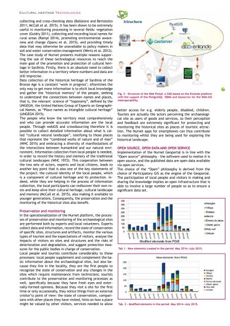
Fig. 2 - Structure of the Web Portal: a CMS based on the Entando platform<br />
with the support of the PostgreSQL DBMS and Geoserver for the Web-GIS<br />
interoperability.<br />
better access for e.g. elderly people, disabled, children.<br />
Tourists are actually the actors perceiving the archaeological<br />
site as users of goods and services, so their perception<br />
and feedback are extremely significant for protecting and<br />
monitoring the historical sites as places of touristic attraction.<br />
The Nurnet apps for smartphones can thus contribute<br />
to monitoring whilst they are being used for exploring the<br />
historical landscape.<br />
OPEN SOURCE, OPEN DATA AND OPEN SERVICE<br />
Implementation of the Nurnet Geoportal is in line with the<br />
“Open source” philosophy - the software used to realize it is<br />
open source, and the published data are open data available<br />
via open services.<br />
The choice of the “Open” philosophy is derived from the<br />
choice of Participatory GIS as the engine of the Geoportal.<br />
The participation of local people and visitors in making and<br />
sharing the knowledge implies an open infrastructure that is<br />
able to involve a large number of people so as to ensure a<br />
significant data set.<br />
Tab.1 - New elements created in the period May 2014--July 2015.<br />
Tab. 2 - Modified elements in the period May 2014--July 2015.


