

Archeomatica International 2017
Special supplement to Archeomatica 3 2017
Special supplement to Archeomatica 3 2017

You also want an ePaper? Increase the reach of your titles
YUMPU automatically turns print PDFs into web optimized ePapers that Google loves.
Cultural heritage Technologies 29<br />
of Nuragic and pre-Nuragic period. Furthermore, a user data<br />
request can have his geolocation.<br />
The analysis of the user data requests can contribute to the<br />
development and selection of indicators regarding the attractiveness<br />
of the sites, other than only the site-accessibility<br />
indicator; and this can help identify their potentials as<br />
economically-valuable touristic resources.<br />
This approach to evaluating the attractiveness of the archeological<br />
sites is essentially empirical, therefore CRS4 and the<br />
Nurnet Foundation are working to implement a statistical<br />
model based on structured data related to tourist access and<br />
available tourist services.<br />
FUTURE DEVELOPMENTS AND CONCLUSIONS<br />
Main objective of the Geoportal is the promotion of the cultural<br />
heritage landscape in Sardinia.<br />
Future works may include providing more than one language<br />
for the textual descriptions and the implementation of<br />
a statistical tool, a sort of decision support system, to help<br />
the managers of archeological sites to diagnose the attractiveness<br />
of a site, the changes over time, and comparisons<br />
with managed and unmanaged sites. Finally the API of the<br />
geoportal will be extended to better manage the feedback<br />
from users.<br />
There are many social webs that permit to create and share<br />
GIS data (e.g. Wikimapia, OpenStreetMap, Google, etc.). The<br />
main idea of Nurnet Geoportal is to create a more accurate<br />
and reliable database with a better taxonomy and descriptions<br />
of the sites, which will be built on the inputs of the<br />
population living in the territory.<br />
The results obtained highlight that the participatory process<br />
is a bottom-up approach: it is linked to a local territory and<br />
to an issue realized through the direct involvement of local<br />
NGOs in the data management and they will be the organizations<br />
who will use the data in order to manage a sustainable<br />
tourism in the sites interesting from an archaeological point<br />
of view. It is also very important to detect where the tourist<br />
attractions are not easily accessible to people (Demontis<br />
et al. 2013). This approach gives positive results in terms of<br />
quantity and quality of the data, and in terms of involving<br />
the local population in the production of the data, and thus<br />
helping to empower them.<br />
The methodology employed is flexible and replicable for<br />
other territories and for other topics.<br />
Finally the Geoportal can be managed in a cloud environment<br />
at a relatively low cost. Its success in terms of user access<br />
can generate a lot of useful information for the analysis of<br />
tourism flows and for regional spatial economic management.<br />
Bibliography<br />
Ballatore, A., & Bertolotto, M. (2011). Semantically enriching VGI in support<br />
of implicit feedback analysis. In Web and Wireless Geographical Information<br />
Systems (pp. 78-93). Springer Berlin Heidelberg.<br />
Cuca, B., Brumana, R., & Oreni, D. (2013, August). Geo-portals: more sustainable<br />
governance of territory within spatial data framework. In First <strong>International</strong><br />
Conference on Remote Sensing and Geoinformation of Environment<br />
(pp. 87950G-87950G). <strong>International</strong> Society for Optics and Photonics.<br />
Cuca, B., Oreni, D., & Brumana, R. (2012, September). Digital cartographic<br />
heritage in service to the society: Landscape analysis for informed decision<br />
making. In Virtual Systems and Multimedia (VSMM), 2012 18th <strong>International</strong><br />
Conference on (pp. 499-506). IEEE.<br />
Demontis, R., Lorrai, E. B., Muscas, L., DeMarr, M., Estabrook, S. (2013).<br />
Cost function for route accessibility with a focus on disabled people confined<br />
to a wheelchair: the TOURRENIA Project.<br />
29th Urban Data Management Symposium, London, May , page 7--13 – 2013.<br />
Fernández-Wyttenbach, A., Álvarez, M., Bernabé-Poveda, M., & Borbinha,<br />
J. (2007). Digital map library services in the spatial data infrastructure (sdi)<br />
framework: The digmap project. In Proceedings of the 23th <strong>International</strong><br />
Conference in Cartography. <strong>International</strong> Cartographic Association (ICA-<br />
ACI). Moscow,(Russia) August (pp. 4-10).<br />
Guidry, L. (2011). Using WebGIS and Crowdsourcing to Locate an Invasive<br />
Species in Pima County, Arizona.<br />
Karabegovic, A., & Ponjavic, M. (2012, September). Geoportal as decision<br />
support system with spatial data warehouse. In Computer Science and Information<br />
Systems (FedCSIS), 2012 Federated Conference on (pp. 915-918).<br />
IEEE.<br />
Lilliu, G. (2006). Sardegna Nuragica, Edizioni Maestrali.<br />
McCall, M. K., Martinez J. and Verplanke J. (2015). Shifting boundaries of<br />
Volunteered Geographic Information systems and modalities: Learning from<br />
PGIS. ACME An <strong>International</strong> E-Journal for Critical Geographies 14.Nurnet<br />
geoportal address http://nurnet.crs4.it/nurnetgeo/.<br />
Pictures and maps have been taken from Nurnet Geoportal and website of<br />
Nurnet Foundation.<br />
Ontario Heritage Trust (2012). Cultural Heritage Landscape- An introduction.<br />
www.heritagetrust.on.ca Rampl, G. (2014). Crowdsourcing and GIS-based<br />
Methods in a Field Name survey in Tyrol (Austria), United Nations Group<br />
of Experts on Geographical Names, Working Paper NO. 16/9, Twenty-eight<br />
session, 28 April – 2 May 2014, Item 9 of the Provisional Agenda Activities<br />
relating to the Working Group on Toponymic Data Files and Gazetteers.<br />
Regione Sardegna Geoportale (2013), http://www.sardegnageoportale.it/<br />
webgis2/sardegnamappe/?map=base<br />
Spanu, V., Gaprindashvili, G., McCall, M. K. (2015). Participatory Methods in<br />
the Georgian Caucasus: Understanding Vulnerability and Response to Debrisflow<br />
Hazards. <strong>International</strong> Journal<br />
of Geosciences 6 (7), 666-674<br />
United Nations Group on Geographical Names- Romano- Hellenic Division<br />
(2015), <strong>International</strong> scientific symposium, Place names as intangible cultural<br />
heritage, Firenze – Italy, 26th - 27th<br />
March 2015<br />
Werts, J. D., Mikhailova, E. A., Post, C. J., & Sharp, J. L. (2012). An integrated<br />
WebGIS framework for volunteered geographic information and social<br />
media in soil and water conservation.<br />
Environmental management, 49(4), 816-832.<br />
Wikimapia (2013), http://wikimapia.org/#lang=it&lat=39.622615&lon=9.2<br />
25769&z=9&m=b&tag=37157<br />
Wikipedia (2015), https://en.wikipedia.org/wiki/Nuragic_civilization<br />
World Heritage Convention (1972), Convention Concerning the Protection<br />
of the World Cultural<br />
and Natural Heritage Adopted by the General Conference at its seventeenth<br />
session, Paris, 16<br />
november 1972.<br />
Abstract<br />
CRS4 (Center for Advanced Studies, Research and Development in Sardinia) developed<br />
the Geoportal Nurnet (http://nurnet.crs4.it/nurnetgeo/) to manage<br />
and share information about the Bronze Age in Sardinia (Italy).<br />
The scope of this paper is to explain how the Geoportal Nurnet (net of Nuraghes,<br />
the typical Sardinian building from the Bronze Age) has been developed<br />
to promote the Bronze Age culture in Sardinia, identified in the Pre-Nuragic<br />
(3200−2700 BC) and Nuragic (up to the 2nd century AD) civilization. It is<br />
fed by a net of conventional social connections and social web networks empowered<br />
by private citizens, agents and public administrations sharing the same<br />
goals and interests.<br />
Keywords<br />
cultural heritage landscape; public participatory gis; geoportal;<br />
Sardinia; archaeology<br />
Authors<br />
Valentina Spanu<br />
valespanu@crs4.it<br />
Eva Barbara Lorrai<br />
eva@crs4.it<br />
Laura Muscas<br />
muscas@crs4.it<br />
Roberto Demontis<br />
demontis@crs4.it<br />
CRS4 (Centro di Ricerca, Sviluppo e Studi Superiori in Sardegna)<br />
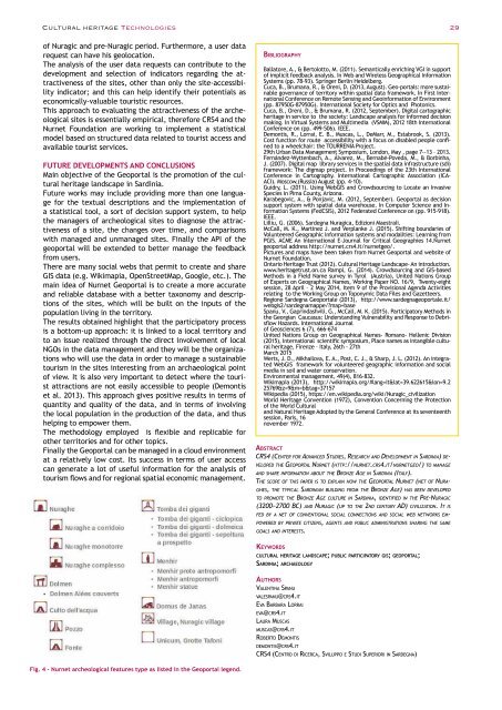
Fig. 4 - Nurnet archeological features type as listed in the Geoportal legend.


