

Archeomatica International 2017
Special supplement to Archeomatica 3 2017
Special supplement to Archeomatica 3 2017

Create successful ePaper yourself
Turn your PDF publications into a flip-book with our unique Google optimized e-Paper software.
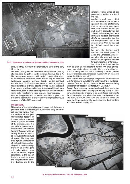
Fig. 9 - Photo-mosaic of ancient Ostia, Aeronautica Militare photographs, 1960.<br />
dens, and they fit well in the architectural taste of the early<br />
XX century.<br />
The SARA photographs of 1934 show the systematic planting<br />
of pines along the path of the Decumanus Maximus (Fig. 8-9).<br />
The turning point happened with the E42 project, that joined<br />
to the extensive excavation of the ancient city an ambitious<br />
landscaping program, overseen directly by the architect<br />
Michele Busiri Vici 18 which was meant to include originally<br />
massive plantings of trees, both to provide shadow and relief<br />
from the sun to visitors and to help in the readability of some<br />
monuments, such as the harbor supposed on the left embankment,<br />
to be recalled by a wood that was never realized.<br />
Afterwards cypresses will be used to recall the original position<br />
of the lost columns of the Forum outside porta Marina, as<br />
appears in a SARA 1983 photograph.<br />
CONCLUSIONS<br />
This review of the aerial photograph imagery of Ostia over a<br />
period of more than seventy years, allows to carry on different<br />
readings, ranging from<br />
the analysis of the geomorphological<br />
features of<br />
the area to the assessment<br />
of the impact of the works<br />
of the archaeologists. It is<br />
particularly interesting to<br />
evaluate this last factor of<br />
human influence: while we<br />
usually think to excavation<br />
as the systematic analysis<br />
of layers, this study does<br />
shed light on the footprint<br />
of such activities. Archaeological<br />
activities emerge<br />
therefore as the last (and<br />
still today visible) layer<br />
of an incredibly complex<br />
palimpsest. In the case of<br />
Ostia it is possible to see<br />
this footprint in the selective<br />
diggings and in the<br />
extensive works aimed at the<br />
preservation and landscaping of<br />
the site.<br />
Another crucial aspect that<br />
must be noted is the different<br />
approach to aerial photography<br />
that archaeologits have taken<br />
over time. While in the first period<br />
(and in particular for the<br />
‘rilievo’ by Dante Vaglieri) aerial<br />
imagery has been approached<br />
chiefly as topographic tool for<br />
the management of sites, in the<br />
decades after WWII the interest<br />
has shifted toward landscape<br />
studies.<br />
For sure the turning point<br />
matches the development of<br />
Aerial and Landscape Archaeology<br />
after the war, and can be<br />
linked to the specific interest<br />
for such disciplines of former Allied<br />
pilots. A particular mention<br />
must be given to John Bradford: former RAF pilot, photographer<br />
and photo-interpreter, after the end of wartime operations,<br />
being attached to the University of Oxford, he did<br />
pioneer archaeological landscape studies with an extensive<br />
use of the Allied material. 19<br />
After the war aerial photograph imagery will be used also to<br />
look for elements useful for the understanding of the topography<br />
of Ostia and Portus, the most famous example being<br />
the search for traces of the harbour of Claudius. 20<br />
Overall Ostia is, among the archaeological sites, one of the<br />
most covered by aerial photographs in Italy during XX century,<br />
allowing aerial imagery to be a privileged instruments<br />
for archaeologists to study the birth and development of the<br />
site itself, its natural landscape, and try to read in the soil<br />
some marks whispering us the stories that one day those hills<br />
and fields will tell us (Fig. 10).<br />
Fig. 10 - Photo-mosaic of ancient Ostia, SAF photographs, 1964.<br />
34 ArcheomaticA <strong>International</strong> Special Issue


