

Archeomatica International 2017
Special supplement to Archeomatica 3 2017
Special supplement to Archeomatica 3 2017

Create successful ePaper yourself
Turn your PDF publications into a flip-book with our unique Google optimized e-Paper software.
Cultural heritage Technologies 31<br />
Ostia will see another campaign of aerial photography in 1934<br />
by the SARA company, and during WWII will be covered twice<br />
by the runs of the British Royal Air Force (RAF), in 1943 and<br />
1944. In the second half of the XX century we have three<br />
photographic campaigns by the SARA company under different<br />
names: ETA in 1953; SAF in 1964; again SARA in 1983. The<br />
Geographic Institute of the Italian Aviation has covered the<br />
area of Ostia in two different runs: 1957 and 1960.<br />
Catalogue of<br />
the studied<br />
material<br />
Year Author Frames<br />
1911 Italian Army 1<br />
1934 S.A.R.A.<br />
2<br />
(Società per Azioni Rilevamenti<br />
Aerofotogrammetrici)<br />
1943 British Royal Air Force 1<br />
1944 British Royal Air Force 1<br />
1953 E.T.A. 2<br />
1957 Italian Air Force 1<br />
1960 Italian Aviation 2<br />
1964 S.A.F. 3<br />
1983 S.A.R.A. 1<br />
fIG. 2 - “Rilievo topofotografico dal pallone” (1911), with the Dead River (‘fiume<br />
morto’) pointed out.<br />
DANTE VAGLIERI AND THE RILIEVO TOPOFOTOGRAFICO<br />
The arrival, in 1907, of Dante Vaglieri 4 to the direction of the<br />
Office for the excavations at Ostia starts a new chapter in the<br />
history of the research in the site 5 . Vaglieri arrives in an area<br />
which has seen for century spoliations, depredations and by<br />
the XVIII century excavations conceived as treasure hunts to<br />
feed the enormous market of antiquities, whose fortune increased<br />
impressively with the spread of neoclassical taste 6 .<br />
The result of the activities carried out in the area for centuries<br />
was a site marked by the presence of isolated groups<br />
of ruins, separated by hills shaped by the still interred buildings,<br />
with a substantial lack of knowledge of the urbanization<br />
and history of the ancient city in its complex.<br />
The answer of Dante Vaglieri to this condition consisted in<br />
the development of a real program of works, enunciated in<br />
his foreword to Lodovico Paschetto’s book Ostia colonia romana<br />
(Paschetto 1912). “My program is threefold, and under<br />
these three points of view I will consider this excavation: 1)<br />
complete the excavation of the partially digged out buildings,<br />
taking care in the meanwhile of the preservation of all<br />
the ruins previously unearthed; 2) connect isolated groups<br />
of ruins; 3) through deep excavations and through analysis,<br />
bring light on the development of the history of Ostia” 7 .<br />
Dante Vaglieri, well fitting in the cultural milieu of positivism,<br />
was particularly enthusiast of technological novelties:<br />
needing for his project a detailed knowledge of the site and<br />
its topography, he made request in 1911 to the Ministry of<br />
War of a ‘topophotographic relief’ of the site, such as the<br />
one realized during the year before in Pompeii, suitable also<br />
as cartographic base.<br />
By the analysis of this huge photomosaic, we can individuate<br />
the different isolated nuclea of ruins: the area N of the<br />
Forum along the Cardo Maximus [1]; the area around the Decumanus<br />
Maximus with the Theatre, the Baths of Neptunus<br />
and the necropolis outside porta Romana [2]. Easily recognizable<br />
are as well: the tombs of the necropolis outside porta<br />
Laurentina [3], digged by Carlo Lodovico Visconti between<br />
1855 and 1857, and under further investigation at the time of<br />
the relief; the Terme Marittime [4], built along the track of<br />
the republican walls; the Terme della Marciana [5] (digged by<br />
the Scottish painter Gavin Hamilton between 1774 and 1775 8 ,<br />
and again by Giovanni Pietro Campana between 1831 and<br />
1835), still called with the traditional name of Porta Marina,<br />
even if in the photomosaic the walls appear clearly distant;<br />
the temple of Cybele [6] (digged by Visconti between 1867<br />
and 1869), even if the whole complex is still not recognizable<br />
in its integrity; the enormous complex of the so-called<br />
Palazzo Imperiale [7], digged out by Visconti as well.<br />
E42: THE BIRTH OF THE ARCHAEOLOGICAL AREA<br />
As Vaglieri couldn’t fulfill his program (he died while working<br />
in his office during the night between December 12th and<br />
13th 1913), for some years there is no progress in aerial photographic<br />
documentation. With the only interruption of the<br />
years of WWI and the immediate aftermath, the methodic<br />
exploration of the ancient city was continued by Guido Calza 9<br />
(director of the site by 1924 onward) and Italo Gismondi 10 : an<br />
archaeologist and an architect, whose joint efforts and vision<br />
gave to Ostia the shape that we still can see visiting the site.<br />
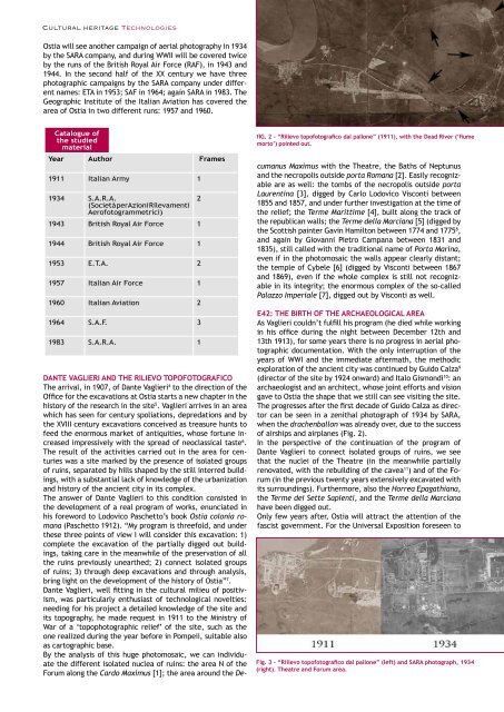
The progresses after the first decade of Guido Calza as director<br />
can be seen in a zenithal photograph of 1934 by SARA,<br />
when the drachenballon was already over, due to the success<br />
of airships and airplanes (Fig. 2).<br />
In the perspective of the continuation of the program of<br />
Dante Vaglieri to connect isolated groups of ruins, we see<br />
that the nuclei of the Theatre (in the meanwhile partially<br />
renovated, with the rebuilding of the cavea 11 ) and of the Forum<br />
(in the previous twenty years extensively excavated with<br />
its surroundings). Furthermore, also the Horrea Epagathiana,<br />
the Terme dei Sette Sapienti, and the Terme della Marciana<br />
have been digged out.<br />
Only few years after, Ostia will attract the attention of the<br />
fascist government. For the Universal Exposition foreseen to<br />
Fig. 3 - “Rilievo topofotografico dal pallone” (left) and SARA photograph, 1934<br />
(right). Theatre and Forum area.


