

Archeomatica International 2017
Special supplement to Archeomatica 3 2017
Special supplement to Archeomatica 3 2017

You also want an ePaper? Increase the reach of your titles
YUMPU automatically turns print PDFs into web optimized ePapers that Google loves.
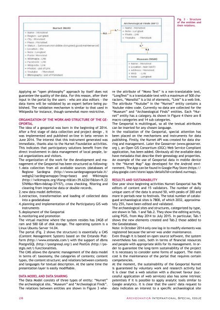
Fig. 3 - Structure<br />
of the entities and<br />
their relations.<br />
Applying an “open philosophy” approach by itself does not<br />
guarantee the quality of the data. For this reason, after their<br />
input in the portal by the users - who are also editors - the<br />
data items will be validated by an expert before being published.<br />
The validation mechanism is similar to that used in<br />
Wikipedia for instance, though somewhat more restrictive.<br />
ORGANIZATION OF THE WORK AND STRUCTURE OF THE GE-<br />
OPORTAL<br />
The idea of a geoportal was born in the beginning of 2014.<br />
After a first stage of data collection and project design , it<br />
was implemented and published on-line in beta version in<br />
June 2014. The interest that this instrument generated was<br />
immediate, thanks also to the Nurnet Foundation activities.<br />
This indicates that participatory solutions benefit from the<br />
direct involvement in data management of local people, local<br />
organizations and visitors.<br />
The organization of the work for the development and management<br />
of the Geoportal has been structured as following:<br />
1. data collection from all available sources (databases of<br />
Regione Sardegna (http://www.sardegnageoportale.it/<br />
webgis2/sardegnamappe/?map=base) and Wikimapia<br />
(http://wikimapia.org/#lang=it&lat=39.622615&lon=9.22<br />
5769&z=9&m=b&tag=37157), cross checking, filtering and<br />
cleaning from imprecise data or double records,<br />
2. new data model definition,<br />
3. extraction, transformation and loading of collected data<br />
into a geodatabase<br />
4. planning and implementation of the Participatory GIS web<br />
instruments<br />
5. deployment of the Geoportal<br />
6. monitoring and promotion<br />
The virtual machine where the system resides has 24GB of<br />
ram and 500 GB of disk storage. The operating system is a<br />
Linux Ubuntu Server 14.04.<br />
The portal (Fig. 2 shows the structure) is essentially a CMS<br />
(Content Management System) based on the Entando Platform<br />
(http://www.entando.com/) with the support of dbms<br />
PostgreSQL (http://postgresql.org/) and PostGis (http://postgis.net/)<br />
functionalities.<br />
The CMS allows the dynamic management of the data model<br />
in terms of: taxonomy, the categories of contents; content<br />
types, the content structure; and relations between contents<br />
and languages for textual description. At the same time the<br />
presentation layer is easily modifiable.<br />
DATA MODEL AND DATA SHARING<br />
The Data Model consists of three types of entity: “Nurnet”<br />
the archeological site, “Museum” and “Archeological Finds”.<br />
The relations between entities are shown in Figure 3 where<br />
the attribute of “Mono Text” is a non-translatable text,<br />
“LongText” is a translatable text with a maximum of 500 characters,<br />
“Monolist” is a list of elements, “Link” is a web link.<br />
The attribute “Youtube” in the “Nurnet” entity contains a<br />
Youtube video code. Currently no data are collected for the<br />
“Museum” and “Archaeological Finds” entities. Each “Nurnet”<br />
entity has a category. As shown in Figure 4 there are 8<br />
macro categories and 14 sub categories.<br />
The Geoportal is multilingual, so all the textual attributes<br />
can be inserted for any chosen language.<br />
In the realization of the Geoportal, special attention has<br />
been placed on the mechanisms and instruments for data<br />
publishing. Firstly, the Nurnet API was created for data sharing<br />
and management. Later the Geoserver (www.geoserver.<br />
org ), an Open GIS Consortium (OGC) Web Service Compliant<br />
application, has been added. Obviously all the available data<br />
have metadata that describe their genealogy and properties.<br />
An example of the use of Geoportal data in mobile device<br />
is the “Nurnet Map” App developed for the Android environment.<br />
The App can be found in Google Play Store (https://<br />
play.google.com/store/apps/details?id=cordand.nurmap).<br />
RESULTS AND SUSTAINABILITY<br />
One year since beginning activities Nurnet Geoportal has 96<br />
editors of content and 15 validators. The number of daily<br />
unique users of the data is around 50, with peaks of 200 and<br />
more in periods near to festivals. The total number of catalogued<br />
archaeological sites is 7800, of which 2032, approximately<br />
25%, have been edited and validated.<br />
The archaeological sites and structures, categorized by type,<br />
are shown in Tab. 1 and Tab.2. They show the editing activity,<br />
using PGIS, from May 2014 to July 2015. In particular, Tab.1<br />
shows the new elements created and Tab.2 those added to<br />
the Geodatabase.<br />
Note: in October 2014 only one log-in to modify elements was<br />
registered because the server was under maintenance.<br />
Even though it is based on open source software, the system<br />
nevertheless has costs, both in terms of financial resources<br />
and people with appropriate skills for its management. In order<br />
to guarantee the long-term sustainability of the project<br />
it is necessary to consider some forms of support. The main<br />
cost is the maintenance of the portal that requires certain<br />
competencies.<br />
At the moment, the sustainability of the Geoportal Nurnet<br />
is guaranteed by voluntary work and research activity but<br />
it is clear that a web solution with a discreet favour (successful<br />
application of web services) also has some intrinsic<br />
potentials if it is possible to apply analytic tools similar to<br />
Google analytics. It is clear that the users’ data request to<br />
data indicates an interest to a specific archaeological site<br />
28 ArcheomaticA <strong>International</strong> Special Issue


