Water as Leverage- Setting the scene for a call for action
- No tags were found...
Create successful ePaper yourself
Turn your PDF publications into a flip-book with our unique Google optimized e-Paper software.
<strong>Water</strong> <strong>as</strong> <strong>Leverage</strong> <strong>for</strong> Resilient Cities Asia <strong>Setting</strong> <strong>the</strong> Scene <strong>for</strong> a Call <strong>for</strong> Action Content<br />
1.2.1<br />
Historical Drainage System<br />
Chennai’s hundreds of connected ponds, temple<br />
tanks, extensive wetlands and lakes were<br />
histori<strong>call</strong>y used <strong>as</strong> water b<strong>as</strong>ins <strong>for</strong> irrigation and<br />
still serve <strong>as</strong> flood accommodators. This ingenious<br />
system captured rainwater and protected <strong>the</strong> city<br />
from fl<strong>as</strong>h floods. After <strong>the</strong> water bodies lost <strong>the</strong>ir<br />
function <strong>for</strong> irrigation, people failed to recognize <strong>the</strong><br />
o<strong>the</strong>r services this system delivered to <strong>the</strong> city. The<br />
rivers still function relatively well <strong>as</strong> drains, but <strong>the</strong><br />
encroachment of ponds, wetlands and canals h<strong>as</strong><br />
reduced <strong>the</strong>ir drainage capacity to a minimum, while<br />
solid w<strong>as</strong>te and illegal constructions cause many of<br />
<strong>the</strong> canals and rivers to clog. This is one of <strong>the</strong> main<br />
issues related to <strong>the</strong> major floods that occur every<br />
few years. In addition, siltation of <strong>the</strong> river mouths<br />
blocks <strong>the</strong> water flow towards <strong>the</strong> sea, b<strong>as</strong>i<strong>call</strong>y<br />
making <strong>the</strong> rivers stagnant.<br />
<strong>the</strong> tap water chain. However, most buildings<br />
in Chennai individually pump consumption<br />
water from great depths under <strong>the</strong> city, hence<br />
affecting <strong>the</strong> underground and its natural water<br />
system. By shortcutting <strong>the</strong> system <strong>the</strong> natural<br />
water balance in <strong>the</strong> underground is distorted:<br />
too little rainwater infiltrates to recharge <strong>the</strong><br />
superficial and deep aquifers under <strong>the</strong> city.<br />
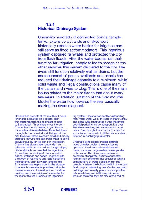
The railway station in <strong>the</strong> Buckingham Canal.<br />
Canal used <strong>for</strong> navigation<br />
Encroachment by<br />
illegal housing<br />
Landfil<br />
Pollution<br />
and solid w<strong>as</strong>te<br />
Rainwater storage pond<br />
Agriculture<br />
irrigated by ponds<br />
Bridge<br />
p<strong>as</strong>t<br />
present<br />
The Buckingham Canal<br />
h<strong>as</strong> been encroached<br />
by infr<strong>as</strong>tructure, landfill<br />
and housing.<br />
Chennai h<strong>as</strong> its roots at <strong>the</strong> mouth of Cooum<br />
River and is situated on a co<strong>as</strong>tal plain<br />
that stretches from <strong>the</strong> sou<strong>the</strong><strong>as</strong>t of India<br />
to Bangladesh. Three rivers cross <strong>the</strong> city:<br />
Cooum River in <strong>the</strong> middle, Adyar River in<br />
<strong>the</strong> south and Kos<strong>as</strong>thalaiyar River that flows<br />
through <strong>the</strong> nor<strong>the</strong>rn industrial fringes of <strong>the</strong><br />
city. However, <strong>the</strong>se rivers are small and mostly<br />
stagnant, carrying too little fresh water to serve<br />
<strong>as</strong> water supply <strong>for</strong> <strong>the</strong> city. For this re<strong>as</strong>on,<br />
Chennai h<strong>as</strong> always been dependent on<br />
rainwater. With <strong>the</strong> city built on a slight slope,<br />
city inhabitants constructed <strong>the</strong> ingenious<br />
Ery system, consisting of interconnected<br />
b<strong>as</strong>ins, wetlands and canals. Toge<strong>the</strong>r with<br />
a network of reservoirs and local harvesting<br />
mechanisms, such <strong>as</strong> water temples, <strong>the</strong><br />
Ery system w<strong>as</strong> responsible <strong>for</strong> <strong>the</strong> storage<br />
of <strong>as</strong> much rainwater <strong>as</strong> possible during <strong>the</strong><br />
monsoon se<strong>as</strong>on, <strong>the</strong> restoration of shallow<br />
aquifers and <strong>the</strong> provision of freshwater <strong>for</strong><br />
<strong>the</strong> rest of <strong>the</strong> year. Besides <strong>the</strong> ingenious<br />
Ery system, Chennai h<strong>as</strong> ano<strong>the</strong>r <strong>as</strong>tounding<br />
man-made water work: <strong>the</strong> Buckingham Canal.<br />
This canal w<strong>as</strong> constructed during <strong>the</strong> British<br />
colonial period <strong>for</strong> cargo transport. It is over<br />
700 kilometers long and connects <strong>the</strong> three<br />
rivers. Even though it h<strong>as</strong> lost its function <strong>for</strong><br />
water-b<strong>as</strong>ed transport, it still h<strong>as</strong> an important<br />
function in discharging rainwater.<br />
Chennai’s gentle slope crosses different<br />
types of water bodies: <strong>the</strong> water b<strong>as</strong>ins<br />
upstream, <strong>the</strong> rivers and canals between<br />
<strong>the</strong>se b<strong>as</strong>ins and large wetland are<strong>as</strong> parallel<br />
to <strong>the</strong> co<strong>as</strong>t. The city’s water system is a<br />
collection of separate, but interconnected,<br />
functioning complexes that consist of varying<br />
compositions of water bodies. Within this<br />
complex system, <strong>the</strong> buildings within <strong>the</strong> urban<br />
fabric play an interesting role. On <strong>the</strong> one hand,<br />
buildings can normally play a modest positive<br />
role in catching and infiltrating rainwater,<br />
while on <strong>the</strong> o<strong>the</strong>r <strong>the</strong>y are also at <strong>the</strong> end of<br />
Encroachments by real estate developments. The small islands are<br />
attempts to create mirco biotopes in this pond.<br />
Activities by <strong>the</strong> waterfronts are common,<br />
whe<strong>the</strong>r by <strong>the</strong> rivers, wetlands or by <strong>the</strong> beach.<br />
Connection ditch<br />
disappeared<br />
Overflow ditch<br />
Solid w<strong>as</strong>te<br />
Encroachment<br />
Pond removed <strong>for</strong><br />
urban development<br />
Fishing, bathing, cooking<br />
High turnover of inhabitants<br />
= low social connectivity<br />
The Erie system is a<br />
way to store surplus<br />
water during <strong>the</strong> monsoon<br />
se<strong>as</strong>on. Much of<br />
it h<strong>as</strong> disappeared and<br />
existing ponds are in a<br />
bad shape.<br />
154 CHENNAI<br />
<strong>Water</strong> Issues<br />
PART 2/Background In<strong>for</strong>mation on <strong>the</strong> Partner Cities<br />
155


