Water as Leverage- Setting the scene for a call for action
- No tags were found...

Create successful ePaper yourself
Turn your PDF publications into a flip-book with our unique Google optimized e-Paper software.
<strong>Water</strong> <strong>as</strong> <strong>Leverage</strong> <strong>for</strong> Resilient Cities Asia <strong>Setting</strong> <strong>the</strong> Scene <strong>for</strong> a Call <strong>for</strong> Action Content<br />
3.1.1<br />
Doubling <strong>the</strong> City<br />
Located on <strong>the</strong> nor<strong>the</strong>rn co<strong>as</strong>t of central Java,<br />
<strong>the</strong> most densely populated island of Indonesia,<br />
Semarang is <strong>the</strong> largest city in <strong>the</strong> province and<br />
<strong>the</strong> fifth largest in <strong>the</strong> country. After <strong>the</strong> Jakarta<br />
metropolitan area, Semarang is <strong>the</strong> largest city<br />
on Java’s nor<strong>the</strong>rn co<strong>as</strong>t. It covers an estimated<br />
area of 737.8 square kilometers between <strong>the</strong> Java<br />
Sea and higher hinterland and h<strong>as</strong> a population of<br />
approximately 1.8 million people in <strong>the</strong> urban area<br />
and over 3.9 million inhabitants in <strong>the</strong> metropolitan<br />
area.<br />
Originally a Javanese settlement, <strong>the</strong> first<br />
settlements in <strong>the</strong> Semarang area were<br />
strategi<strong>call</strong>y positioned; protected in <strong>the</strong><br />
e<strong>as</strong>t and west by rivers, in <strong>the</strong> north by<br />
<strong>the</strong> mangrove <strong>for</strong>est and in <strong>the</strong> south by<br />
mountains. In recent years, expansion h<strong>as</strong><br />
been oriented towards <strong>the</strong> elevated are<strong>as</strong> in<br />
<strong>the</strong> island’s interior. Interestingly, <strong>the</strong> small<br />
hill of Koenokoeni, which is considered one<br />
of <strong>the</strong> most prestigious residential locations<br />
in Semarang today, used to be a Chinese<br />
cemetery until <strong>the</strong> l<strong>as</strong>t century.<br />
Because of its excellent location 300<br />
kilometers e<strong>as</strong>t of Jakarta and 100 kilometers<br />
north of <strong>the</strong> cultural center Yogyakarta, <strong>the</strong><br />
city w<strong>as</strong> occupied by <strong>the</strong> Dutch E<strong>as</strong>t India<br />
Company (VOC) in <strong>the</strong> 16th century and soon<br />
became one of <strong>the</strong> Dutch strategic trading<br />
posts in Indonesia. At <strong>the</strong> time, <strong>the</strong> settlement<br />
w<strong>as</strong> divided in three parts, according to <strong>the</strong><br />
different ethnicities living in <strong>the</strong> area: <strong>the</strong> Dutch<br />
<strong>for</strong>tress, <strong>the</strong> Chinese quarter and <strong>the</strong> Javanese<br />
palace. The three ethnic groups shared a<br />
common market place close to <strong>the</strong> river,<br />
which acted <strong>as</strong> <strong>the</strong> city’s main public space<br />
<strong>for</strong> people to ga<strong>the</strong>r. During this period, <strong>the</strong>re<br />
were no road connections and <strong>the</strong> city w<strong>as</strong><br />
only accessible by sea. Moreover, at <strong>the</strong> time<br />
<strong>the</strong> co<strong>as</strong>t w<strong>as</strong> almost 6.5 kilometers fur<strong>the</strong>r<br />
inland, and, due to a process of sedimentation,<br />
it slowly extended to reach today’s co<strong>as</strong>tline.<br />
Mangrove <strong>for</strong>ests naturally protected <strong>the</strong> new<br />
land from co<strong>as</strong>tal erosion and land subsidence,<br />
favouring <strong>the</strong> process of urban expansion and<br />
providing natural defence <strong>for</strong> <strong>the</strong> city (Pratiwo,<br />
2004).<br />
In <strong>the</strong> following two centuries, <strong>the</strong> city<br />
experienced relatively limited growth, reaching<br />
a maximum spread of two kilometers from<br />
<strong>the</strong> initial core. To deal with flooding, <strong>the</strong><br />
Dutch enhanced <strong>the</strong> drainage capacity of <strong>the</strong><br />
rivers by building additional canals. Through<br />
this system, <strong>the</strong> city w<strong>as</strong> provided with flood<br />
prevention, while <strong>the</strong> landscape around it<br />
35000000<br />
30000000<br />
25000000<br />
20000000<br />
15000000<br />
10000000<br />
5000000<br />
0<br />
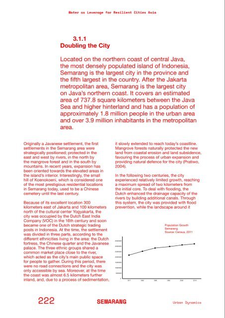
Population Growth<br />
Semarang<br />
Source: Census, 2011<br />
1971 1980 1990 1995 2000 2010<br />
1880<br />
A small Dutch settlement behind<br />
<strong>the</strong> mangroves.<br />
1970<br />
The expantion of Semarang’s<br />
harbour pushes <strong>the</strong> mangrove<br />
area away.<br />
Current<br />
retained part of <strong>the</strong> precipitation and prevented<br />
sea flooding and landslides. In addition, fresh<br />
water w<strong>as</strong> mainly provided from groundwater<br />
and surface water, including rivers, canals and<br />
small water reservoirs.<br />
Considerable expansions started with <strong>the</strong> first<br />
main infr<strong>as</strong>tructural changes. First, a mail road<br />
w<strong>as</strong> introduced, connecting Semarang with<br />
<strong>the</strong> rest of Java and changing <strong>the</strong> city’s urban<br />
growth from a south–north orientation to an<br />
e<strong>as</strong>t–west orientation along <strong>the</strong> infr<strong>as</strong>tructure.<br />
Secondly, <strong>the</strong> railway w<strong>as</strong> implemented at <strong>the</strong><br />
end of <strong>the</strong> 19th century following <strong>the</strong> same<br />
direction. The city harbour w<strong>as</strong> expanded<br />
and improved in 1861. Much later, after <strong>the</strong><br />
Japanese occupation (1942–45) and <strong>the</strong><br />
independence struggle (1945–49), Semarang<br />
experienced an economic boom sparked<br />
by industry, which led to <strong>the</strong> beginning of<br />
considerable urban sprawl. The new expansion<br />
caused de<strong>for</strong>estation of <strong>the</strong> mangroves, which<br />
were replaced by new industrial facilities, fish<br />
farming ponds and urbanization (100 Resilient<br />
Cities, 2016).<br />
Today <strong>the</strong> city is mainly growing inland,<br />
particularly in <strong>the</strong> southwestern are<strong>as</strong>. The<br />
population count h<strong>as</strong> reached 1.7 million<br />
inhabitants, of which 48.4% live in urban<br />
are<strong>as</strong>. The city’s surface area is 373.70 square<br />
kilometers, with a density of 4,627 inhabitants<br />
per square kilometer. Twenty-one percent of<br />
<strong>the</strong> surface is dedicated to agriculture (i.e. <strong>the</strong><br />
cultivation of rice, corn and c<strong>as</strong>sava), while<br />
42.17% is used <strong>for</strong> residential purposes (Kota<br />
Semarang Dalam Angka, 2017).<br />
On a social level, <strong>the</strong>re appears to be a<br />
disconnection between government and large<br />
segments of society, which is reflected in <strong>the</strong><br />
lack of coordination of dis<strong>as</strong>ter management<br />
and awareness campaigns. Since v<strong>as</strong>t are<strong>as</strong><br />
of <strong>the</strong> city are unregulated, developments<br />
and large social segments rely on in<strong>for</strong>mal<br />
provision systems. The local government is<br />
now working to create a link between bottomup<br />
and top-down initiatives. According to<br />
<strong>the</strong> Determination and Location Program <strong>for</strong><br />
Housing Environment and Slum Residents,<br />
<strong>the</strong>re are currently more than 62 illegal<br />
settlements in <strong>the</strong> city, compromising a surface<br />
222 SEMARANG<br />
Urban Dynamics<br />
PART 2/Background In<strong>for</strong>mation on <strong>the</strong> Partner Cities<br />
223