Water as Leverage- Setting the scene for a call for action
- No tags were found...
You also want an ePaper? Increase the reach of your titles
YUMPU automatically turns print PDFs into web optimized ePapers that Google loves.
<strong>Water</strong> <strong>as</strong> <strong>Leverage</strong> <strong>for</strong> Resilient Cities Asia <strong>Setting</strong> <strong>the</strong> Scene <strong>for</strong> a Call <strong>for</strong> Action Content<br />
To address <strong>the</strong> issues at <strong>the</strong> source, Semarang<br />
h<strong>as</strong> been developing several ecozones: <strong>the</strong><br />
ecohousing around Madukoro road and <strong>the</strong><br />
Keluharan village, <strong>the</strong> UNNES eco-university,<br />
<strong>the</strong> Wijayakusuma Industrial Park and <strong>the</strong><br />
ecozone around <strong>the</strong> Jatibarang reservoir<br />
(Yuli<strong>as</strong>tuti, Wahyono, Syafrudin & Sariffudin,<br />
2017; Murtini et al., 2017). These are<br />
developed to preserve <strong>the</strong> environment around<br />
<strong>the</strong> are<strong>as</strong>, to set an example <strong>for</strong> sustainable<br />
development and to create awareness<br />
of pollution issues. There might still be<br />
opportunities to improve w<strong>as</strong>te management in<br />
existing districts. For one, only 34% of <strong>the</strong> city<br />
h<strong>as</strong> w<strong>as</strong>te management and <strong>the</strong>re is only one<br />
landfill at Jatibarang. Concrete possibilities to<br />
extend w<strong>as</strong>te management include community<br />
w<strong>as</strong>te management and creating an extra<br />
landfill (Baba, Purwanto & Sunoko, 2012).<br />
Fur<strong>the</strong>rmore, de<strong>for</strong>estation and a rising amount<br />
of personal vehicles have had quite an impact<br />
on <strong>the</strong> air quality in Semarang (Gravitiani &<br />
Kristiani, 2015). At this point, only 15% of <strong>the</strong><br />
city is green space, which is far below <strong>the</strong><br />
25% minimum. As such, re<strong>for</strong>estation and<br />
creation of public parks could be opportunities<br />
(Setyowati, Martuti & Amin, 2016). In order<br />
to manage <strong>the</strong> levels of personal vehicles,<br />
Semarang is investing in public transport such<br />
<strong>as</strong> <strong>the</strong> Bus Rapid Transit. Attempts are made<br />
to reduce air pollution indirectly by using LED<br />
light <strong>for</strong> street lights and by reducing emissions<br />
from air conditioning (WWF, 2016).<br />
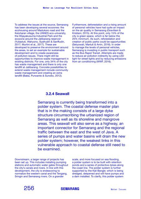
h<strong>as</strong> nothing to do with <strong>the</strong> public ponds that<br />
are lo<strong>call</strong>y named ‘polders’ <strong>as</strong> well. The co<strong>as</strong>tal<br />
defense m<strong>as</strong>ter plan that is currently under<br />
construction consists of a large dyke structure<br />
surrounding <strong>the</strong> urbanized region of Semarang<br />
<strong>as</strong> well <strong>as</strong> its shoreline and mangrove are<strong>as</strong>.<br />
This seawall will also serve <strong>as</strong> a highway,<br />
and is to become an important corridor <strong>for</strong><br />
Semarang and <strong>the</strong> e<strong>as</strong>t and west of Java. The<br />
new dyke is projected around existing b<strong>as</strong>ins<br />
and ponds near <strong>the</strong> shore, disconnecting <strong>the</strong>m<br />
Fish ponds<br />
Demak Rural Area<br />
from <strong>the</strong> sea and thus creating water storage<br />
b<strong>as</strong>ins <strong>for</strong> heavy rainfall. A series of pumps<br />
will drain <strong>the</strong> new polder system, keeping an<br />
artificially low water level in order to allow<br />
rivers to discharge into <strong>the</strong> b<strong>as</strong>ins. However,<br />
<strong>the</strong> low water level removes <strong>the</strong> natural estuary<br />
system with its transition from fresh to salt<br />
water. Though <strong>the</strong> plans are already being<br />
discussed on all levels of governance, <strong>the</strong><br />
weakest links within this approach of co<strong>as</strong>tal<br />
defense still need to be examined.<br />
Flood wall with<br />
breaches<br />
Harbor<br />
3.2.4 Seawall<br />
Rain water buffer<br />
Fresh water b<strong>as</strong>in<br />
Fresh water b<strong>as</strong>in<br />
Rain water buffer<br />
Semarang is currently being trans<strong>for</strong>med into a<br />
polder system. The co<strong>as</strong>tal defense m<strong>as</strong>ter plan<br />
that is in <strong>the</strong> making consists of a large dyke<br />
structure circumscribing <strong>the</strong> urbanized region of<br />
Semarang <strong>as</strong> well <strong>as</strong> its shoreline and mangrove<br />
are<strong>as</strong>. This seawall will also serve <strong>as</strong> a highway, an<br />
important connector <strong>for</strong> Semarang and <strong>the</strong> regional<br />
traffic between <strong>the</strong> e<strong>as</strong>t and <strong>the</strong> west of Java. A<br />
series of pumps and water b<strong>as</strong>ins will drain <strong>the</strong> new<br />
polder system; however, <strong>the</strong> weakest links in this<br />
vulnerable approach to co<strong>as</strong>tal defense still need to<br />
be examined.<br />
Pump<br />
Future sea wall<br />
Pump<br />
Future sea wall<br />
The new dam in rural<br />
and urban context,<br />
protecting <strong>the</strong> co<strong>as</strong>t but<br />
removing <strong>the</strong> relation<br />
between sea and land.<br />
Downstream, a larger range of projects h<strong>as</strong><br />
been set up. This includes installing pumping<br />
stations and automatic water gates throughout<br />
<strong>the</strong> city’s canals and rivers. In line with this<br />
development, <strong>the</strong> city is endeavoring to<br />
normalize <strong>the</strong> western canal and <strong>the</strong> Tengang,<br />
Sringin and Semarang rivers. On a grander<br />
scale, and more focused on sea flooding,<br />
a polder system is to be built with retention<br />
ponds and a series of protective dykes along<br />
<strong>the</strong> co<strong>as</strong>t line. The polder system is fur<strong>the</strong>r<br />
supported by <strong>the</strong> Kali Banger, which is being<br />
dredged, deepened and will have pumps and<br />
a dam installed. To clarify, this polder system<br />
Proposal <strong>for</strong> a new<br />
dam/highway, creating<br />
a polder system<br />
landwards.<br />
256 SEMARANG<br />
<strong>Water</strong> Issues<br />
PART 2/Background In<strong>for</strong>mation on <strong>the</strong> Partner Cities<br />
257


