NKOMATI ANTHRACITE (PTY) LIMITED - Sentula Mining
NKOMATI ANTHRACITE (PTY) LIMITED - Sentula Mining
NKOMATI ANTHRACITE (PTY) LIMITED - Sentula Mining

You also want an ePaper? Increase the reach of your titles
YUMPU automatically turns print PDFs into web optimized ePapers that Google loves.
Sampling<br />
Points<br />
Environmental Impact Assessment Report: Nkomati Anthracite (Pty) Limited,<br />
Madadeni Opencast <strong>Mining</strong> Project Page 25<br />
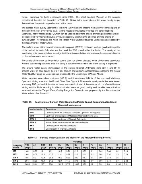
water. Sampling has been undertaken since 2008. The latest qualities (August) of the samples<br />
collected at the mine are illustrated in Table 12. Below is the description of the water quality as per<br />
the results of the monitoring undertaken at the mine.<br />
The surface water quality upstream of the mine (SRW1) shows that the Komati River in these parts of<br />
the catchment is of a very good state. All the measured variables recorded low concentrations.<br />
Sulphates, heavy metals and pH, which can be used to determine effects of mining on surface water,<br />
also recorded very low and neutral levels, respectively signifying the absence of mine effects on<br />
surface water. All variables are within the Target Water Quality Range for Domestic use proposed by<br />
the Department of Water Affairs.<br />
The surface water at the downstream monitoring point (SRW 3) continued to show good water quality.<br />
pH is neutral, to basic Sulphates are low and the TDS is well within the limits. The quality at this<br />
monitoring point does not show any sign that the mining activities upstream are having any influence<br />
on the surface water environment.<br />
The quality of the water at the pollution control dam has shown elevated levels of elements associated<br />
with the coal mining activities. Due to it being a pollution control dam, this water quality is expected.<br />
The ground water quality downstream of the current Nkomati Anthracite mine (BH 4 and BH 6)<br />
showed water of poor quality due to TDS, sodium and calcium concentrations exceeding the Target<br />
Water Quality Range for Domestic use proposed by the Department of Water Affairs.<br />
Water samples were taken upstream (MD 2) and downstream (MD 1) of the proposed Madadeni<br />
Opencast <strong>Mining</strong> area from the Komati River. See Figure 9. Three water quality variables were looked<br />
at namely TDS, pH and Sulphates as these variables indicated if the water would be affected by coal<br />
mining activity. Both sampling localities indicated water of good quality and variable concentrations<br />
were well within the Target Water Quality Range for Domestic use proposed by the Department of<br />
Water Affairs. See Table 12.<br />
Table 11: Description of Surface Water Monitoring Points On and Surrounding Madadeni<br />
Opencast mining area<br />
Monitoring site Description<br />
MD1 Downstream of the proposed Madadeni Opencast mining area<br />
MD2 Upstream of the proposed Madadeni Opencast mining area<br />
SRW 1 Komati River, upstream of Nkomati Anthracite<br />
SRW 3 Komati River, downstream of Nkomati Anthracite<br />
BH 4 Downstream of Nkomati Anthracite<br />
BH 6 Downstream of Nkomati Anthracite<br />
Table 12: Surface Water Quality in the Vicinity of the Proposed <strong>Mining</strong> Project.<br />
TDS<br />
(Mg/l)<br />
pH<br />
SO4<br />
(Mg/l)<br />
EC<br />
(mS/m)<br />
Ca<br />
(Mg/l)<br />
<strong>NKOMATI</strong> <strong>ANTHRACITE</strong> (<strong>PTY</strong>) <strong>LIMITED</strong><br />
Mg<br />
(Mg/l)<br />
Variables<br />
Na<br />
(Mg/l)<br />
K<br />
(Mg/l)<br />
Fe<br />
(Mg/l)<br />
Mn<br />
(Mg/l)<br />
F<br />
(Mg/l)<br />
Cl<br />
(Mg/l)<br />
MD1 160 8.06 12 23 10.7 9.71 21.0 0.75 0.11 0.01 0.36 22 0.18<br />
MD2 160 8.08 12.1 23.6 110 9.89 22.2 22.2 0.12 0.01 0.32 23 0.23<br />
SW 1 156 8.2 12.4 25.8 10.9 9.99 28.3 0.97 0.17 0.01 0.43 25 0.1<br />
SW 3 204 8.25 15.7 31.6 12.4 11.7 37.5 0.97 0.11 0.01 0.44 37 0.08<br />
BH 4 3694 5.44 127 578 102.9 27.2 1095 9.59 18 2.9 1.3 2100 0.01<br />
COMPILED BY GEOVICON ENVIRONMENTAL (<strong>PTY</strong>) LTD<br />
Al<br />
(Mg/l)