Western Ghats Kokum Foundation - Organic Farming Association of ...
Western Ghats Kokum Foundation - Organic Farming Association of ...
Western Ghats Kokum Foundation - Organic Farming Association of ...

Create successful ePaper yourself
Turn your PDF publications into a flip-book with our unique Google optimized e-Paper software.
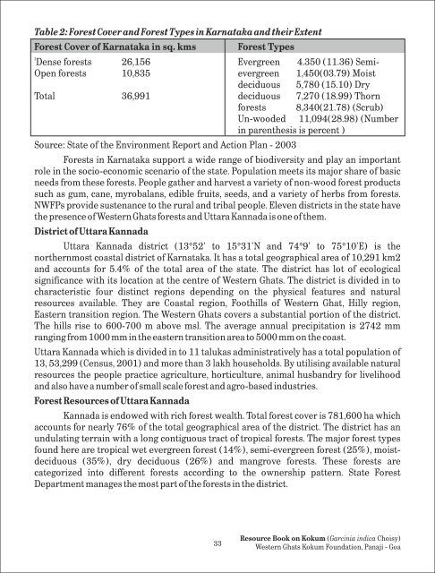
Table 2: Forest Cover and Forest Types in Karnataka and their Extent<br />
Forest Cover <strong>of</strong> Karnataka in sq. kms Forest Types<br />
t<br />
Dense forests 26,156<br />
Evergreen 4.350 (11.36) Semi-<br />
Open forests 10,835 evergreen 1,450(03.79) Moist<br />
deciduous 5,780 (15.10) Dry<br />
Total 36,991 deciduous 7,270 (18.99) Thorn<br />
forests 8,340(21.78) (Scrub)<br />
Un-wooded 11,094(28.98) (Number<br />
in parenthesis is percent )<br />
Source: State <strong>of</strong> the Environment Report and Action Plan - 2003<br />
Forests in Karnataka support a wide range <strong>of</strong> biodiversity and play an important<br />
role in the socio-economic scenario <strong>of</strong> the state. Population meets its major share <strong>of</strong> basic<br />
needs from these forests. People gather and harvest a variety <strong>of</strong> non-wood forest products<br />
such as gum, cane, myrobalans, edible fruits, seeds, and a variety <strong>of</strong> herbs from forests.<br />
NWFPs provide sustenance to the rural and tribal people. Eleven districts in the state have<br />
the presence <strong>of</strong> <strong>Western</strong> <strong>Ghats</strong> forests and Uttara Kannada is one <strong>of</strong> them.<br />
District <strong>of</strong> Uttara Kannada<br />
Uttara Kannada district (13°52' to 15°31'N and 74°9' to 75°10'E) is the<br />
northernmost coastal district <strong>of</strong> Karnataka. It has a total geographical area <strong>of</strong> 10,291 km2<br />
and accounts for 5.4% <strong>of</strong> the total area <strong>of</strong> the state. The district has lot <strong>of</strong> ecological<br />
significance with its location at the centre <strong>of</strong> <strong>Western</strong> <strong>Ghats</strong>. The district is divided in to<br />
characteristic four distinct regions depending on the physical features and natural<br />
resources available. They are Coastal region, Foothills <strong>of</strong> <strong>Western</strong> Ghat, Hilly region,<br />
Eastern transition region. The <strong>Western</strong> <strong>Ghats</strong> covers a substantial portion <strong>of</strong> the district.<br />
The hills rise to 600-700 m above msl. The average annual precipitation is 2742 mm<br />
ranging from 1000 mm in the eastern transition area to 5000 mm on the coast.<br />
Uttara Kannada which is divided in to 11 talukas administratively has a total population <strong>of</strong><br />
13, 53,299 (Census, 2001) and more than 3 lakh households. By utilising available natural<br />
resources the people practice agriculture, horticulture, animal husbandry for livelihood<br />
and also have a number <strong>of</strong> small scale forest and agro-based industries.<br />
Forest Resources <strong>of</strong> Uttara Kannada<br />
Kannada is endowed with rich forest wealth. Total forest cover is 781,600 ha which<br />
accounts for nearly 76% <strong>of</strong> the total geographical area <strong>of</strong> the district. The district has an<br />
undulating terrain with a long contiguous tract <strong>of</strong> tropical forests. The major forest types<br />
found here are tropical wet evergreen forest (14%), semi-evergreen forest (25%), moistdeciduous<br />
(35%), dry deciduous (26%) and mangrove forests. These forests are<br />
categorized into different forests according to the ownership pattern. State Forest<br />
Department manages the most part <strong>of</strong> the forests in the district.<br />
33<br />
Resource Book on <strong>Kokum</strong> (Garcinia indica Choisy)<br />
<strong>Western</strong> <strong>Ghats</strong> <strong>Kokum</strong> <strong>Foundation</strong>, Panaji - Goa