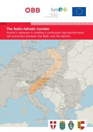
Inhalt | Contens - baltic-adriatic.eu
Inhalt | Contens - baltic-adriatic.eu
Inhalt | Contens - baltic-adriatic.eu

Sie wollen auch ein ePaper? Erhöhen Sie die Reichweite Ihrer Titel.
YUMPU macht aus Druck-PDFs automatisch weboptimierte ePaper, die Google liebt.
Ein Problem des Schrägen Durchganges<br />
war immer die Abseitslage der zweitgrößten<br />
Stadt Österreichs, bedingt<br />
durch die lange Nordsüd-Erstreckung<br />
der Koralm-Barriere. So existierten dort<br />
noch im 19. Jh. mittelalterliche Zustände<br />
des Säumerverkehrs in einer Zeit des<br />
beginnenden Eisenbahnbaues. Erst die<br />
Köflacher Kohle, die in Waldstein und<br />
Frantschach bei Wolfsberg Absatz fand<br />
(erstes Schienenwalzwerk Europas!),<br />
bedingte einen Pack-Güterweg-Ausbau,<br />
finanziell allein von den Gewerken<br />
getragen, der einen Fuhrverkehr höherer<br />
Achslasten erstmalig erlaubte. Mit dem<br />
Verlust des Draudurchbruchtales der<br />
Untersteiermark wurde die Verkehrsaufspaltung<br />
im Schrägen Durchgang<br />
eine territorialstrategische Frage, die<br />
das faschistische Italien in Wien sogar<br />
ansprach. Nach Aussagen des Triestiner<br />
Geographen Giorgio Valussi (später an<br />
der Universität Udine) gab es in der<br />
Zeit der Kooperation Dollfuss–Mussolini<br />
eine Machbarkeitsdiskussion eines die<br />
Pack querenden Eisenbahnprojektes.<br />
Italienische Kreditmittel waren schließlich<br />
in der Zwischenkriegszeit für Kärnten<br />
bei den staatlichen Programmen<br />
gegen die hohe Arbeitslosigkeit („Packer<br />
Höhenstraße“, „Großglockner Hochalpenstraße“)<br />
mit beteiligt. Erst jetzt<br />
kann der Pack-Übergang im Sinne<br />
einer „Via Strata“ als Straße bezeichnet<br />
werden und im System Ostsee-Adria-<br />
Korridor mit eingebunden werden<br />
(Straßen-Direktanbindung von Graz als<br />
zweitgrößte Stadt Österreichs). Der<br />
Hochleistungs-Straßenbau zu Ende<br />
des 20. Jh. wird diese Aufspaltung<br />
zwischen S6/S36 und A2 fortführen,<br />
und wird dies durch die Aufnahme<br />
der bisherigen Landesstraße B317<br />
Friesacher Straße als „n<strong>eu</strong>e“ bemautbare<br />
Schnellstraße S37 Klagenfurter<br />
Straße im Jahre 2006 in das höchstrangige<br />
Straßennetz mit Ausbauplänen<br />
bis 2015 untermauern.<br />
Aufspaltung des Schrägen Durchganges | Splitting off of the „Diagonal Passage“ 11<br />
4. Aufspaltung des Schrägen Durchganges zur<br />
Anbindung von Graz | Splitting off of the „Diagonal<br />
Passage“ for the connection to Graz<br />
One problem of the „Diagonal Passage“ has<br />
always been the fact that the second largest<br />
city in Austria is somewhat set apart because<br />
of the lengthy north-south expanse of the<br />
Koralm barrier. Thus even as late as the 19 th<br />
century, in the period when railway construction<br />
was just beginning, mediaeval forms of transport<br />
such as packhorses were still in existence<br />
here. It was only Köflach coal, which was sold<br />
at Waldstein and Frantschach bei Wolfsberg<br />
(the site of the first rolling mill for rails in<br />
Europe) that gave rise to an expansion of the<br />
packhorse goods transport route, financially<br />
supported entirely by the shareholders of the<br />
mining company, making haulage transport<br />
with higher axle loads possible for the first<br />
time. With the loss of the breakthrough valley of<br />
the Drava to Lower Styria, the splitting up of<br />
transport in the „Diagonal Passage“ became<br />
a question of territorial strategy, actually<br />
addressed by Fascist Italy in Vienna. According<br />
to the Trieste based geographer Giorgio Valussi<br />
(who was later based at the University of<br />
Udine), at the time of the Dollfuss–Mussolini<br />
co-operation there was discussion of the<br />
feasibility of a railway project crossing the<br />
Pack. Italian loan funds were ultimately involved<br />
in the inter-war period for Carinthia in the<br />
context of the government’s programmes to<br />
combat high unemployment (the „Packer<br />
Höhenstrasse“, the „Grossglockner Hochalpenstrasse“).<br />
Only now can the Pack crossing be<br />
designated as a „motorway“ in the sense of<br />
a „Via Strata“ and incorporated in the Baltic-<br />
Adriatic corridor system (direct road connection<br />
to Graz as the second largest city in Austria).<br />
The high speed road construction at the end of<br />
the 20 th century will continue this splitting up<br />
between the S6/S36 and the A2, and this is<br />
being underpinned by the inclusion, in 2006,<br />
of the former provincial motorway, the B317<br />
Friesacher Strasse, as the „new“ express toll<br />
road, the S37 Klagenfurter Strasse, in the top<br />
ranking road network with expansion plans as<br />
far as 2015.<br />
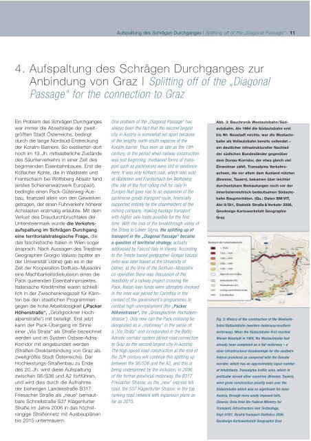
Abb. 3: Bauchronik Westautobahn/Südautobahn.<br />
Als 1964 die Südautobahn erst<br />
bis Wr. N<strong>eu</strong>stadt reichte, war die Westautobahn<br />
als Vollautobahn bereits vollendet –<br />
ein d<strong>eu</strong>tlicher infrastruktureller Nachteil<br />
der südlichen Bundesländer gegenüber<br />
dem Donau-Korridor, der etwa gleich viel<br />
Einwohner zählt. Transalpine Verkehrsachsen,<br />
die vor allem dem Ausland nützten<br />
(Brenner, Tauern), bekamen über leichter<br />
durchsetzbare Bemautungen noch vor der<br />
innerösterreichisch bed<strong>eu</strong>tsamen Südautobahn<br />
Bauprioritäten. (Qu.: Daten BM:VIT,<br />
Abt II/St1, Statistik Straße & Verkehr 2006,<br />
Geodesign Kartowerkstatt Geographie<br />
Graz<br />
Fig. 3: History of the construction of the Westautobahn/Südautobahn<br />
(western motorway/southern<br />
motorway). When the Südautobahn first reached<br />
Wiener N<strong>eu</strong>stadt in 1964, the Westautobahn had<br />
already been completed as a full motorway – a<br />
clear infrastructural disadvantage for the southern<br />
federal provinces as compared with the Danube<br />
corridor, which has an approximately equal number<br />
of inhabitants. Transalpine traffic axes, which in<br />
particular served other countries (Brenner, Tauern),<br />
were given construction priority even over the<br />
Südautobahn which was so significant for inner<br />
Austria, through more easily imposed tolls.<br />
(Source: Data from the Federal Ministry for<br />
Transport, Infrastructure and Technology,<br />
Dept II/St1, Road & Transport Statistics 2006,<br />
Geodesign Kartowerkstatt Geographie Graz