

Land Use Plan – 2002 - Stanly County, North Carolina
Land Use Plan – 2002 - Stanly County, North Carolina
Land Use Plan – 2002 - Stanly County, North Carolina

Create successful ePaper yourself
Turn your PDF publications into a flip-book with our unique Google optimized e-Paper software.
STANLY COUNTY<br />
Population trends for communities within <strong>Stanly</strong> <strong>County</strong> were also examined as indicated in<br />
Tables 2-2 and 2-3. From 1990 to 2000, Stanfield showed the greatest amount of growth with a<br />
115 percent increase in population. Oakboro showed the second-largest increase with a growth<br />
rate of 99.7 percent. These growth trends point to the close proximity of the two communities to<br />
growth in Union and Cabarrus Counties. Significant growth has also taken place in Norwood with<br />
an increase of 37 percent in population from, 1990 to 2000. This is likely due in part to its<br />
proximity to Tillery Reservoir. Locust grew over the same period by 24.5 percent. It is anticipated<br />
that growth will continue in the towns and unincorporated areas on the southwestern edge of the<br />
county and along NC 24/27 corridor. An acceleration of this growth rate is expected when the<br />
eastern portion of Interstate 485 is completed in 2003 along with the planned widening of NC<br />
24/27, NC 49, and U.S. 52 to four lanes.<br />
Population Projections<br />
Population projections for counties in <strong>North</strong> <strong>Carolina</strong> to the year 2020 have recently been<br />
released by the State of <strong>North</strong> <strong>Carolina</strong> Office of Budget and Management and are included in<br />
Tables 2-2 and 2-3. Generally these projections estimate that existing population growth trends<br />
in <strong>Stanly</strong> <strong>County</strong> and other central <strong>North</strong> <strong>Carolina</strong> counties. These projections predict that the<br />
population of <strong>Stanly</strong> <strong>County</strong> will continue to grow at a moderate pace over the next 20 years.<br />
The population is predicted to increase 10.8 percent between 2000 and 2010 to 64,372 people.<br />
The projections go on to predict that the population of the county will be 70,547 persons in 2020,<br />
a 9.6 percent increase between 2010 and 2020. At the end of the 20-year period, an additional<br />
12,447 persons are expected to be living in the county.<br />
Davidson, Montgomery, and Rowan Counties are expected to grow at rates similar to <strong>Stanly</strong><br />
<strong>County</strong> over the 20-year period identified in Tables 2-2 and 2-3.<br />
The pattern of significant population growth in the counties west of <strong>Stanly</strong> <strong>County</strong>—Cabarrus,<br />
Mecklenburg, and Union Counties—is expected to continue over the same analysis period.<br />
Cabarrus <strong>County</strong> is expected to grow 26.3 percent by 2010, and another 20.9 percent between<br />
2010 and 2020, ultimately arriving at a population of 200,092 in 2020. Union <strong>County</strong>—while<br />
growing at a faster rate—will arrive at a 2020 population of 210,738. By 2020, Mecklenburg<br />
<strong>County</strong>’s population is expected to reach 1,089,258. Between 2000 and 2010, Mecklenburg<br />
<strong>County</strong> is expected to grow 28.4 percent; between 2010 and 2020, it is predicted that the county<br />
will grow 22.0 percent.<br />
Similar projections for communities within <strong>Stanly</strong> <strong>County</strong> are not available.<br />
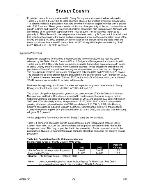
Table 2-4 compares population growth in unincorporated and incorporated areas of <strong>Stanly</strong><br />
<strong>County</strong>. From 1990 to 2000, the unincorporated areas grew at almost the same rate as the<br />
incorporated area. This may, in part, be due to the annexation of unincorporated areas in the<br />
past decade. Overall, unincorporated areas comprise almost 58 percent of the county’s overall<br />
population.<br />
Table 2-4. Population Growth, Unincorporated and<br />
Incorporated Areas of <strong>Stanly</strong> <strong>County</strong>, 1990-2000.<br />
Area 1990 2000<br />
Percent<br />
Change<br />
<strong>Stanly</strong> <strong>County</strong> Unincorporated Population 29,842 33,482 12.2<br />
Incorporated Totals 21,923 24,618 12.3<br />
Source: U.S. Census Bureau, 1990 and 2000.<br />
Note: Unincorporated population totals include figures for Red Cross. Red Cross<br />
incorporated subsequent to the completion of the U.S. Census.<br />
<strong>Land</strong> <strong>Use</strong> <strong>Plan</strong> 2-3 6/02


