

Land Use Plan – 2002 - Stanly County, North Carolina
Land Use Plan – 2002 - Stanly County, North Carolina
Land Use Plan – 2002 - Stanly County, North Carolina

Create successful ePaper yourself
Turn your PDF publications into a flip-book with our unique Google optimized e-Paper software.
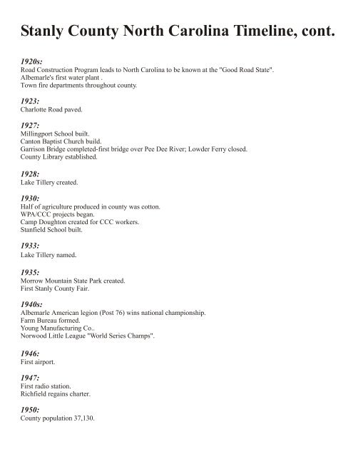
<strong>Stanly</strong> <strong>County</strong> <strong>North</strong> <strong>Carolina</strong> Timeline, cont.<br />
1920s:<br />
Road Construction Program leads to <strong>North</strong> <strong>Carolina</strong> to be known at the "Good Road State".<br />
Albemarle's first water plant .<br />
Town fire departments throughout county.<br />
1923:<br />
Charlotte Road paved.<br />
1927:<br />
Millingport School built.<br />
Canton Baptist Church build.<br />
Garrison Bridge completed-first bridge over Pee Dee River; Lowder Ferry closed.<br />
<strong>County</strong> Library established.<br />
1928:<br />
Lake Tillery created.<br />
1930:<br />
Half of agriculture produced in county was cotton.<br />
WPA/CCC projects began.<br />
Camp Doughton created for CCC workers.<br />
Stanfield School built.<br />
1933:<br />
Lake Tillery named.<br />
1935:<br />
Morrow Mountain State Park created.<br />
First <strong>Stanly</strong> <strong>County</strong> Fair.<br />
1940s:<br />
Albemarle American legion (Post 76) wins national championship.<br />
Farm Bureau formed.<br />
Young Manufacturing Co..<br />
Norwood Little League "World Series Champs".<br />
1946:<br />
First airport.<br />
1947:<br />
First radio station.<br />
Richfield regains charter.<br />
1950:<br />
<strong>County</strong> population 37,130.


