Land Use Plan – 2002 - Stanly County, North Carolina
Land Use Plan – 2002 - Stanly County, North Carolina
Land Use Plan – 2002 - Stanly County, North Carolina
Create successful ePaper yourself
Turn your PDF publications into a flip-book with our unique Google optimized e-Paper software.
STANLY COUNTY<br />
production closely following those numbers. Of the cash receipts generated in the county, 80<br />
percent are from livestock sales and 20 percent from crop sales.<br />
Preserving prime farmland areas as an important resource is essential for the community as<br />
well as for future generations. According to the USDA, “It is of major importance in meeting the<br />
Nation’s short and long-range needs for food and fiber. The acreage of high-quality farmland is<br />
limited, and the USDA recognizes that government at local, state, and federal levels, as well as<br />
individuals, must encourage and facilitate the wise use of our nation’s prime farmland.”<br />
According to the American Farmland Trust’s 1997 report Farming on the Edge, the Southern<br />
Piedmont Major <strong>Land</strong> Resource Area (MLRA)—a zone that includes <strong>Stanly</strong> <strong>County</strong> and extends<br />
from <strong>North</strong>ern Virginia to east-central Alabama—was identified as the 21st most-threatened<br />
MRLA from among 127 MRLAs in the United States. This ranking was based on the relative<br />
high-quality of the MRLA in terms of soil characteristics and other factors, and relatively high<br />
development pressures in the region. Farming on the Edge recommends a series of general<br />
recommendations for highly-threatened, high-quality resource areas such as the Southern<br />
Piedmont (American Farmland Trust, 1997).<br />
Prime farmland is defined by the USDA as ‘soils that are best suited to producing food, feed,<br />
forage, fiber, and oilseed crops. Prime farmland soils produce the highest yields with minimal<br />
inputs of energy and economic resources.’ A good amount of moisture from precipitation or<br />
irrigation is usually received and the soil acidity or alkalinity level is acceptable. There are few or<br />
no rocks in the soil and water and air can easily seep through. Erosion is low and flooding during<br />
growing season is minimal. Slopes range usually from 0 to 6 percent.<br />
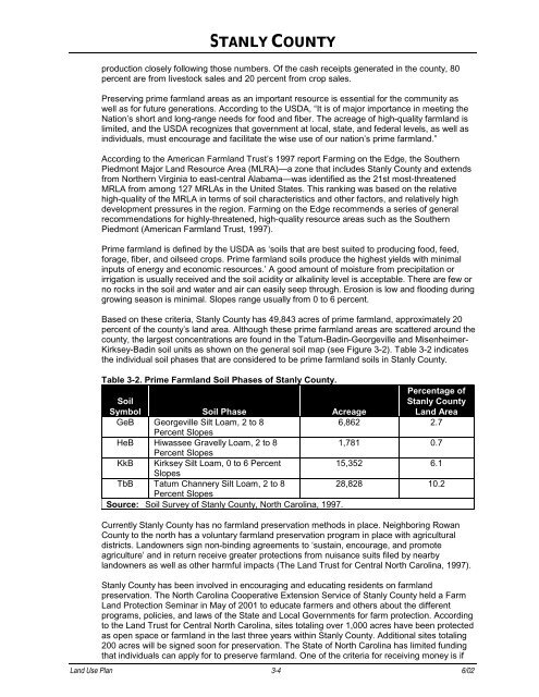
Based on these criteria, <strong>Stanly</strong> <strong>County</strong> has 49,843 acres of prime farmland, approximately 20<br />
percent of the county’s land area. Although these prime farmland areas are scattered around the<br />
county, the largest concentrations are found in the Tatum-Badin-Georgeville and Misenheimer-<br />
Kirksey-Badin soil units as shown on the general soil map (see Figure 3-2). Table 3-2 indicates<br />
the individual soil phases that are considered to be prime farmland soils in <strong>Stanly</strong> <strong>County</strong>.<br />
Table 3-2. Prime Farmland Soil Phases of <strong>Stanly</strong> <strong>County</strong>.<br />
Soil<br />
Percentage of<br />
<strong>Stanly</strong> <strong>County</strong><br />
Symbol Soil Phase Acreage<br />
<strong>Land</strong> Area<br />
GeB Georgeville Silt Loam, 2 to 8<br />
Percent Slopes<br />
6,862 2.7<br />
HeB Hiwassee Gravelly Loam, 2 to 8<br />
Percent Slopes<br />
1,781 0.7<br />
KkB Kirksey Silt Loam, 0 to 6 Percent<br />
Slopes<br />
15,352 6.1<br />
TbB Tatum Channery Silt Loam, 2 to 8<br />
Percent Slopes<br />
28,828 10.2<br />
Source: Soil Survey of <strong>Stanly</strong> <strong>County</strong>, <strong>North</strong> <strong>Carolina</strong>, 1997.<br />
Currently <strong>Stanly</strong> <strong>County</strong> has no farmland preservation methods in place. Neighboring Rowan<br />
<strong>County</strong> to the north has a voluntary farmland preservation program in place with agricultural<br />
districts. <strong>Land</strong>owners sign non-binding agreements to ‘sustain, encourage, and promote<br />
agriculture’ and in return receive greater protections from nuisance suits filed by nearby<br />
landowners as well as other harmful impacts (The <strong>Land</strong> Trust for Central <strong>North</strong> <strong>Carolina</strong>, 1997).<br />
<strong>Stanly</strong> <strong>County</strong> has been involved in encouraging and educating residents on farmland<br />
preservation. The <strong>North</strong> <strong>Carolina</strong> Cooperative Extension Service of <strong>Stanly</strong> <strong>County</strong> held a Farm<br />
<strong>Land</strong> Protection Seminar in May of 2001 to educate farmers and others about the different<br />
programs, policies, and laws of the State and Local Governments for farm protection. According<br />
to the <strong>Land</strong> Trust for Central <strong>North</strong> <strong>Carolina</strong>, sites totaling over 1,000 acres have been protected<br />
as open space or farmland in the last three years within <strong>Stanly</strong> <strong>County</strong>. Additional sites totaling<br />
200 acres will be signed soon for preservation. The State of <strong>North</strong> <strong>Carolina</strong> has limited funding<br />
that individuals can apply for to preserve farmland. One of the criteria for receiving money is if<br />
<strong>Land</strong> <strong>Use</strong> <strong>Plan</strong> 3-4 6/02


