

Land Use Plan – 2002 - Stanly County, North Carolina
Land Use Plan – 2002 - Stanly County, North Carolina
Land Use Plan – 2002 - Stanly County, North Carolina

Create successful ePaper yourself
Turn your PDF publications into a flip-book with our unique Google optimized e-Paper software.
Surface Waters<br />
STANLY COUNTY<br />
A significant part of the character of <strong>Stanly</strong> <strong>County</strong> is defined by manmade lakes (Tuckertown<br />
Reservoir, Narrows Reservoir, Falls Reservoir, and Tillery Reservoir) which together outline<br />
much of the eastern boundary of the county. The reservoirs also occupy a large amount of land<br />
area. Together the lakes cover 10,350 acres of land in <strong>Stanly</strong> <strong>County</strong> and adjoining Montgomery<br />
<strong>County</strong> including 6,638 acres within <strong>Stanly</strong> <strong>County</strong>. This represents 3.8 percent of <strong>Stanly</strong><br />
<strong>County</strong>’s land area.<br />
Existing <strong>Land</strong> <strong>Use</strong> Distribution<br />
Table 3-3 provides a summary of the distribution of the land use categories identified in Figure<br />
3-6. The analysis of the land use distribution is limited to the study area identified in Figures 1-2<br />
and 3-6 and excludes 42,600 acres of land either within incorporated areas of the county or<br />
those areas within ETJs.<br />
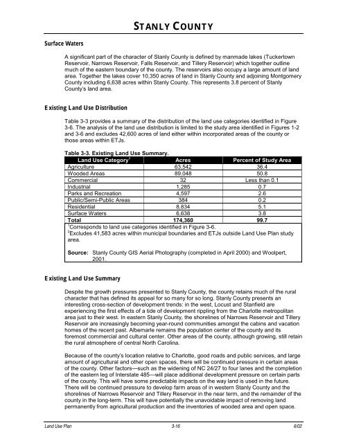
Table 3-3. Existing <strong>Land</strong> <strong>Use</strong> Summary.<br />
<strong>Land</strong> <strong>Use</strong> Category 1<br />
Acres Percent of Study Area<br />
Agriculture 63,542 36.4<br />
Wooded Areas 89,048 50.8<br />
Commercial 32 Less than 0.1<br />
Industrial 1,285 0.7<br />
Parks and Recreation 4,597 2.6<br />
Public/Semi-Public Areas 384 0.2<br />
Residential 8,834 5.1<br />
Surface Waters 6,638 3.8<br />
Total 174,360 99.7<br />
1<br />
Corresponds to land use categories identified in Figure 3-6.<br />
2<br />
Excludes 41,583 acres within municipal boundaries and ETJs outside <strong>Land</strong> <strong>Use</strong> <strong>Plan</strong> study<br />
area.<br />
Source: <strong>Stanly</strong> <strong>County</strong> GIS Aerial Photography (completed in April 2000) and Woolpert,<br />
2001.<br />
Existing <strong>Land</strong> <strong>Use</strong> Summary<br />
Despite the growth pressures presented to <strong>Stanly</strong> <strong>County</strong>, the county retains much of the rural<br />
character that has defined its appeal for so many for so long. <strong>Stanly</strong> <strong>County</strong> presents an<br />
interesting cross-section of development trends: in the west, Locust and Stanfield are<br />
experiencing the first effects of a tide of development rippling from the Charlotte metropolitan<br />
area just to their west. In eastern <strong>Stanly</strong> <strong>County</strong>, the shorelines of Narrows Reservoir and Tillery<br />
Reservoir are increasingly becoming year-round communities amongst the cabins and vacation<br />
homes of the recent past. Albemarle remains the population center of the county and its<br />
foremost commercial and cultural center. Other areas of the county, although growing, still retain<br />
the rural atmosphere of central <strong>North</strong> <strong>Carolina</strong>.<br />
Because of the county’s location relative to Charlotte, good roads and public services, and large<br />
amount of agricultural and other open spaces, there will be continued pressure in certain areas<br />
of the county. Other factors—such as the widening of NC 24/27 to four lanes and the completion<br />
of the eastern leg of Interstate 485—will place additional development pressure on certain parts<br />
of the county. This will have some predictable impacts on the way land is used in the future.<br />
There will be continued pressure to develop farm areas of in western <strong>Stanly</strong> <strong>County</strong> and the<br />
shorelines of Narrows Reservoir and Tillery Reservoir in the near term, and the remainder of the<br />
county in the long-term. This will have potentially the unavoidable impact of removing land<br />
permanently from agricultural production and the inventories of wooded area and open space.<br />
<strong>Land</strong> <strong>Use</strong> <strong>Plan</strong> 3-16 6/02


