Oder Cre~ -- Delhi Port Rowan LAKE ERIE Port Dover Figure 7. Main streams and watersheds of the Regional Municipality of Haldimand-Norfolk Hagersville Caledonia Cayuga ~--^ Rivers and streams Grand R. Watershed boundary Regional boundary LAKE ERIE
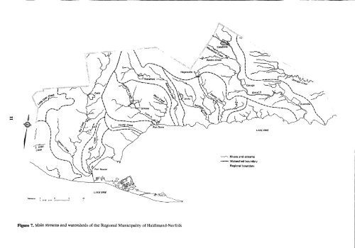
Table 3. Number and size of farms in the Regional Municipality of Haldimand-Norfolk No. of farms Size of farms 1966' 1981' All sizes 4 992 3 899 Less than 4 ha 215 199 (less than 10 ac) 4 to 28 ha 1 109 949 (10 to 70 ac) 28 to 53 ha 1919 1 249 (70 to 130 ac) 53 to 97 ha 1 354 937 (130to240ac) More than 97 ha 395 202 (more than 240 ac) 'Data compiledfrom Census of <strong>Canada</strong>, 1966, 1981 . Physiography and Drainage The two physiographic regions that dominate the Regional Municipality of Haldimand-Norfolk are the Norfolk sand plain and the Haldimand clay plain (3) . These are shown in Figure 6 along with smaller physiographic subregions and features . The Norfolk sand plain blank<strong>et</strong>s most of the former County of Norfolk in the western part of the Region . This plain slopes gently from the northwest to Lake Erie in the southeast . In the north, the low relief of the sand plain is broken by the Horseshoe moraines and the Mount Elgin ridges . The highest elevation in the region, 274 m, is attained on one of these ridges near Kelvin . The drop in elevation from this point to the Lake Erie water level is 102 m . The sands of the Norfolk sand plain are thought to have been deposited in shallow water stages of glacial lakes Whittlesey and Warren . They range in thickness from less than 1 m to over 20 m, although the average thickness is probably 5 to 10 m . The relief on the sand plain is subdued, except for the moraines and occasional eolian dunes which can range up to 10 m high . Near Lake Erie, the sand plains grade into several small silt and clay plains . The Horseshoe moraines and Mount Elgin ridges are som<strong>et</strong>imes partly buried by sands, but usually stand out in bold relief to the surrounding sand plains . The Horseshoe moraines, which include the Gait and Paris moraines, are composed mainly of gravelly sandy till . The Mount Elgin ridges, which include the Tillsonburg moraine, are composed mainly of silty clay loam till . Most of the drainage of the Norfolk sand plain is by relatively short rivers and streams that cut deeply, som<strong>et</strong>imes as much as 30m into the sand plain . The largest streams, Big Creek and Little Otter Creek, are shown in Figure 7 . Near the main streams and their tributaries, drainage is good, but in some intermorainal and interfluvial parts of the sand plain, drainage is poor and w<strong>et</strong> sands or organic soils occur . The Haldimand clay plain occupies most of the former County of Haldimand, in the eastern part of the region . The 12 topography ranges from rolling and dissected to almost level . The elevation ranges from about 218 m in the northwest near Caledonia to 172 m in the south at Lake Erie . The clays and silts of the clay plain are thought to have been deposited mainly during deep water stages of glacial lakes Whittlesey and Warren . Their thickness ranges from less than lm near the Onondaga escarpment, to almost 40 m southeast of Dunnville . Figure 8 . An aerial ~ iew ui' the Haldimand plain near Caledonia, showing typical terrain of gentle slopes and potholes Although much of the relief is related to dissection of the clays, especially near the Grand River, bedrock and older till underlying the clay also strongly influence the topography . One of the major bedrock influences is the Onondaga escarpment, a low escarpment that cuts across the clay plain from west of Hagersville to southeast of Dunnville . The escarpment is partly buried by Pleistocene glacial and lacustrine sediments (4), but near Hagersville it attains heights of 15 m and provides good bedrock exposures . Some small areas of limestone and dolostone bedrock are exposed at the surface near the Onondaga escarpment . From this escarpment to Lake Erie, bedrock is rarely more than 15 m below ground surface and accounts for the very gentle, south-sloping topography . North of the Onondaga escarpment where the clays thicken to as much as 40 m over shaley bedrock, the main relief is afforded by dissected clays and partially exhumed drumlins . The drumlins consist of loam till and are mostly concentrated b<strong>et</strong>ween the Grand River and the escarpment . East of the Grand River and just north of the Onondaga escarpment, where poorly drained clays and silts were ponded, the topography flattens out . In the southeast corner of the region to the south of the escarpment the rolling topography near the Lake Erie shore is due to the presence of some small till moraines. The Grand River and its tributaries drain a large part of the Haldimand clay plain (Figure 7) . The clays are usually more dissected and b<strong>et</strong>ter drained near the Grand River. There are areas of poorly drained clays on many of the flatter interfluvial plains . East of the Grand River, the Onondaga escarpment and the strike of the bedrock cause the drainage waters to flow eastward to the Welland River and its tributaries, such as Oswego Creek . The low slope and lack of gradient create some very poorly drained sections in this area . The drainage south of the Onondaga escarpment is (Continued on page 14)